File:(Map of the islands of Hispaniola and Puerto Rico). LOC 2003623402.tif
Jump to navigation
Jump to search

Size of this JPG preview of this TIF file: 800 × 570 pixels. Other resolutions: 320 × 228 pixels | 640 × 456 pixels | 1,024 × 730 pixels | 1,280 × 913 pixels | 2,560 × 1,825 pixels | 8,594 × 6,127 pixels.
Original file (8,594 × 6,127 pixels, file size: 150.65 MB, MIME type: image/tiff)
Captions
Captions
Add a one-line explanation of what this file represents
Summary
[edit]| Description |
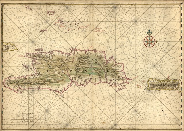
English: Relief shown pictorially. Shows coastal features, administrative districts, and settlements on the islands of Hispaniola and Puerto Rico. Pen-and-ink and watercolor. Attributed to Joan Vinckeboons by comparison with his other Dutch maps in Henry Harrisse collection. Described in Terrae incognitae, v. xvi, 1984. Richard W. Stephenson's The Henry Harrisse collection ... , p. 40; the first volume has binder's title "Manuscript maps of the West-Indies drawn by Joan Vingboons in 1639." LC Luso-Hispanic world, 42 Available also through the Library of Congress Web site as a raster image. |
||
| Title | [Map of the islands of Hispaniola and Puerto Rico]. | ||
| Shelf ID | G3291.S12 coll .H3 | ||
| Date | |||
| Source | https://www.loc.gov/item/2003623402/ | ||
| Author | Vinckeboons, Joan | ||
| Permission (Reusing this file) |
|
||
| Other versions |
|
||
| Location | Hispaniola · Puerto Rico | ||
| Part of | American Memory · Catalog · Cultural Landscapes · Geography And Map Division · Discovery And Exploration | ||
| Subject | Maps, Manuscript · Hispaniola · Discovery And Exploration · Early Works To 1800 · Puerto Rico |

._LOC_2003623402.jpg)
Licensing
[edit]|
This is a faithful photographic reproduction of a two-dimensional, public domain work of art. The work of art itself is in the public domain for the following reason:
The official position taken by the Wikimedia Foundation is that "faithful reproductions of two-dimensional public domain works of art are public domain".
This photographic reproduction is therefore also considered to be in the public domain in the United States. In other jurisdictions, re-use of this content may be restricted; see Reuse of PD-Art photographs for details. | ||||
File history
Click on a date/time to view the file as it appeared at that time.
| Date/Time | Thumbnail | Dimensions | User | Comment | |
|---|---|---|---|---|---|
| current | 01:46, 10 September 2018 |  | 8,594 × 6,127 (150.65 MB) | Fæ (talk | contribs) | LOC Maps https://www.loc.gov/item/2003623402/ #19008 |
You cannot overwrite this file.
File usage on Commons
The following page uses this file: