File:(Cadastral survey map of Squares A and B adjacent to Pennsylvania Avenue, N.W., Washington D.C. - new part of the Mall) LOC 88693116.tif
Jump to navigation
Jump to search

Size of this JPG preview of this TIF file: 748 × 600 pixels. Other resolutions: 299 × 240 pixels | 599 × 480 pixels | 958 × 768 pixels | 1,277 × 1,024 pixels | 2,554 × 2,048 pixels | 6,251 × 5,013 pixels.
Original file (6,251 × 5,013 pixels, file size: 89.65 MB, MIME type: image/tiff)
Captions
Captions
Add a one-line explanation of what this file represents
Summary
[edit]| Description |
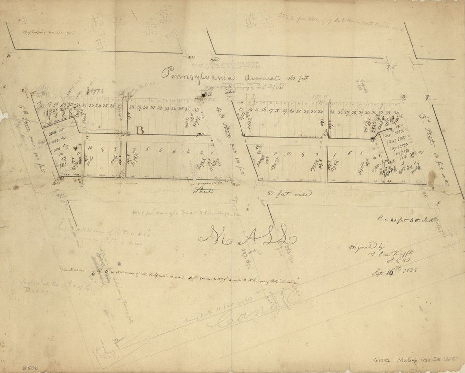
English: Covers blocks bounded by 6th St., Pennsylvania Av., 3rd St., and the former Missouri Av. N.W. Black ink, brown ink, and lead pencil. Torn, fold-lined, and mounted on cloth backing. Includes notes and computations. Available also through the Library of Congress Web site as a raster image. Phillips. Washington 890 Vault DCP |
||
| Title | [Cadastral survey map of Squares A and B adjacent to Pennsylvania Avenue, N.W., Washington D.C. : new part of the Mall] | ||
| Shelf ID | G3852.M3G46 1822 .D5 | ||
| Date | |||
| Source | https://www.loc.gov/item/88693116/ | ||
| Author | District Of Columbia. Office Of The Surveyor; De Krafft, F. C. | ||
| Permission (Reusing this file) |
|
||
| Other versions |
|
||
| Location | United States · Washington D.C. · District Of Columbia · Washington · The Mall | ||
| Part of | County Landownership Maps · Cultural Landscapes · Cities And Towns · Catalog · American Memory · Geography And Map Division | ||
| Subject | Washington (D.C.) · Maps, Manuscript · Mall, The (Washington, D.C.) · Washington · Mall, The · United States · Maps · District Of Columbia · Real Property · Manuscript Maps |

_LOC_88693116.jpg)
Licensing
[edit]|
This is a faithful photographic reproduction of a two-dimensional, public domain work of art. The work of art itself is in the public domain for the following reason:
The official position taken by the Wikimedia Foundation is that "faithful reproductions of two-dimensional public domain works of art are public domain".
This photographic reproduction is therefore also considered to be in the public domain in the United States. In other jurisdictions, re-use of this content may be restricted; see Reuse of PD-Art photographs for details. | ||||
File history
Click on a date/time to view the file as it appeared at that time.
| Date/Time | Thumbnail | Dimensions | User | Comment | |
|---|---|---|---|---|---|
| current | 01:45, 21 June 2018 |  | 6,251 × 5,013 (89.65 MB) | Fæ (talk | contribs) | LOC Maps https://www.loc.gov/item/88693116/ #22639 |
You cannot overwrite this file.
File usage on Commons
The following page uses this file: