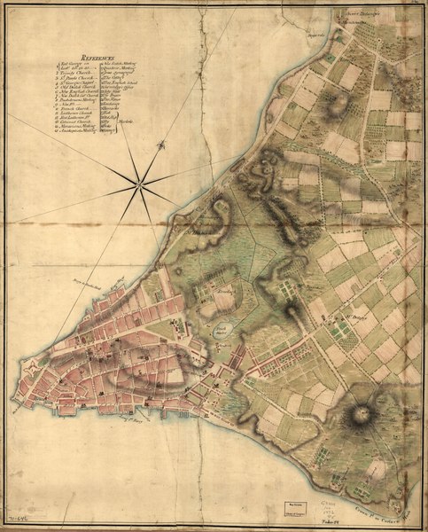
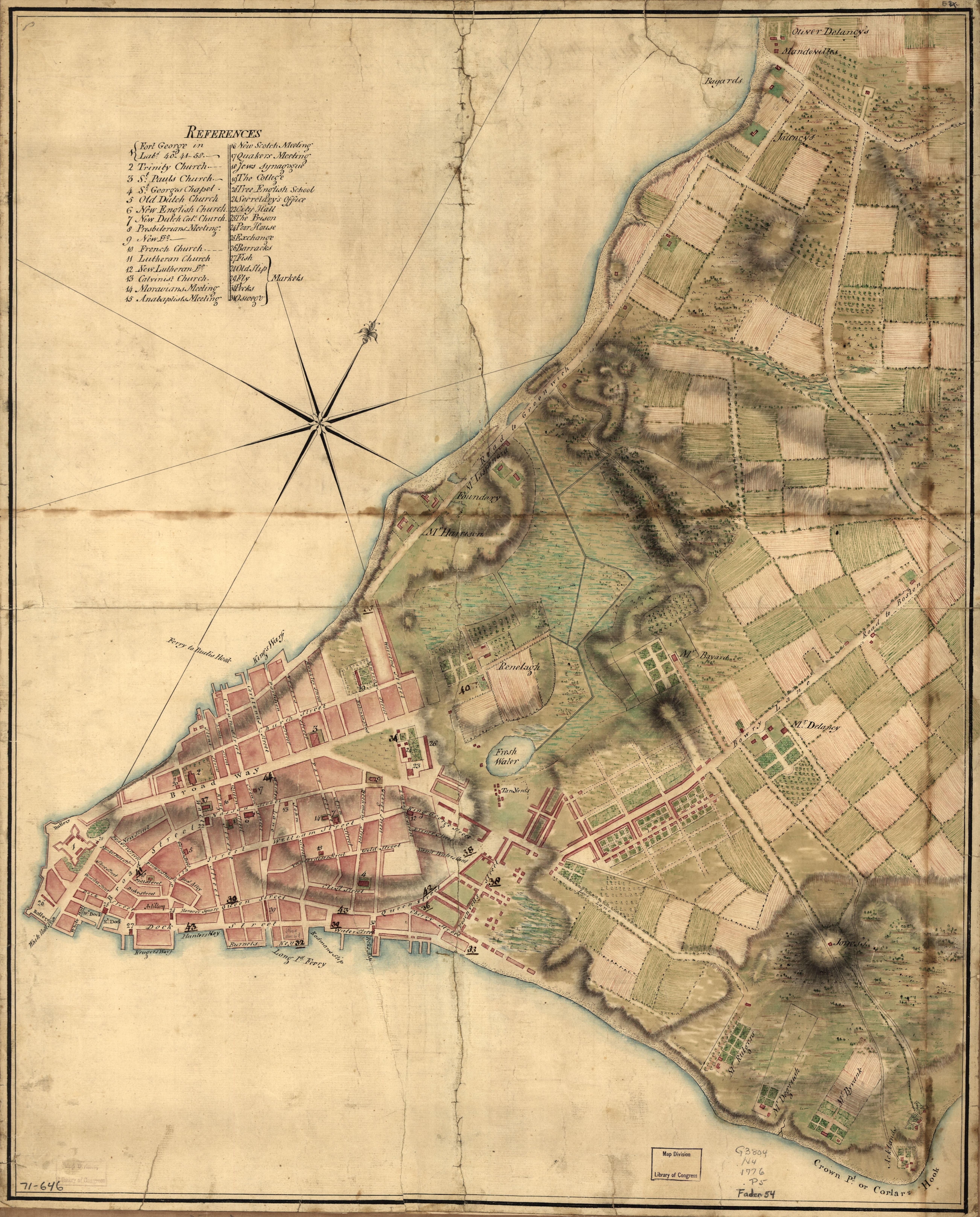
File:(A Plan of the city of New York. LOC gm71000646.tif
Jump to navigation
Jump to search
Size of this JPG preview of this TIF file: 483 × 600 pixels. Other resolutions: 193 × 240 pixels | 386 × 480 pixels | 618 × 768 pixels | 824 × 1,024 pixels | 1,649 × 2,048 pixels | 5,208 × 6,468 pixels.
Original file (5,208 × 6,468 pixels, file size: 96.37 MB, MIME type: image/tiff)
Captions
Captions
Add a one-line explanation of what this file represents
Summary
[edit]| Description |
English: Scale ca. 1:6,300. Title from Philip Lee Phillips' A list of maps of America. 1901. Manuscript, pen-and-ink and watercolor. Oriented with north toward the upper right. Relief shown by shading and hachures. LC Maps of North America, 1750-1789, 1109 Available also through the Library of Congress Web site as a raster image. Vault AACR2: 651 |
||
| Title | [A Plan of the city of New York. | ||
| Shelf ID | G3804.N4 1776 .P5 | ||
| Date | |||
| Source | https://www.loc.gov/item/gm71000646/ | ||
| Author | Unknown author | ||
| Permission (Reusing this file) |
|
||
| Other versions |
|
||
| Location | United States · New York City · New York · New York (State) | ||
| Part of | Military Battles And Campaigns · American Memory · Catalog · Geography And Map Division · American Revolution And Its Era: Maps And Charts Of North America And The West Indies, 1750-1789 | ||
| Subject | Maps, Manuscript · New York (N.Y.) · United States · Early Works To 1800 · New York · New York (State) |


Licensing
[edit]|
This is a faithful photographic reproduction of a two-dimensional, public domain work of art. The work of art itself is in the public domain for the following reason:
The official position taken by the Wikimedia Foundation is that "faithful reproductions of two-dimensional public domain works of art are public domain".
This photographic reproduction is therefore also considered to be in the public domain in the United States. In other jurisdictions, re-use of this content may be restricted; see Reuse of PD-Art photographs for details. | ||||
File history
Click on a date/time to view the file as it appeared at that time.
| Date/Time | Thumbnail | Dimensions | User | Comment | |
|---|---|---|---|---|---|
| current | 05:11, 23 June 2018 |  | 5,208 × 6,468 (96.37 MB) | Fæ (talk | contribs) | LOC Maps https://www.loc.gov/item/gm71000646/ #25117 |
You cannot overwrite this file.
File usage on Commons
The following page uses this file: