File:1946年頃以降のソ連・モンゴル(外蒙古)内日本人収容所分布および各地点死亡者発生状況概見図.pdf

Original file (2,550 × 1,650 pixels, file size: 6.95 MB, MIME type: application/pdf)
Captions
Captions
Summary
[edit]| Description |
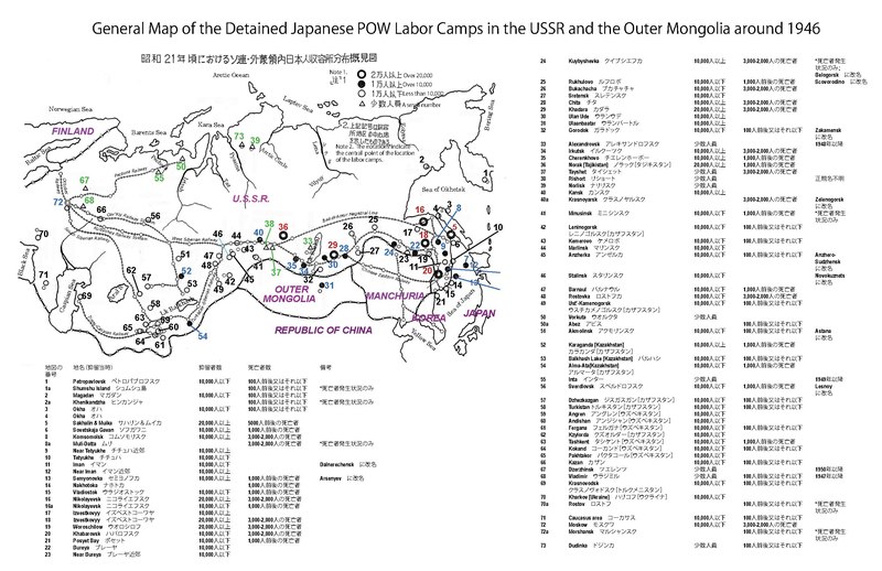
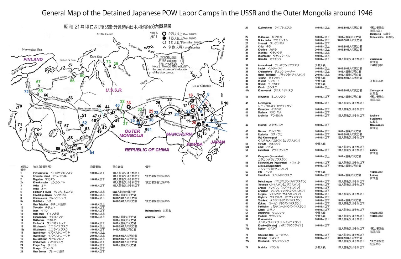
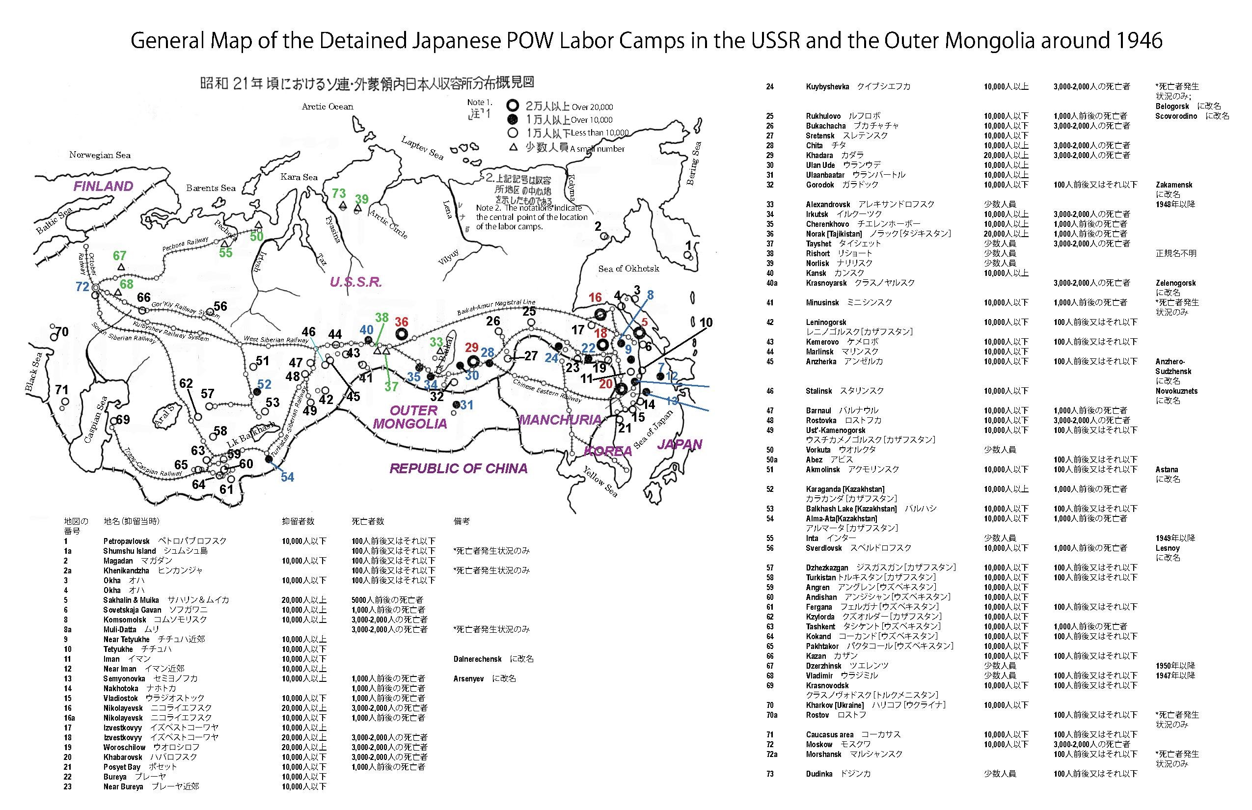
日本語: ソ連側の史料が全面提供されないなか、厚生省(現厚生労働省)によってまとめられた地図によれば、ソ連国内70か所をこえる収容所において抑留日本兵が強制労働に従事させられた。厚生省作成地図には各地点の抑留日本兵の動員数、死亡者数が含まれるが、地名はカタカナのみで記されてあったため、米国、英国ならびにソ連において発行されたソ連地図を参照し、地名を特定した。 (厚生省援護局。「昭和21年頃におけるソ連・外蒙領内日本人収容所分布概見図」『引揚げと援護三十年の歩み』厚生省。1976年。p56。厚生省社会・援護局50年史編纂委員会。「ソ連邦・モンゴル(外蒙古)内各地点死亡者発生状況概見図」『援護50年史』。ぎょうせい。1997年。pp524-525。 A)Union of Soviet Socialist Republic. Compiled and drawn in the Cartographic Section of the National Geographic Society for the National Geographic Magazine. Grovesnor, Gilbert. Ed. Washington. U.S.A. 1944. B)U.S.S.R.and Adjacent Areas 1:8,000,000. Published by Department of Survey, Ministry of Defense, United Kingdom. British Crown Copyright Reserved Series 5104. U.K. 1964. C)USSR Railways. J.R. Yonge. The Quail Map Company. Exeter. U. K. 1973. D)USSR Railways. J.R. Yonge. The Quail Map Company. Exeter. U.K. 1976. E)Soviet Union. Produced by the Cartographic Division. National Geographic Society. National Geographic Magazine. Grovesnor, Melville B. Ed. Washington. U.S.A. 1976. F)Union of Soviet Socialist Republic. Moscow News Supplement. Main Administration of Geodesy and Cartography under the Council of Minister of the USSR. U.S.S.R. 1979.)
English: Created by combining two maps, published by the former Ministry of Health and Welfare and the current Ministry of Labor, Health and Welfare of the Japanese Government: 1)Kôseishô engokyoku [Bureau of Assistance, Ministry of Health and Welfare]. Hikiage to engo sanjûnen no ayumi [Thirty-year progress of the repatriation and assistance]. Kôseishô. 1977. P56. 2)Kôseishô shakai/engokyoku engo gojûnenshi henshû iinkai [Editorial Committee of Fifty-year history of assistance. Bureau of Social/Assistance, Ministry of Health and Welfare]. Engo gojûnenshi [Fifty-year history of assistance]. Gyôsei. 1997. pp524-525. NOTE 1. ○Large Circles with heavy outline (numbered in red): Over 20,000 detained. ●Black circles (numbered in blue): Over 10,000. ○White, small circles (numbered in black): Less than 10,000. △Triangles (numbered in Green): Small number.
NOTE 2. The above-designated graphic symbols show the principal area of the labor camp location. Location names, listed originally in katakana-Japanese, have been transcribed into English using five maps published in the United States, United Kingdom, and USSR. A)Union of Soviet Socialist Republic. Compiled and drawn in the Cartographic Section of the National Geographic Society for the National Geographic Magazine. Grovesnor, Gilbert. Ed. Washington. U.S.A. 1944. B)U.S.S.R.and Adjacent Areas 1:8,000,000. Published by Department of Survey, Ministry of Defense, United Kingdom. British Crown Copyright Reserved Series 5104. U.K. 1964. C)USSR Railways. J.R. Yonge. The Quail Map Company. Exeter. U. K. 1973. D)USSR Railways. J.R. Yonge. The Quail Map Company. Exeter. U.K. 1976. E)Soviet Union. Produced by the Cartographic Division. National Geographic Society. National Geographic Magazine. Grovesnor, Melville B. Ed. Washington. U.S.A. 1976. F)Union of Soviet Socialist Republic. Moscow News Supplement. Main Administration of Geodesy and Cartography under the Council of Minister of the USSR. U.S.S.R. 1979. |
| Date | |
| Source | Own work |
| Author | Sey Nishimura (二至村 菁)) |
Licensing
[edit]- You are free:
- to share – to copy, distribute and transmit the work
- to remix – to adapt the work
- Under the following conditions:
- attribution – You must give appropriate credit, provide a link to the license, and indicate if changes were made. You may do so in any reasonable manner, but not in any way that suggests the licensor endorses you or your use.
- share alike – If you remix, transform, or build upon the material, you must distribute your contributions under the same or compatible license as the original.
File history
Click on a date/time to view the file as it appeared at that time.
| Date/Time | Thumbnail | Dimensions | User | Comment | |
|---|---|---|---|---|---|
| current | 14:23, 23 August 2017 |  | 2,550 × 1,650 (6.95 MB) | Seynishim (talk | contribs) | User created page with UploadWizard |
You cannot overwrite this file.
File usage on Commons
There are no pages that use this file.
File usage on other wikis
The following other wikis use this file:
- Usage on ja.wikipedia.org