File:中国乡镇(街道)人口密度数据集(2010年).tif
Jump to navigation
Jump to search

Size of this JPG preview of this TIF file: 800 × 521 pixels. Other resolutions: 320 × 208 pixels | 640 × 417 pixels | 1,024 × 666 pixels | 1,280 × 833 pixels | 2,560 × 1,666 pixels | 6,575 × 4,279 pixels.
Original file (6,575 × 4,279 pixels, file size: 108.98 MB, MIME type: image/tiff)
Captions
Captions
Add a one-line explanation of what this file represents
Summary
[edit]| Description |
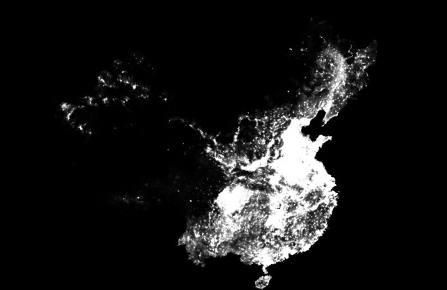
中文(中国大陆):乡镇(街道)级人口统计数据是中国目前公开的最精细的人口统计数据。将人口统计数据和行政边界数据进行属性关联,实现人口统计数据的空间展布,对于支持地理、资源、环境、生态、灾害,以及可持续发展等方面的研究具有重要意义。本数据集将2010年国家统计局发布的中国31个省(直辖市、自治区)的乡镇(街道)单元人口统计数据按乡镇行政区划建立空间匹配,经过拓扑处理、属性匹配、人口密度计算和矢栅转换,形成2010年乡镇(街道)级人口密度数据集,数据集为TIFF栅格形式。 English: Township-level demographic data is the most detailed data released in China currently. Associating the attribute table of demographic data with the one of administrative boundary data to realize spatial distribution of population, is significant to the research of geography, resources, environment, ecology, disasters, sustainable development, etc. This dataset establishes spatial matching of administrative divisions to township level demographic data released by National Bureau of Statistics in 2010 covering 31 provinces, municipalities, and autonomous regions in China. Through topology processing, attribute matching, population density calculation and vector grid conversion, the township-level population density dataset of China (2010) was formed in the TIFF format. |
| Date | |
| Source | 王卷乐;王晓洁;王明明;姚锦一;王岚涛;邱丛丛 (2020). 中国乡镇(街道)人口密度数据集(2010年). Science Data Bank. http://www.dx.doi.org/10.11922/sciencedb.964 |
| Author | 王卷乐, 王晓洁, 王明明, 姚锦一, 王岚涛, 邱丛丛 |
Licensing
[edit]| This file is made available under the Creative Commons CC0 1.0 Universal Public Domain Dedication. | |
| The person who associated a work with this deed has dedicated the work to the public domain by waiving all of their rights to the work worldwide under copyright law, including all related and neighboring rights, to the extent allowed by law. You can copy, modify, distribute and perform the work, even for commercial purposes, all without asking permission.
|
File history
Click on a date/time to view the file as it appeared at that time.
| Date/Time | Thumbnail | Dimensions | User | Comment | |
|---|---|---|---|---|---|
| current | 01:04, 9 May 2020 |  | 6,575 × 4,279 (108.98 MB) | Njzjz (talk | contribs) | Uploaded a work by 王卷乐, 王晓洁, 王明明, 姚锦一, 王岚涛, 邱丛丛 from 王卷乐;王晓洁;王明明;姚锦一;王岚涛;邱丛丛 (2020). 中国乡镇(街道)人口密度数据集(2010年). Science Data Bank. http://www.dx.doi.org/10.11922/sciencedb.964 with UploadWizard |
You cannot overwrite this file.
File usage on Commons
There are no pages that use this file.
File usage on other wikis
The following other wikis use this file:
- Usage on fr.wikipedia.org
- Usage on ja.wikipedia.org
- Usage on ru.wikipedia.org
- Usage on zh.wikipedia.org