File:【国土地理院】長野県長野市大字赤沼付近の被害箇所.webm
Jump to navigation
Jump to search
Size of this JPG preview of this WEBM file: 800 × 450 pixels. Other resolutions: 320 × 180 pixels | 640 × 360 pixels | 1,024 × 576 pixels | 1,280 × 720 pixels | 1,920 × 1,080 pixels.
Original file (WebM audio/video file, VP8/Vorbis, length 9 min 51 s, 1,920 × 1,080 pixels, 11.79 Mbps overall, file size: 830.54 MB)
Captions
Captions
Add a one-line explanation of what this file represents
Summary
[edit]| Description |
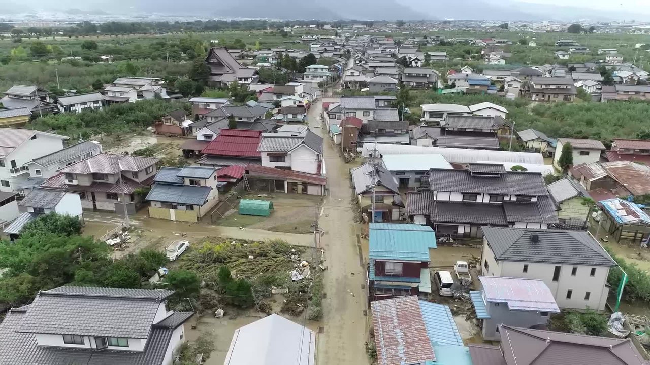
日本語: UAV(ドローン)で令和元年(2019年)10月13日長野県長野市で発生した千曲川の破堤に伴う被災状況を10月14日に撮影しました。 |
| Date | |
| Source | https://www.gsi.go.jp/BOUSAI/R1.taihuu19gou.html / https://www.youtube.com/watch?v=pHMAqahqECU |
| Author | 国土地理院 |
Licensing
[edit]
|
This work is licensed under the Government of Japan Standard Terms of Use (Ver.2.0). The Terms of Use are compatible with the Creative Commons Attribution License 4.0 International. For the terms of use of this work, see this license page.
|
This file is licensed under the Creative Commons Attribution 4.0 International license.
Attribution: 国土地理院ホームページ
- You are free:
- to share – to copy, distribute and transmit the work
- to remix – to adapt the work
- Under the following conditions:
- attribution – You must give appropriate credit, provide a link to the license, and indicate if changes were made. You may do so in any reasonable manner, but not in any way that suggests the licensor endorses you or your use.
>私はウィキペディアの投稿者で、貴院がYouTUbe上にアップロード下さいました以下動画群をウィキペディアに転載投稿したところライセンス違反の指摘を受け、現在削除依頼されております。
>
>YouTubeに投稿された下記動画群はYouTubeで任意に指定できるCCライセンスの表記がございませんが、こちらも国土地理院コンテンツ利用規約(https://www.gsi.go.jp/kikakuchousei/kikakuchousei40182.html )に従って、出典(貴院名と元となったURL)を明示することで、商用利用も可能という理解で相違ございませんでしょうか?
■回答は以下になります
お問い合わせいただきありがとうございます。
国土地理院HP上の基本測量以外のコンテンツについては、 出典明示で利用可能であることは、ご理解されている通りです。
ただし、ウィキペディアに転載することについては、先方の規約に基づいて行ってください。
以上よろしくお願いいたします。
File history
Click on a date/time to view the file as it appeared at that time.
| Date/Time | Thumbnail | Dimensions | User | Comment | |
|---|---|---|---|---|---|
| current | 04:28, 16 October 2019 | 9 min 51 s, 1,920 × 1,080 (830.54 MB) | 片割れ靴下 (talk | contribs) | c:User:Rillke/bigChunkedUpload.js: =={{int:filedesc}}== {{Information |description={{ja|1=UAV(ドローン)で令和元年(2019年)10月13日長野県長野市で発生した千曲川の破堤に伴う被災状況を10月14日に撮影しました。}} |date=2019-10-14 |source=https://www.youtube.com/watch?v=pHMAqahqECU |author=国土地理院 |permission= |other versions= }} =={{int:license-header}}== {{cc-by-sa-4.0}} >私はウィキペディアの投稿者で、貴院がYouTUbe上にアップロード下さいました以下動画群をウィキペディアに転載投稿したところライセンス違反の指摘を受け、現在削除依頼されております。 > >YouTubeに投稿された下記動画群はYouTubeで任意に指定できるCCライセンスの表記がございませんが、こちらも国土地理院コンテンツ利用規約(ht... |
You cannot overwrite this file.
File usage on Commons
There are no pages that use this file.