File:“Map Five; The Mackay district, 1877”, in; Clive R. Moore, Kanaka Maratta; A History of Melanesian Mackay, PhD thesis, James Cook University of North Queensland, 1981, p. 218. — Vectorization by Vincent Mia Edie Verheyen (2018).svg
Jump to navigation
Jump to search

Size of this PNG preview of this SVG file: 494 × 599 pixels. Other resolutions: 198 × 240 pixels | 396 × 480 pixels | 633 × 768 pixels | 845 × 1,024 pixels | 1,689 × 2,048 pixels | 843 × 1,022 pixels.
Original file (SVG file, nominally 843 × 1,022 pixels, file size: 329 KB)
Captions
Captions
Add a one-line explanation of what this file represents
Summary
[edit]| Description |
English: “Map Five: The Mackay district, 1877”, in: Clive Robert Moore, Kanaka Maratta: A History of Melanesian Mackay, PhD thesis, James Cook University of North Queensland, 1981, Vol. 1, p. 218. — Vectorization by Vincent Mia Edie Verheyen (2018).
For an upcoming book of Emeritus Professor Emeritus Professor Clive Moore with interim title “The River: Port Mackay in the Nineteenth Century” (estimated to be published 2019—2021).
Text included in this image[Date]
[Legend]
[Main text]
|
| Date | |
| Source | Own work |
| Author | Vincent Mia Edie Verheyen (cartographer) & Emeritus Professor Clive Moore (instructions for change vis-à-vis the original 1981 map) |
| Other versions |
This file was derived from: 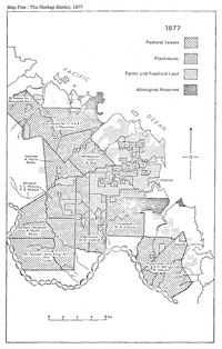 “Map Five; The Mackay district, 1877”, in; Clive Robert Moore, Kanaka Maratta; A History of Melanesian Mackay, PhD thesis, James Cook University of North Queensland, 1981, Vol. 1, p. 218.pdf “Map Five; The Mackay district, 1877”, in; Clive Robert Moore, Kanaka Maratta; A History of Melanesian Mackay, PhD thesis, James Cook University of North Queensland, 1981, Vol. 1, p. 218.pdf |
| Attribution (required by the license) | 2018 © Vincent Mia Edie Verheyen (cartographer) & Emeritus Professor Clive Moore (instructions for change vis-à-vis the original 1981 map) / Derived from “Map Five: The Mackay district, 1877”, in: Clive Robert Moore, Kanaka Maratta; A History of Melanesian Mackay, PhD thesis, James Cook University of North Queensland, 1981, Vol. 1, p. 218 / |
File validation
[edit]This vector image was created with Adobe Illustrator by v.
Licensing
[edit]I, the copyright holder of this work, hereby publish it under the following license:
This file is licensed under the Creative Commons Attribution-Share Alike 4.0 International license.
- You are free:
- to share – to copy, distribute and transmit the work
- to remix – to adapt the work
- Under the following conditions:
- attribution – You must give appropriate credit, provide a link to the license, and indicate if changes were made. You may do so in any reasonable manner, but not in any way that suggests the licensor endorses you or your use.
- share alike – If you remix, transform, or build upon the material, you must distribute your contributions under the same or compatible license as the original.
See also
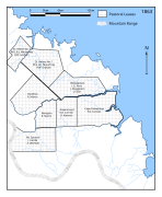
[edit]You are currently on the page of the file “Map Five: The Mackay district, 1877 ...”. See also, in the same series:
-
 “Map
“Map
Three:
The Mackay district,
1863 ...” -
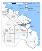 “Map
“Map
Four:
The Mackay district,
1869 ...” -
 “Map
“Map
Six:
The Mackay district,
1883 ...”
.svg)
.svg)
.svg)
.svg&action=edit§ion=1)
.svg&action=edit§ion=6)
.svg&action=edit§ion=7)
.svg&action=edit§ion=8)
File history
Click on a date/time to view the file as it appeared at that time.
| Date/Time | Thumbnail | Dimensions | User | Comment | |
|---|---|---|---|---|---|
| current | 15:10, 31 July 2018 | | 843 × 1,022 (329 KB) | Vanished user lkjhgfdsazxcvbnm (talk | contribs) | Minor changes to styling for congruence with File:“Map Six; The Mackay district, 1883”, in; Clive R. Moore, Kanaka Maratta; A History of Melanesian Mackay, PhD thesis, James Cook University of North Queensland, 1981, p. 228. — Vectorization by Vincent Mia Edie Verheyen (2018).svg |
| 11:43, 31 July 2018 |  | 843 × 1,022 (464 KB) | Vanished user lkjhgfdsazxcvbnm (talk | contribs) | Added some extra rivers based on https://commons.wikimedia.org/wiki/File:“Map Six; The Mackay district, 1883”, in; Clive R. Moore, Kanaka Maratta; A History of Melanesian Mackay, PhD thesis, James Cook University of North Queensland, 1981, p. 228. — Vectorization by Vincent Mia Edie Verheyen (2018).svg | |
| 14:15, 27 July 2018 |  | 843 × 1,022 (464 KB) | Vanished user lkjhgfdsazxcvbnm (talk | contribs) | Added meta-data. Corrected "G Turnor" into "G. Turnor". | |
| 13:56, 27 July 2018 |  | 843 × 1,022 (458 KB) | Vanished user lkjhgfdsazxcvbnm (talk | contribs) | User created page with UploadWizard |
You cannot overwrite this file.
File usage on Commons
The following 5 pages use this file:
- File:“Map Five; The Mackay district, 1877”, in; Clive Robert Moore, Kanaka Maratta; A History of Melanesian Mackay, PhD thesis, James Cook University of North Queensland, 1981, Vol. 1, p. 218.pdf
- File:“Map Four; The Mackay district, 1869”, in; Clive R. Moore, Kanaka Maratta; A History of Melanesian Mackay, PhD thesis, James Cook University of North Queensland, 1981, p. 203. — Vectorization by Vincent Mia Edie Verheyen (2018).svg
- File:“Map Six; The Mackay district, 1883”, in; Clive R. Moore, Kanaka Maratta; A History of Melanesian Mackay, PhD thesis, James Cook University of North Queensland, 1981, p. 228. — Vectorization by Vincent Mia Edie Verheyen (2018).svg
- File:“Map Thirteen; The Mackay district, 1877”, in; Clive Moore, Kanaka; A History of Melanesian Mackay, Port Moresby, Institute of Papua New Guinea Studies and University of Papua New Guinea Press, 1985, p. 110.pdf
- File:“Map Three; The Mackay district, 1863”, in; Clive R. Moore, Kanaka Maratta; A History of Melanesian Mackay, PhD thesis, James Cook University of North Queensland, 1981, p. 191. — Vectorization by Vincent Mia Edie Verheyen (2018).svg
.svg&oldid=603694171)