File:Холокост в Европе.svg

Original file (SVG file, nominally 1,310 × 1,090 pixels, file size: 1.38 MB)
Captions
Captions
Summary
[edit]
| Description |
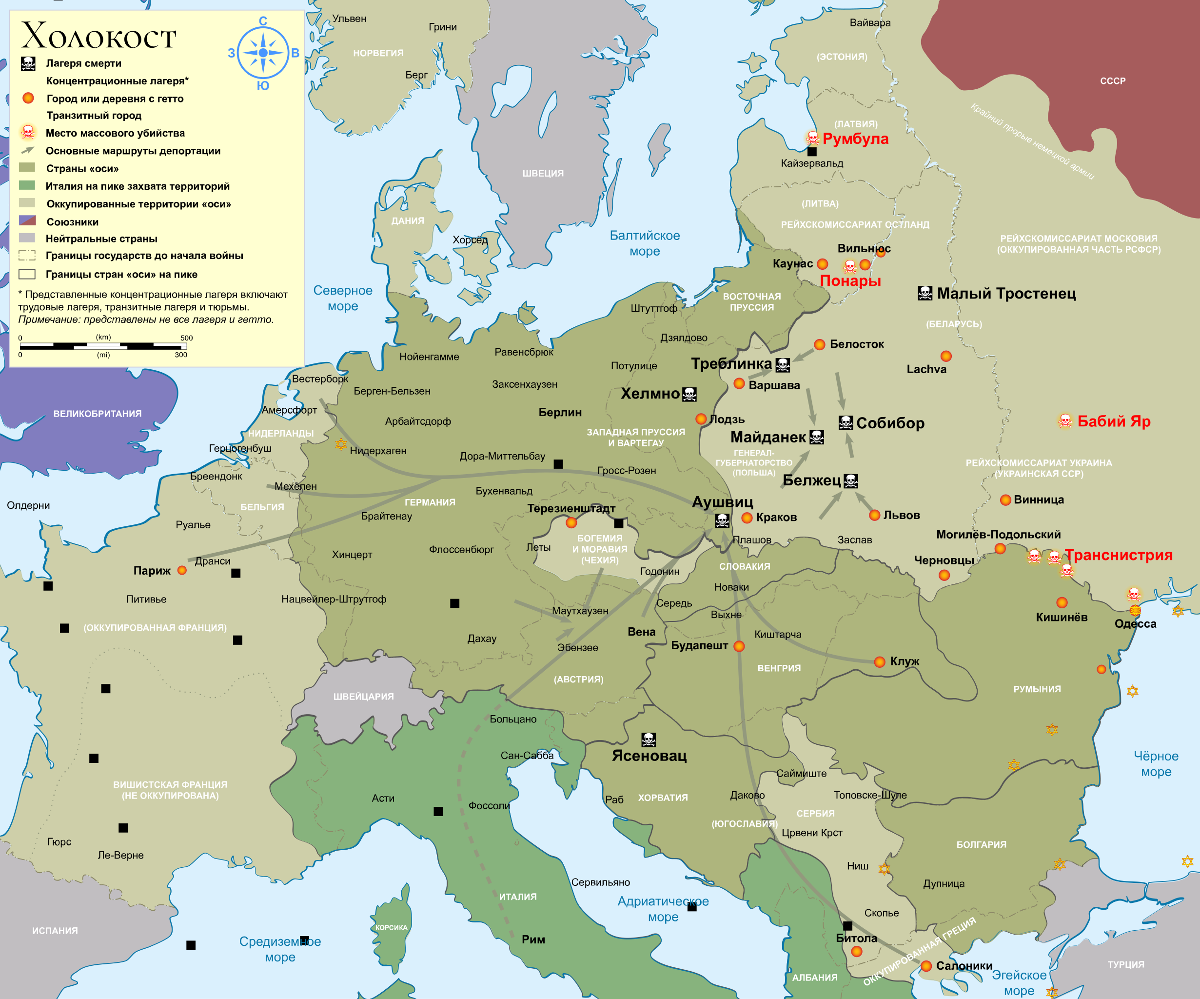
English: English: Map of the Holocaust in Europe during World War II, 1939-1945.
This map shows all extermination camps (or death camps), most major concentration camps, labor camps, prison camps, ghettos, major deportation routes and major massacre sites. Notes: Extermination camps were dedicated death camps, but all camps and ghettos took a toll of many, many lives. Concentration camps include labor camps, prison camps & transit camps. Not all camps & ghettos are shown. Borders are at the height of Axis domination (1942) and before the war (1920) Some regions have German designations (e.g. "Ostmark"), with the present country name denoted in uppercase letters in parenthesis below the German designation (e.g. "(Austria)").Русский: Русский: Карта Холокоста в Европе во время Второй мировой войны, 1939-1945.
На этой карте показаны все лагеря смерти, большинство крупных концентрационных лагерей, трудовых лагерей, лагерей для военнопленных, гетто, основные маршруты депортации и основные места массовых убийств. Пояснения: Лагеря смерти были специализированными лагерями уничтожения людей, но все лагеря и гетто унесли много-много жизней. Концентрационные лагеря включают трудовые лагеря, лагеря для военнопленных и транзитные лагеря. Показаны не все лагеря и гетто. Границы показаны на пике господства стран «оси» (1942) и до начала войны (1920) Некоторые регионы имеют немецкие обозначения (например, «Рейхскомиссариат Остланд»), при этом название страны обозначается заглавными буквами в скобках под немецким обозначением (например, «(Литва)»). |
| Date | |
| Source | https://commons.wikimedia.org/wiki/File:WW2_Holocaust_Europe_map-fr.svg |
| Author |
WW2-Holocaust-Europe.png: User:Dna-Dennis derivative work: Fargoh |
Licensing
[edit]
- You are free:
- to share – to copy, distribute and transmit the work
- to remix – to adapt the work
- Under the following conditions:
- attribution – You must give appropriate credit, provide a link to the license, and indicate if changes were made. You may do so in any reasonable manner, but not in any way that suggests the licensor endorses you or your use.
- share alike – If you remix, transform, or build upon the material, you must distribute your contributions under the same or compatible license as the original.
File history
Click on a date/time to view the file as it appeared at that time.
| Date/Time | Thumbnail | Dimensions | User | Comment | |
|---|---|---|---|---|---|
| current | 01:18, 28 March 2023 | | 1,310 × 1,090 (1.38 MB) | Fargoh (talk | contribs) | Исправления |
| 01:14, 28 March 2023 |  | 1,310 × 1,090 (321 KB) | Fargoh (talk | contribs) | Uploaded a work by WW2-Holocaust-Europe.png: User:Dna-Dennis derivative work: Fargoh from https://commons.wikimedia.org/wiki/File:WW2_Holocaust_Europe_map-fr.svg with UploadWizard |
You cannot overwrite this file.
File usage on Commons
The following page uses this file: