File:Закавказский край (1809―1817).jpg

Original file (8,466 × 6,300 pixels, file size: 9.48 MB, MIME type: image/jpeg)
Captions
Captions
Summary
[edit]| Description |
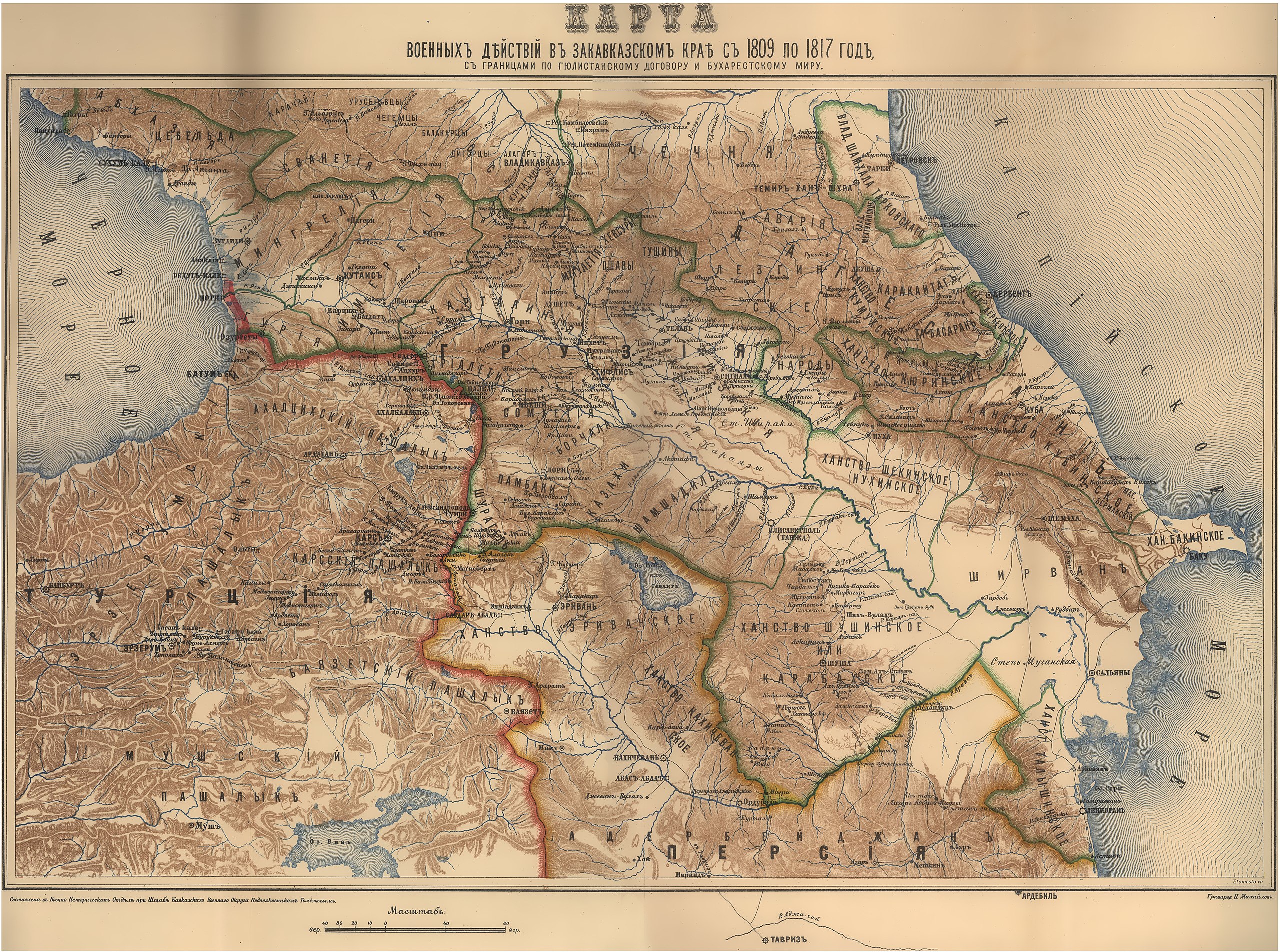
Русский: Карта военных действий в Закавказском крае с 1809 по 1817 год, с границами по Гюлистанскому договору и Бухарестскому миру. |
| Date | before 1902 |
| Source |
Книга «Утверждение русского владычества на Кавказе», том 2.
|
| Author | Владимир Ильич Томкеев |
| Other versions |
_(cropped).jpg)
.jpg&action=edit§ion=1)
Licensing
[edit].jpg&action=edit§ion=2)
This work was published on territory of the Russian Empire (Russian Republic) except for territories of the Grand Duchy of Finland and Congress Poland before 7 November 1917 and wasn't re-published for 30 days following initial publications on the territory of Soviet Russia or any other countries.
The Russian Federation (early Soviet Russia, RSFSR) is the historical heir but not legal successor of the Russian Empire, and the Russian Empire was not party to the Berne Convention (it was not country of Union for the protection of the rights of authors in their literary and artistic works), so according to article 5 of the Convention this work has no country of origin except:
¹ - Author who is not a national of a country of the Union but who has his habitual residence in a country of the Union, be assimilated to national of that country. The exclusive rights to this work do not extend on territory of the Russian Federation according to article 1256 of the Civil Code of the Russian Federation (details), because this work does not meet the requirements on the territory of publication, on the author's nationality, and on obligations for international treaties. If applicable, {{PD-Russia-expired}} should be used instead of this tag. This work is in the public domain in the United States because it was published (or registered with the U.S. Copyright Office) before January 1, 1929. |
 |
File history
Click on a date/time to view the file as it appeared at that time.
| Date/Time | Thumbnail | Dimensions | User | Comment | |
|---|---|---|---|---|---|
| current | 07:33, 19 March 2016 | | 8,466 × 6,300 (9.48 MB) | Sabuhi from Baku (talk | contribs) | large version: updating |
| 05:27, 19 January 2016 |  | 4,213 × 2,905 (5.88 MB) | Игорь(Питер) (talk | contribs) | User created page with UploadWizard |
You cannot overwrite this file.
File usage on Commons
The following page uses this file:
File usage on other wikis
The following other wikis use this file:
- Usage on fa.wikipedia.org
- Usage on ka.wikipedia.org
- Usage on ru.wikipedia.org
- Usage on uz.wikipedia.org
Metadata
.jpg&oldid=867713257)
- Old maps of Russia
- Military maps of the Russian Empire
- Maps of the history of the Caucasus under Russian rule
- Maps of the history of the Caucasus
- Adoption of Russian rule at the Caucasus
- Maps by Vladimir Tomkeev
- Maps of Viceroyalty of the Caucasus
- 19th-century maps of Azerbaijan
- Old maps of Khanates of the South Caucasus
- Maps of Georgia Governorate