Category:Maps by Vladimir Tomkeev
Jump to navigation
Jump to search
Media in category "Maps by Vladimir Tomkeev"
The following 12 files are in this category, out of 12 total.
-
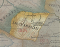
 Abkhazia in the Map of Caucasus with the borders 1801-1813.JPG 939 × 686; 641 KB
-
 Khanate of Baku in the Map of Caucasus with the borders.jpg 3,000 × 3,819; 3.26 MB
-
 Khanate of Ganja in the Map of Caucasus with the borders 1801-1813.png 561 × 446; 526 KB
-
 Khanate of Guba in the Map of Caucasus with the borders 1801-1813.png 814 × 796; 1.27 MB
-
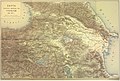
 Khanate of Karabakh in the Map of Caucasus with the borders 1801-1813.png 992 × 939; 1.45 MB
-
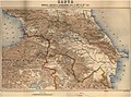
 Khanate of Shirvan in the Map of Caucasus with the borders.jpg 2,200 × 2,921; 2.23 MB
-
 Map of Caucasus with the borders 1801-1813.JPG 4,936 × 4,049; 7.92 MB
-
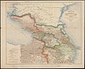
 Закавказский край (1809―1817) (cropped).jpg 1,033 × 650; 273 KB
-
 Закавказский край (1809―1817).jpg 8,466 × 6,300; 9.48 MB
-
 Карта войны с Персией (1826―1828).jpg 6,340 × 7,200; 64.24 MB
-
 Карта войны с Турцией (1828―1829).jpg 6,936 × 4,657; 50.48 MB
-
 Карта Кавказского края (1801-1813)..jpg 4,417 × 3,641; 7.6 MB


_(cropped).jpg)
.jpg)
.jpg)
.jpg)
..jpg)