File:Геогностическая карта Европейской России и хребта Уральскаго.pdf
Jump to navigation
Jump to search

Size of this JPG preview of this PDF file: 800 × 595 pixels. Other resolutions: 320 × 238 pixels | 640 × 476 pixels | 1,024 × 761 pixels | 1,280 × 951 pixels | 2,560 × 1,903 pixels | 5,039 × 3,745 pixels.
Original file (5,039 × 3,745 pixels, file size: 7.83 MB, MIME type: application/pdf)
Captions
Captions
Add a one-line explanation of what this file represents
Summary
[edit]| Description |
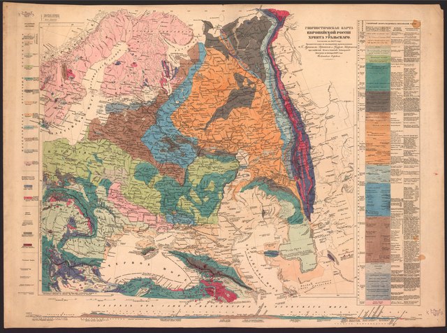
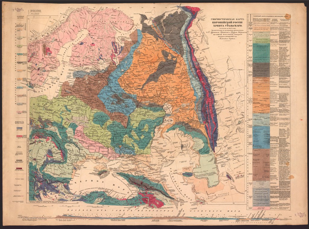
Русский: Геогностическая карта Европейской России и хребта Уральскаго : составлена в 1845 году предпочтительно по наблюдениям, произведённым гг. Мурчисоном, Вернейлем и графом Кейзерлингом при содействии штабс-капитана Кокшарова 1-го : дополнена по октябрь 1849 года полковником Озерским
Мурчисон, 1792-1871 (Родерик Импи); Вернёй, Пуллетье де, Филипп Эдуард (1805-1873); Кейзерлинг, Александр Андреевич (1815-1891); Озёрский, Александр Дмитриевич (1814-1880) после 1849 |
| Date | после 1849 |
| Source | https://vivaldi.nlr.ru/cm000010585/details |
| Author | Мурчисон Р.И., Вернейль Э., Кайзерлинг А. |
Licensing
[edit]|
This work is in the public domain in its country of origin and other countries and areas where the copyright term is the author's life plus 70 years or fewer. This work is in the public domain in the United States because it was published (or registered with the U.S. Copyright Office) before January 1, 1929. | |
| This file has been identified as being free of known restrictions under copyright law, including all related and neighboring rights. | |
File history
Click on a date/time to view the file as it appeared at that time.
| Date/Time | Thumbnail | Dimensions | User | Comment | |
|---|---|---|---|---|---|
| current | 15:35, 12 August 2022 |  | 5,039 × 3,745 (7.83 MB) | Wlbw68 (talk | contribs) | Uploaded a work by Мурчисон Р.И., Вернейль Э., Кайзерлинг А. from https://vivaldi.nlr.ru/cm000010585/details with UploadWizard |
You cannot overwrite this file.
File usage on Commons
The following 2 pages use this file: