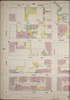
File:"Pump House for Breweries" (George Ehret Brewery and Jacob Ruppert Brewery) corner of E. 93rd St. (top) across from the Ferry Terminal to Astoria 1896 map - Sanborn Fire Insurance Map - New York City. LOC sanborn06116 009-19 (cropped).tif
Jump to navigation
Jump to search

Size of this JPG preview of this TIF file: 800 × 600 pixels. Other resolutions: 320 × 240 pixels | 640 × 480 pixels | 1,024 × 768 pixels | 1,280 × 960 pixels | 2,260 × 1,695 pixels.
Original file (2,260 × 1,695 pixels, file size: 10.96 MB, MIME type: image/tiff)
Captions
Captions
Add a one-line explanation of what this file represents
Summary
[edit]| Description |
English: 1890 - 1902 Vol. 8, 1896. 55 Sheet(s). Key map to edition. Double-paged plates numbered 153-178. Bound. |
||
| Title | Sanborn Fire Insurance Map from New York, Bronx, Kings, Queens, Richmond, New York. | ||
| Shelf ID | https://www.loc.gov/item/sanborn06116_009/ | ||
| Parent | https://www.loc.gov/resource/g3804nm.g3804nm_g06116189608/ | ||
| Sheet title | Image 19 of Sanborn Fire Insurance Map from New York, Bronx, Kings, Queens, Richmond, New York. | ||
| Date | |||
| Source | https://www.loc.gov/item/sanborn06116_009/ | ||
| Author | Unknown author | ||
| Permission (Reusing this file) |
|
||
| Other versions |
|
||
| Location | Bronx · Kings · New York · Richmond · Queens | ||
| Part of | American Memory · Sanborn Maps · Geography And Maps Division · Sanborn Fire Insurance Maps |


Licensing
[edit]|
This is a faithful photographic reproduction of a two-dimensional, public domain work of art. The work of art itself is in the public domain for the following reason:
The official position taken by the Wikimedia Foundation is that "faithful reproductions of two-dimensional public domain works of art are public domain".
This photographic reproduction is therefore also considered to be in the public domain in the United States. In other jurisdictions, re-use of this content may be restricted; see Reuse of PD-Art photographs for details. | ||||
File history
Click on a date/time to view the file as it appeared at that time.
| Date/Time | Thumbnail | Dimensions | User | Comment | |
|---|---|---|---|---|---|
| current | 05:45, 19 May 2021 |  | 2,260 × 1,695 (10.96 MB) | Ooligan (talk | contribs) | File:Sanborn Fire Insurance Map from New York, Bronx, Kings, Queens, Richmond, New York. LOC sanborn06116 009-19.tif cropped 60 % horizontally, 79 % vertically using CropTool with lossless mode. |
You cannot overwrite this file.
File usage on Commons
The following 3 pages use this file: