| Name
|
Heritage list
|
Place
|
Street address
|
Coordinates
|
place_id
|
Image
|
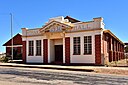
| Northam Police Station and Court House (Q66975762)
|
State Registered Place
|
Northam
|
|
31°39′25″S 116°40′09″E / 31.656951°S 116.669191°E / -31.656951; 116.669191
|
1890
|
|
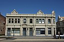
| Northam Post Office (Q38161313)
|
State Registered Place
|
Northam
|
|
31°39′18″S 116°40′13″E / 31.65513°S 116.670298°E / -31.65513; 116.670298
|
1867
|

|
| Northam Post Office (former) (Q66975764)
|
State Registered Place
|
Northam
|
|
31°39′09″S 116°40′29″E / 31.652412945798°S 116.67476003141044°E / -31.652412945797625; 116.67476003141044
|
1892
|
|
| Northam Railway Station (former) (Q66975765)
|
State Registered Place
|
Northam
|
|
31°39′39″S 116°39′46″E / 31.660893°S 116.662742°E / -31.660893; 116.662742
|
1859
|

|
| Northam Senior High School (Q7057569)
|
State Registered Place
|
|
|
31°38′49″S 116°40′05″E / 31.647025°S 116.668159°E / -31.647025; 116.668159
|
1883
|
|
| Northam State School (Q66975767)
|
State Registered Place
|
Northam
|
|
31°39′07″S 116°40′30″E / 31.651925°S 116.675101°E / -31.651925; 116.675101
|
1881
|
|
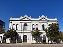
| Northam Town Hall/Lesser Hall (Q66975769)
|
State Registered Place
|
Northam
|
|
31°39′22″S 116°40′18″E / 31.656213°S 116.671634°E / -31.656213; 116.671634
|
1877
|
|
| Northampton Police Station, Quarters & Court House (Q66975770)
|
State Registered Place
|
Northampton
|
|
28°21′06″S 114°37′51″E / 28.351615°S 114.630926°E / -28.351615; 114.630926
|
1906
|
|
| Northampton Railway Station Precinct (Q66975773)
|
State Registered Place
|
Northampton
|
|
28°21′01″S 114°38′06″E / 28.350225°S 114.635107°E / -28.350225; 114.635107
|
1911
|
|
| Northampton Railway Station and Rest Room (Q66975772)
|
State Registered Place
|
Northampton
|
|
28°20′57″S 114°38′08″E / 28.349285°S 114.635506°E / -28.349285; 114.635506
|
17859
|
|
| Northampton Roads Board Building (Q66975775)
|
State Registered Place
|
Northampton
|
|
28°21′05″S 114°37′48″E / 28.35146°S 114.630092°E / -28.35146; 114.630092
|
1907
|
|
| Northampton State Battery (Q56053615)
|
State Registered Place
|
|
|
28°21′24″S 114°36′54″E / 28.35667044°S 114.6148845°E / -28.35667044; 114.6148845
|
5114
|
|
| Norwegian Bay Whaling Station (Q56053616)
|
State Registered Place
|
|
|
22°35′36″S 113°40′23″E / 22.59335224°S 113.6729497°E / -22.59335224; 113.6729497
|
4231
|
|
| Nulsen Haven (Q56053617)
|
State Registered Place
|
Ascot
|
|
31°55′34″S 115°57′03″E / 31.92616244°S 115.9508432°E / -31.92616244; 115.9508432
|
140
|
|
| Nungarin Roads Board Office (fmr) (Q56053618)
|
State Registered Place
|
|
|
31°11′07″S 118°06′04″E / 31.18522061°S 118.1011689°E / -31.18522061; 118.1011689
|
1919
|

|
| Nurses Memorial Centre (Q56053619)
|
State Registered Place
|
West Perth
|
|
31°57′07″S 115°50′19″E / 31.95188601°S 115.8386855°E / -31.95188601; 115.8386855
|
2665
|

|
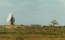
| OTC Satellite Earth Station Carnarvon (Q7073081)
|
State Registered Place
|
Carnarvon
|
|
24°52′08″S 113°42′14″E / 24.868961°S 113.703928°E / -24.868961; 113.703928
|
472
|
|
| Oakabella (Q56053620)
|
State Registered Place
|
|
|
28°30′01″S 114°35′52″E / 28.50036329°S 114.5979105°E / -28.50036329; 114.5979105
|
3271
|
|
| Oakover (Q56053621)
|
State Registered Place
|
Middle Swan
|
|
31°51′02″S 115°59′57″E / 31.85053673°S 115.9990907°E / -31.85053673; 115.9990907
|
2495
|
|
| Oakover Homestead (Q56053622)
|
State Registered Place
|
Middle Swan
|
|
31°51′02″S 115°59′56″E / 31.85049447°S 115.9987876°E / -31.85049447; 115.9987876
|
24507
|
|
| Oakover Winery - Barn (Q66975777)
|
State Registered Place
|
Middle Swan
|
|
31°51′03″S 115°59′58″E / 31.850774°S 115.999418°E / -31.850774; 115.999418
|
23568
|
|
| Oakover Winery - Shed (Q66975778)
|
State Registered Place
|
Middle Swan
|
|
31°51′01″S 115°59′56″E / 31.850243°S 115.998944°E / -31.850243; 115.998944
|
23575
|
|
| Oakover Winery - Stable (Q66975780)
|
State Registered Place
|
Middle Swan
|
|
31°51′01″S 115°59′57″E / 31.8504°S 115.99926°E / -31.8504; 115.99926
|
23563
|
|
| Ocean View (Q28378415)
|
State Registered Place
|
Beaconsfield
|
|
32°03′52″S 115°45′36″E / 32.064452°S 115.760001°E / -32.064452; 115.760001
|
1033
|

|
| Oceanic Hotel (Q28225106)
|
State Registered Place
|
|
|
32°03′25″S 115°44′45″E / 32.056812°S 115.745904°E / -32.056812; 115.745904
|
862
|

|
| Oddfellows Hall, Leederville (Q66975784)
|
State Registered Place
|
Leederville
|
|
31°56′01″S 115°50′27″E / 31.933628°S 115.840938°E / -31.933628; 115.840938
|
8736
|

|
| Office/Residence, 16–18 Cliff Street (Q66975785)
|
State Registered Place
|
Fremantle
|
|
32°03′21″S 115°44′34″E / 32.055972°S 115.742805°E / -32.055972; 115.742805
|
22919
|

|
| Offices and Dental Surgery (Q66975789)
|
State Registered Place
|
Kalgoorlie
|
|
30°44′44″S 121°28′16″E / 30.74555°S 121.471102°E / -30.74555; 121.471102
|
1270
|
|
| Offices, 41 Carnarvon Street, Broome (Q66975787)
|
State Registered Place
|
Broome
|
|
17°57′22″S 122°14′35″E / 17.956158°S 122.243083°E / -17.956158; 122.243083
|
16828
|
|
| Old Bank Row (Q66975793)
|
State Registered Place
|
Fremantle
|
|
32°03′25″S 115°44′44″E / 32.057051°S 115.745625°E / -32.057051; 115.745625
|
4583
|
|
| Old Blythewood (Q66975794)
|
State Registered Place
|
Blythewood
|
|
32°39′44″S 115°52′00″E / 32.662117°S 115.866734°E / -32.662117; 115.866734
|
1763
|

|
| Old Bunbury railway station (Q4997430)
|
State Registered Place
|
Bunbury
|
|
33°19′27″S 115°38′19″E / 33.324291°S 115.638682°E / -33.324291; 115.638682
|
331
|

|
| Old Butter Factory (Q66975801)
|
State Registered Place
|
Busselton
|
|
33°39′10″S 115°20′59″E / 33.652703°S 115.34986°E / -33.652703; 115.34986
|
3568
|

|
| Old Cable Station (Q66975803)
|
State Registered Place
|
Cottesloe
|
|
32°00′58″S 115°45′09″E / 32.016181°S 115.752464°E / -32.016181; 115.752464
|
4586
|

|
| Old Chapel (Q71267069)
|
State Registered Place
|
|
|
31°59′46″S 115°32′23″E / 31.996061°S 115.539669°E / -31.996061; 115.539669
|
523
|

|
| Old Claremont Fire Station (Q56052612)
|
State Registered Place
|
Claremont
|
|
31°59′15″S 115°46′12″E / 31.9874324°S 115.7699249°E / -31.9874324; 115.7699249
|
2664
|

|
| Old Council Offices (Q66975805)
|
State Registered Place
|
South Perth
|
|
31°58′24″S 115°51′08″E / 31.973452°S 115.852126°E / -31.973452; 115.852126
|
2393
|

|
| Old Court House & Gaol (Q66975808)
|
State Registered Place
|
Perth
|
|
31°56′59″S 115°51′43″E / 31.949675°S 115.861906°E / -31.949675; 115.861906
|
1965
|

|
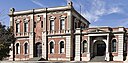
| Old Court House, Perth (Q7083777)
|
State Registered Place
|
Perth
|
|
31°57′27″S 115°51′38″E / 31.9576°S 115.8605°E / -31.9576; 115.8605
|
1948
|

|
| Old Dam (Q66975810)
|
State Registered Place
|
Leonora
|
|
28°46′29″S 121°18′09″E / 28.774769°S 121.302427°E / -28.774769; 121.302427
|
10954
|
|
| Old East End (Q66975811)
|
State Registered Place
|
Dongara
|
|
29°15′06″S 114°57′30″E / 29.251732°S 114.958268°E / -29.251732; 114.958268
|
1217
|

|
| Old Fairholme (Q66975814)
|
State Registered Place
|
Guildford
|
|
31°53′54″S 115°57′43″E / 31.898221°S 115.962023°E / -31.898221; 115.962023
|
2467
|
|
| Old Fremantle Customs House (Q14935795)
|
State Registered Place
|
Fremantle
|
|
32°03′17″S 115°44′32″E / 32.054649°S 115.742359°E / -32.054649; 115.742359
|
977
|

|
| Old Fremantle Fire Station (Q5501481)
|
State Registered Place
|
|
|
32°03′15″S 115°44′35″E / 32.054066°S 115.743144°E / -32.054066; 115.743144
32°03′15″S 115°44′35″E / 32.054138°S 115.743087°E / -32.054138; 115.743087
|
982
|

|
| Old Fremantle Workers' Club Building (Q86620915)
|
State Registered Place
|
|
|
32°03′18″S 115°44′38″E / 32.054919444444°S 115.74378888888889°E / -32.054919444444444; 115.74378888888889
|
4220
|

|
| Old Gaol (Q66975815)
|
State Registered Place
|
Cue
|
|
27°25′17″S 117°53′57″E / 27.421419°S 117.899105°E / -27.421419; 117.899105
|
628
|

|
| Old Gaol & Police Quarters, Bridgetown (Q56053647)
|
State Registered Place
|
|
|
33°57′27″S 116°08′16″E / 33.95736185°S 116.1377512°E / -33.95736185; 116.1377512
|
254
|

|
| Old Geraldton Gaol & Warder's Cottages (Q56053649)
|
State Registered Place
|
Geraldton
|
|
28°46′10″S 114°36′53″E / 28.76933122°S 114.614787°E / -28.76933122; 114.614787
|
13240
|
|
| Old Greenough Post Office (site of) (Q56053650)
|
State Registered Place
|
Greenough
|
|
28°56′37″S 114°44′40″E / 28.94351613°S 114.7443952°E / -28.94351613; 114.7443952
|
3728
|
|
| Old Halls Creek Post Office Ruins (Q56053651)
|
State Registered Place
|
|
|
18°14′55″S 127°46′59″E / 18.24863933°S 127.783153°E / -18.24863933; 127.783153
|
1173
|
|
| Old Hospital Complex (Q56053652)
|
State Registered Place
|
|
|
33°57′02″S 115°04′17″E / 33.95059546°S 115.0713423°E / -33.95059546; 115.0713423
|
3314
|
|
| Old Jarrah Tree (Q437976)
|
State Registered Place
|
Armadale
|
|
32°09′14″S 116°01′01″E / 32.154°S 116.017°E / -32.154; 116.017
|
9009
|

|
| Old Junction Bridge (Q56053653)
|
State Registered Place
|
|
|
31°18′10″S 115°36′27″E / 31.30273622°S 115.6075177°E / -31.30273622; 115.6075177
|
13064
|

|
| Old Junction Hotel (Q56053654)
|
State Registered Place
|
|
|
31°18′05″S 115°36′30″E / 31.30140654°S 115.6082871°E / -31.30140654; 115.6082871
|
1080
|

|
| Old Kalamunda Hotel (Q66975817)
|
State Registered Place
|
Kalamunda
|
|
31°58′19″S 116°03′35″E / 31.971962°S 116.059684°E / -31.971962; 116.059684
|
24787
|
|
| Old Kerosene Store (Q7084321)
|
State Registered Place
|
|
|
32°03′27″S 115°44′30″E / 32.05761206°S 115.7417123°E / -32.05761206; 115.7417123
|
846
|

|
| Old Methodist Church & Hall (Q66975819)
|
State Registered Place
|
Northam
|
|
31°39′26″S 116°40′20″E / 31.657178°S 116.672325°E / -31.657178; 116.672325
|
1856
|
|
| Old Midland Junction School (Q66975820)
|
State Registered Place
|
Midland
|
|
31°53′24″S 116°00′25″E / 31.890022°S 116.006864°E / -31.890022; 116.006864
|
2505
|
|
| Old Mill Theatre (Q66975824)
|
State Registered Place
|
South Perth
|
|
31°58′25″S 115°51′07″E / 31.973668°S 115.851962°E / -31.973668; 115.851962
|
2389
|

|
| Old Modernians War Memorial (Q110252341)
|
State Registered Place
|
|
|
31°56′41″S 115°50′17″E / 31.944756832843°S 115.83809370749742°E / -31.94475683284282; 115.83809370749742
|
15689
|

|
| Old Navy Club building (Q56053559)
|
State Registered Place
|
|
|
32°03′25″S 115°44′39″E / 32.05702325°S 115.7442134°E / -32.05702325; 115.7442134
|
3131
|
|
| Old Onslow Police Station (Q66975826)
|
State Registered Place
|
Onslow
|
|
21°42′44″S 114°56′53″E / 21.712216°S 114.947967°E / -21.712216; 114.947967
|
3949
|
|
| Old Onslow Townsite (Q66975828)
|
State Registered Place
|
Talandji
|
|
21°42′21″S 114°56′53″E / 21.705861°S 114.948023°E / -21.705861; 114.948023
|
3444
|
|
| Old Perth Boys School (Q7084722)
|
State Registered Place
|
|
|
31°57′15″S 115°51′16″E / 31.954304147589°S 115.85457392334428°E / -31.954304147589497; 115.85457392334428
|
2117
|

|
| Old Perth Central Fire Station (Q7084723)
|
State Registered Place
|
Perth
|
|
31°57′17″S 115°51′51″E / 31.954827989836°S 115.864287992407°E / -31.954827989836403; 115.864287992407
|
2051
|

|
| Old Perth Observatory (Q54117704)
|
State Registered Place
|
West Perth
|
|
31°57′09″S 115°50′40″E / 31.95245°S 115.84451°E / -31.95245; 115.84451
|
2240
|

|
| Old Perth Technical School (Q7084724)
|
State Registered Place
|
Perth
|
|
31°57′16″S 115°51′17″E / 31.95441°S 115.85483°E / -31.95441; 115.85483
|
2116
|

|
| Old Police Buildings (Q66975829)
|
State Registered Place
|
Beverley
|
|
32°06′29″S 116°55′42″E / 32.108122°S 116.928199°E / -32.108122; 116.928199
|
24398
|
|
| Old Police Lockup & Boab Tree (Q66975831)
|
State Registered Place
|
Broome
|
|
17°57′22″S 122°14′33″E / 17.955974°S 122.242515°E / -17.955974; 122.242515
|
294
|
|
| Old Police Quarters, Guildford (Q106540942)
|
State Registered Place
|
|
|
31°53′54″S 115°58′19″E / 31.898258168915°S 115.97193670269318°E / -31.898258168915103; 115.97193670269318
|
23554
|

|
| Old Primary School, Southern Cross (Q66975833)
|
State Registered Place
|
Southern Cross
|
|
31°13′50″S 119°19′36″E / 31.230552°S 119.326758°E / -31.230552; 119.326758
|
10022
|
|
| Old Pumping Station (Q66975834)
|
State Registered Place
|
Wallaroo
|
|
31°05′34″S 120°41′36″E / 31.092729°S 120.693253°E / -31.092729; 120.693253
|
583
|
|
| Old Sikh Cemetery (Q66975198)
|
State Registered Place
|
Ferndale
|
|
32°02′01″S 115°54′34″E / 32.033628°S 115.90941°E / -32.033628; 115.90941
|
4612
|

|
| Old South Fremantle Post Office (Q66976258)
|
State Registered Place
|
South Fremantle
|
|
32°03′58″S 115°45′28″E / 32.066005°S 115.757649°E / -32.066005; 115.757649
|
1045
|

|
| Old Store (Q66975836)
|
State Registered Place
|
Greenough
|
|
28°56′38″S 114°44′43″E / 28.94394°S 114.745175°E / -28.94394; 114.745175
|
1152
|
|
| Old Tang Wei Cafe & Residence (Q66975839)
|
State Registered Place
|
Broome
|
|
17°57′15″S 122°14′35″E / 17.954171°S 122.242933°E / -17.954171; 122.242933
|
15879
|
|
| Old Tillellan (Piesse's) Shearing Quarters (Q66975841)
|
State Registered Place
|
Arthur River
|
|
33°20′47″S 117°02′20″E / 33.346486°S 117.038819°E / -33.346486; 117.038819
|
23459
|

|
| Old Tillellan (Piesse's) Shearing Shed (Q66975842)
|
State Registered Place
|
Arthur River
|
|
33°20′48″S 117°02′17″E / 33.346768°S 117.03811°E / -33.346768; 117.03811
|
23458
|

|
| Old Toodyay Court House (Q16901879)
|
State Registered Place
|
Toodyay
|
|
31°33′08″S 116°27′57″E / 31.552268°S 116.46581°E / -31.552268; 116.46581
|
2560
|

|
| Old Vasse Primary School Precinct (Q66975844)
|
State Registered Place
|
Vasse
|
|
33°40′45″S 115°14′59″E / 33.679283°S 115.249772°E / -33.679283; 115.249772
|
418
|

|
| Old Wheat bin/ weighbridge site and railway turntable (Q66975846)
|
State Registered Place
|
Northampton
|
|
28°21′04″S 114°38′07″E / 28.351101°S 114.6352°E / -28.351101; 114.6352
|
17861
|
|
| Oldham Residence, Swanbourne (Q66975848)
|
State Registered Place
|
Swanbourne
|
|
31°58′53″S 115°46′13″E / 31.981298°S 115.770193°E / -31.981298; 115.770193
|
8091
|
|
| Olive Farm Cellars, South Guildford (Q66975849)
|
State Registered Place
|
South Guildford
|
|
31°54′55″S 115°57′38″E / 31.915339°S 115.960564°E / -31.915339; 115.960564
|
18879
|
|
| Olive Tree Park (Q21972675)
|
State Registered Place
|
Perth
|
|
31°57′28″S 115°51′44″E / 31.957811111111°S 115.86221944444443°E / -31.957811111111113; 115.86221944444443
|
4379
|
|
| Olive Trees (Q66975851)
|
State Registered Place
|
Wembley
|
|
31°56′19″S 115°49′23″E / 31.938551°S 115.82294°E / -31.938551; 115.82294
31°56′19″S 115°49′23″E / 31.938598515241°S 115.82308162207076°E / -31.938598515241043; 115.82308162207076
|
23834
|

|
| Olive Trees, Perry's Paddock (Q56053695)
|
State Registered Place
|
Wanneroo
|
|
31°46′55″S 115°48′02″E / 31.78194963°S 115.8005531°E / -31.78194963; 115.8005531
|
17919
|
|
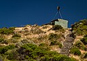
| Oliver Hill Battery (Q56053699)
|
State Registered Place
|
|
|
32°00′33″S 115°30′55″E / 32.00925732°S 115.5152615°E / -32.00925732; 115.5152615
|
526
|

|
| One Mile Jetty (Q56053704)
|
State Registered Place
|
|
|
24°52′43″S 113°37′21″E / 24.8785392°S 113.622373°E / -24.8785392; 113.622373
|
467
|

|
| One Mile Jetty and Tramway (Q56053707)
|
State Registered Place
|
|
|
24°52′48″S 113°38′28″E / 24.88005078°S 113.6410676°E / -24.88005078; 113.6410676
|
4566
|

|
| Operators Accommodation "The Barracks" Wireless Hill (Q56053710)
|
State Registered Place
|
|
|
32°01′37″S 115°49′41″E / 32.02706087°S 115.8281799°E / -32.02706087; 115.8281799
|
6063
|

|
| Ord & Bateman Street Precinct (Q56053714)
|
State Registered Place
|
|
|
32°03′11″S 115°45′20″E / 32.05299988°S 115.7554715°E / -32.05299988; 115.7554715
|
13806
|
|
| Ord River Cemetery (Q56053715)
|
State Registered Place
|
|
|
17°23′58″S 128°52′12″E / 17.39946197°S 128.8699233°E / -17.39946197; 128.8699233
|
3356
|
|
| Ord River Station Homestead (former) (Q56053716)
|
State Registered Place
|
|
|
17°23′57″S 128°52′00″E / 17.39912133°S 128.8667318°E / -17.39912133; 128.8667318
|
24393
|
|
| Ord River Station Homestead (former) & Cemetery (Q56085119)
|
State Registered Place
|
|
|
|
1174
|
|
| Orient Hotel (Q7102297)
|
State Registered Place
|
|
|
32°03′20″S 115°44′39″E / 32.055514°S 115.744043°E / -32.055514; 115.744043
|
914
|

|
| Original Pioneer Cemetery (Q66975853)
|
State Registered Place
|
Coolgardie
|
|
30°56′59″S 121°09′17″E / 30.949736°S 121.15474°E / -30.949736; 121.15474
|
558
|
|
| Original Railway Station (1878-93), Geraldton (Q66975854)
|
State Registered Place
|
Geraldton
|
|
28°46′32″S 114°36′20″E / 28.77564°S 114.605602°E / -28.77564; 114.605602
|
1068
|
|
| Original Roman Catholic Church site (Q66975856)
|
State Registered Place
|
Kalgoorlie
|
|
30°44′29″S 121°28′33″E / 30.741485°S 121.475933°E / -30.741485; 121.475933
|
1268
|
|
| Original Wellstead Home (Q66975858)
|
State Registered Place
|
Bremer Bay
|
|
34°26′06″S 119°21′47″E / 34.435045°S 119.363159°E / -34.435045; 119.363159
|
23982
|
|
| Osborne Primary School (Q66975860)
|
State Registered Place
|
Osborne Park
|
|
31°53′56″S 115°49′30″E / 31.899002°S 115.824966°E / -31.899002; 115.824966
|
8802
|
|
| Our Lady of Fatima Catholic Church & fmr Convent (Q66975863)
|
State Registered Place
|
Nanson
|
|
28°33′58″S 114°45′19″E / 28.566133°S 114.755235°E / -28.566133; 114.755235
|
473
|
|
| Our Lady of Montserrat, Southern Cross (Q56053727)
|
State Registered Place
|
|
|
31°13′48″S 119°19′27″E / 31.22992207°S 119.3241687°E / -31.22992207; 119.3241687
|
2801
|

|
| Outram Street Terraces (Q56053728)
|
State Registered Place
|
West Perth
|
|
31°56′49″S 115°50′27″E / 31.94705884°S 115.8407127°E / -31.94705884; 115.8407127
|
4506
|

|
| Overton Lodge (Q56053729)
|
State Registered Place
|
Cottesloe
|
|
31°59′39″S 115°45′17″E / 31.99426332°S 115.7545876°E / -31.99426332; 115.7545876
|
18556
|

|
| Owston's Buildings (Q29025107)
|
State Registered Place
|
|
|
32°03′21″S 115°44′35″E / 32.05573°S 115.74302°E / -32.05573; 115.74302
|
909
|

|
| P&O Building (Q16885316)
|
State Registered Place
|
|
|
32°03′18″S 115°44′34″E / 32.05503°S 115.742774°E / -32.05503; 115.742774
|
981
|

|
| P&O Building (Q17020338)
|
State Registered Place
|
|
|
31°57′14″S 115°51′25″E / 31.95387°S 115.85706°E / -31.95387; 115.85706
|
4587
|

|
| P&O Hotel (Q28225140)
|
State Registered Place
|
|
|
32°03′20″S 115°44′37″E / 32.0556548°S 115.7436252°E / -32.0556548; 115.7436252
|
911
|

|
| P.J. Morriss Building (Q56053732)
|
State Registered Place
|
Fremantle
|
|
32°03′22″S 115°44′36″E / 32.05604643°S 115.7432491°E / -32.05604643; 115.7432491
|
956
|
|
| Pa Norman's House, Broome (Q56053733)
|
State Registered Place
|
|
|
17°57′47″S 122°14′08″E / 17.96315016°S 122.2356557°E / -17.96315016; 122.2356557
|
299
|
|
| Padbury's Stores & Residence (Q56053734)
|
State Registered Place
|
|
|
31°53′48″S 115°58′26″E / 31.89676299°S 115.9739595°E / -31.89676299; 115.9739595
|
4105
|

|
| Paddy Hannan's Statue, Town Hall (Q66975865)
|
State Registered Place
|
Kalgoorlie
|
|
30°44′56″S 121°28′14″E / 30.748795°S 121.470679°E / -30.748795; 121.470679
|
1282
|

|
| Pagoda Resort and Spa (Q66975866)
|
State Registered Place
|
Como
|
|
31°59′27″S 115°51′19″E / 31.990923°S 115.855225°E / -31.990923; 115.855225
|
2403
|

|
| Paisley Centre (Q66975868)
|
State Registered Place
|
Bunbury
|
|
33°19′35″S 115°38′22″E / 33.326408°S 115.63947°E / -33.326408; 115.63947
|
330
|

|
| Pakenham Street Art Space (Q56054342)
|
State Registered Place
|
|
|
32°03′16″S 115°44′42″E / 32.05438634°S 115.7449954°E / -32.05438634; 115.7449954
|
18772
|

|
| Palace Hotel, Perth (Q7126172)
|
State Registered Place
|
Perth
|
|
31°57′17″S 115°51′25″E / 31.9546°S 115.857°E / -31.9546; 115.857
|
2114
|

|
| Palace Hotel, Southern Cross (Q66975872)
|
State Registered Place
|
Southern Cross
|
|
31°14′02″S 119°19′47″E / 31.233851°S 119.329637°E / -31.233851; 119.329637
|
2812
|

|
| Pallottine Monastery (Q66975873)
|
State Registered Place
|
Tardun
|
|
28°47′16″S 115°50′37″E / 28.787675°S 115.843657°E / -28.787675; 115.843657
|
1673
|
|
| Palm Trees (Q66975875)
|
State Registered Place
|
East Fremantle
|
|
32°02′25″S 115°46′11″E / 32.040365°S 115.769805°E / -32.040365; 115.769805
|
10323
|

|
| Park Avenue Building, University of Western Australia (Q66975877)
|
State Registered Place
|
Crawley
|
|
31°58′23″S 115°49′22″E / 31.973183°S 115.822666°E / -31.973183; 115.822666
|
3545
|

|
| Park Buildings (Q66975878)
|
State Registered Place
|
Kalgoorlie
|
|
30°44′48″S 121°28′27″E / 30.746557°S 121.474166°E / -30.746557; 121.474166
|
1299
|
|
| Parkerville Children's Home & Cemetery (Q66975880)
|
State Registered Place
|
Parkerville
|
|
31°52′20″S 116°08′13″E / 31.872219°S 116.137013°E / -31.872219; 116.137013
|
8546
|

|
| Parliament House (Q1371068)
|
State Registered Place
|
West Perth
|
|
31°57′06″S 115°50′49″E / 31.9516°S 115.847°E / -31.9516; 115.847
|
2239
|

|
| Parry Street Precinct (Q66975883)
|
State Registered Place
|
Perth
|
|
31°56′54″S 115°52′02″E / 31.948233°S 115.867285°E / -31.948233; 115.867285
|
11543
|
|
| Paterson & Co Fruit Packing Shed Complex (Q66975885)
|
State Registered Place
|
Bridgetown
|
|
33°57′20″S 116°08′13″E / 33.95554°S 116.137045°E / -33.95554; 116.137045
|
3220
|

|
| Patrick Taylor Cottage (Q24190625)
|
State Registered Place
|
|
|
35°01′37″S 117°52′52″E / 35.026999221399°S 117.88108671155932°E / -35.02699922139919; 117.88108671155932
|
19
|

|
| Patroni's Guest Home (Q71371336)
|
State Registered Place
|
Gwalia
|
|
28°54′48″S 121°19′52″E / 28.913308730121°S 121.33109339047904°E / -28.91330873012061; 121.33109339047904
|
1466
|
|
| Patroni's Guest House (514) (Q66975887)
|
State Registered Place
|
Gwalia
|
|
28°54′48″S 121°19′53″E / 28.913471°S 121.331258°E / -28.913471; 121.331258
|
24490
|

|
| Patroni's Guest House (515) (Q66975888)
|
State Registered Place
|
Gwalia
|
|
28°54′48″S 121°19′53″E / 28.91329°S 121.331258°E / -28.91329; 121.331258
|
24458
|
|
| Pavilion - Applecross Primary School (Q66975890)
|
State Registered Place
|
Applecross
|
|
32°00′39″S 115°50′23″E / 32.010957°S 115.839681°E / -32.010957; 115.839681
|
17794
|

|
| Paxwold Girl Guides Camp (Q66975892)
|
State Registered Place
|
Lesmurdie
|
|
32°01′17″S 116°02′29″E / 32.021419°S 116.041417°E / -32.021419; 116.041417
|
10411
|
|
| Peace Memorial Rose Garden (Q56761927)
|
State Registered Place
|
Nedlands
|
|
31°58′50″S 115°47′58″E / 31.98069°S 115.799456°E / -31.98069; 115.799456
|
13668
|

|
| Peace Pine Tree at District Hospital (Q66975896)
|
State Registered Place
|
Denmark
|
|
34°57′24″S 117°21′16″E / 34.95677°S 117.354522°E / -34.95677; 117.354522
|
14309
|
|
| Pearse's Buildings (Q66975898)
|
State Registered Place
|
Fremantle
|
|
32°03′17″S 115°44′43″E / 32.054644°S 115.745224°E / -32.054644; 115.745224
|
920
|

|
| Peedamulla Homestead (ruin) (Q66975899)
|
State Registered Place
|
Onslow
|
|
21°50′38″S 115°37′34″E / 21.843796°S 115.626011°E / -21.843796; 115.626011
|
4656
|
|
| Pemberton Swimming Pool (Q66975901)
|
State Registered Place
|
Pemberton
|
|
34°26′30″S 116°01′55″E / 34.441702°S 116.031854°E / -34.441702; 116.031854
|
11383
|
|
| Pemberton Timber Mill Workers' Cottages Precinct (Q66975903)
|
State Registered Place
|
Pemberton
|
|
34°26′53″S 116°02′02″E / 34.447989°S 116.033945°E / -34.447989; 116.033945
|
11381
|
|
| Pemberton Uniting Church (Q66975905)
|
State Registered Place
|
Pemberton
|
|
34°26′46″S 116°02′00″E / 34.446035°S 116.033231°E / -34.446035; 116.033231
|
1522
|
|
| Pemberton-Northcliffe Railway & Railway Station (Q56053763)
|
State Registered Place
|
|
|
34°32′15″S 116°01′31″E / 34.53752048°S 116.0251394°E / -34.53752048; 116.0251394
|
4637
|
|
| Peninsula Hotel (Q56053764)
|
State Registered Place
|
Maylands
|
|
31°55′41″S 115°53′29″E / 31.927977258276°S 115.89137538072085°E / -31.927977258275803; 115.89137538072085
|
2423
|

|
| Peninsula Hotel (fmr), Boatsheds & Stingray Point (Q56053765)
|
State Registered Place
|
|
|
32°31′46″S 115°43′01″E / 32.5294808°S 115.7168273°E / -32.5294808; 115.7168273
|
1487
|

|
| Penshurst (Q56053766)
|
State Registered Place
|
East Fremantle
|
|
32°01′59″S 115°46′20″E / 32.03307319°S 115.7721716°E / -32.03307319; 115.7721716
|
3694
|

|
| Pensioner Guard Cottage (Q56053767)
|
State Registered Place
|
Bassendean
|
|
31°54′17″S 115°57′33″E / 31.90476308°S 115.9591926°E / -31.90476308; 115.9591926
|
131
|

|
| Perry's Paddock, Cottage & Stables (Q56053768)
|
State Registered Place
|
|
|
31°47′04″S 115°48′03″E / 31.78432379°S 115.8007951°E / -31.78432379; 115.8007951
|
9484
|

|
| Perth Chest Clinic (Q56053769)
|
State Registered Place
|
|
|
31°57′18″S 115°51′53″E / 31.95508°S 115.8646736°E / -31.95508; 115.8646736
|
2050
|

|
| Perth Concert Hall (Q7170839)
|
State Registered Place
|
|
|
31°57′29″S 115°51′50″E / 31.958°S 115.86385°E / -31.958; 115.86385
|
4571
|

|
| Perth Court of Petty Sessions (Q66975907)
|
State Registered Place
|
Perth
|
|
31°57′03″S 115°51′41″E / 31.950944444444°S 115.8615°E / -31.950944444444445; 115.8615
|
1963
|

|
| Perth Dental Hospital Main Block (Q66975909)
|
State Registered Place
|
Perth
|
|
31°57′17″S 115°52′05″E / 31.954751°S 115.868066°E / -31.954751; 115.868066
|
2131
|

|
| Perth Girls' High School (Q65055104)
|
State Registered Place
|
|
|
31°57′23″S 115°52′33″E / 31.956284°S 115.875897°E / -31.956284; 115.875897
|
2173
|

|
| Perth Girls' Orphanage (Q66975910)
|
State Registered Place
|
East Perth
|
|
31°57′37″S 115°52′26″E / 31.960161°S 115.874013°E / -31.960161; 115.874013
|
2159
|

|
| Perth Government Stores (Q66975912)
|
State Registered Place
|
Perth
|
|
31°57′15″S 115°51′49″E / 31.954056°S 115.863622°E / -31.954056; 115.863622
|
2056
|

|
| Perth Hostel (Q66975914)
|
State Registered Place
|
Perth
|
|
31°56′58″S 115°51′34″E / 31.949495°S 115.859354°E / -31.949495; 115.859354
|
11588
|

|
| Perth Institute of Contemporary Arts (Q2072568)
|
State Registered Place
|
Perth
|
|
31°56′59″S 115°51′37″E / 31.949811040388°S 115.8602127930358°E / -31.94981104038783; 115.8602127930358
|
2028
|

|
| Perth Mint (Q917524)
|
State Registered Place
|
Perth
|
|
31°57′26″S 115°52′09″E / 31.957275524163°S 115.8691752669395°E / -31.957275524163393; 115.8691752669395
|
2166
|

|
| Perth Modern School (Q7170874)
|
State Registered Place
|
Subiaco
|
|
31°56′39″S 115°50′18″E / 31.94429793°S 115.8382224°E / -31.94429793; 115.8382224
|
2450
|

|
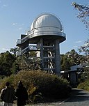
| Perth Observatory (Q525762)
|
State Registered Place
|
Bickley
|
|
32°00′28″S 116°08′09″E / 32.00781073°S 116.1357875°E / -32.00781073; 116.1357875
|
10551
|
|
| Perth Railway Precinct (Q66975916)
|
State Registered Place
|
Perth
|
|
31°57′05″S 115°51′36″E / 31.951284°S 115.859897°E / -31.951284; 115.859897
|
2133
|

|
| Perth Rectangular Stadium (Q978904)
|
State Registered Place
|
Perth
|
|
31°56′45″S 115°52′12″E / 31.945751164145°S 115.86992375454544°E / -31.945751164144937; 115.86992375454544
|
2992
|

|
| Perth Town Hall (Q7170899)
|
State Registered Place
|
|
|
31°57′18″S 115°51′38″E / 31.95491976°S 115.860478°E / -31.95491976; 115.860478
|
1953
|

|
| Perth Trades Hall (Q7170900)
|
State Registered Place
|
Perth
|
|
31°56′59″S 115°51′46″E / 31.94978°S 115.86272°E / -31.94978; 115.86272
|
8783
|

|
| Peter Pan (Q66975919)
|
State Registered Place
|
Coolgardie
|
|
30°57′00″S 121°09′50″E / 30.949941°S 121.163989°E / -30.949941; 121.163989
|
1737
|
|
| Phillimore Chambers (Q63251443)
|
State Registered Place
|
Fremantle
|
|
32°03′18″S 115°44′32″E / 32.055134°S 115.742356°E / -32.055134; 115.742356
|
979
|
|
| Phillimore Street Plane Tree (Q56053333)
|
State Registered Place
|
|
|
32°03′17″S 115°44′35″E / 32.05469899°S 115.7429273°E / -32.05469899; 115.7429273
|
21517
|

|
| Phineas Seeligson's (Q66975924)
|
State Registered Place
|
Perth
|
|
31°57′09″S 115°51′40″E / 31.952552°S 115.861°E / -31.952552; 115.861
|
1961
|

|
| Piccadilly Theatre and Arcade (Q7190567)
|
State Registered Place
|
Perth
|
|
31°57′12″S 115°51′30″E / 31.95335235°S 115.858261°E / -31.95335235; 115.858261
|
2065
|

|
| Picton Inn Hotel (Q66975928)
|
State Registered Place
|
Wollaston
|
|
33°20′57″S 115°40′35″E / 33.349161°S 115.676478°E / -33.349161; 115.676478
|
382
|
|
| Pier Hotel (Q66976200)
|
State Registered Place
|
Fremantle
|
|
32°03′24″S 115°44′35″E / 32.056682°S 115.743112°E / -32.056682; 115.743112
|
20467
|
|
| Piesse's Winery, Katanning (Q66975929)
|
State Registered Place
|
Katanning
|
|
33°40′50″S 117°33′24″E / 33.68048°S 117.556662°E / -33.68048; 117.556662
|
1334
|

|
| Pillar Box (Q66975932)
|
State Registered Place
|
Claremont
|
|
31°58′57″S 115°47′07″E / 31.982438°S 115.785306°E / -31.982438; 115.785306
|
495
|

|
| Pilots House (Cottages K1 and K2) (Q71267057)
|
State Registered Place
|
|
|
31°59′41″S 115°32′25″E / 31.994784°S 115.540406°E / -31.994784; 115.540406
|
531
|
|
| Pindar Garage Buildings (Q66975934)
|
State Registered Place
|
Pindar
|
|
28°28′39″S 115°47′19″E / 28.477362°S 115.788706°E / -28.477362; 115.788706
|
1668
|

|
| Pindar Garage Residence (Q66975935)
|
State Registered Place
|
Pindar
|
|
28°28′38″S 115°47′20″E / 28.477332°S 115.788803°E / -28.477332; 115.788803
|
25466
|

|
| Pindar Hotel (Q66975938)
|
State Registered Place
|
Pindar
|
|
28°28′37″S 115°47′26″E / 28.47683°S 115.790454°E / -28.47683; 115.790454
|
1669
|

|
| Pine Court (Q66975940)
|
State Registered Place
|
Cottesloe
|
|
31°59′43″S 115°45′24″E / 31.995389°S 115.756606°E / -31.995389; 115.756606
|
7495
|

|
| Pine Lodge (Q66975942)
|
State Registered Place
|
Cottesloe
|
|
31°59′41″S 115°45′26″E / 31.99473°S 115.757101°E / -31.99473; 115.757101
|
3682
|

|
| Pingaring CWA Rooms (Q56053791)
|
State Registered Place
|
|
|
32°45′11″S 118°37′36″E / 32.75303326°S 118.6265935°E / -32.75303326; 118.6265935
|
6912
|
|
| Pingelly Post Office (Q56053792)
|
State Registered Place
|
|
|
32°32′02″S 117°05′02″E / 32.53387°S 117.0838678°E / -32.53387; 117.0838678
|
2252
|

|
| Pinjarra Court House (former) (Q56053793)
|
State Registered Place
|
|
|
32°37′44″S 115°52′30″E / 32.62900463°S 115.8748957°E / -32.62900463; 115.8748957
|
1748
|

|
| Pinjarra Massacre Site (Q56053794)
|
State Registered Place
|
|
|
32°38′29″S 115°52′11″E / 32.64137309°S 115.8698229°E / -32.64137309; 115.8698229
|
3957
|

|
| Pinjarra Post Office (Q56053795)
|
State Registered Place
|
|
|
32°37′44″S 115°52′30″E / 32.6288696°S 115.8750525°E / -32.6288696; 115.8750525
|
1749
|

|
| Pinjarra Railway Yards (Q56053796)
|
State Registered Place
|
|
|
32°37′45″S 115°52′47″E / 32.62909772°S 115.8798243°E / -32.62909772; 115.8798243
|
3097
|
|
| Pioneer Museum, Greenough (Q56053797)
|
State Registered Place
|
Greenough
|
|
28°54′54″S 114°42′38″E / 28.91494469°S 114.7104871°E / -28.91494469; 114.7104871
|
4285
|

|
| Pioneer Park (Q28220377)
|
State Registered Place
|
|
|
32°03′11″S 115°44′44″E / 32.05307558°S 115.7454698°E / -32.05307558; 115.7454698
|
22572
|

|
| Pithara Hall & Supper Room (Q66975944)
|
State Registered Place
|
Pithara
|
|
30°23′15″S 116°40′07″E / 30.387497°S 116.668564°E / -30.387497; 116.668564
|
667
|
|
| Poinciana House (Q66975945)
|
State Registered Place
|
Marble Bar
|
|
21°10′15″S 119°44′50″E / 21.170866°S 119.747279°E / -21.170866; 119.747279
|
817
|
|
| Point Cloates Lighthouse (Q28376319)
|
State Registered Place
|
|
|
22°42′06″S 113°40′57″E / 22.701794°S 113.682379°E / -22.701794; 113.682379
|
5491
|

|
| Point King Lighthouse (Q23073792)
|
State Registered Place
|
Albany
|
|
35°02′06″S 117°55′06″E / 35.035027777778°S 117.91825°E / -35.035027777778; 117.91825
|
3212
|

|
| Point Moore Lighthouse (Q28376315)
|
State Registered Place
|
West End
|
|
28°46′58″S 114°34′46″E / 28.782769°S 114.579412°E / -28.782769; 114.579412
|
3927
|

|
| Point Peron K Battery (Q66627877)
|
State Registered Place
|
|
|
32°16′09″S 115°41′19″E / 32.269194444444°S 115.68869444444444°E / -32.269194444444445; 115.68869444444444
|
3365
|
|
| Police Lock-up (Q66975949)
|
State Registered Place
|
Southern Cross
|
|
31°13′53″S 119°19′36″E / 31.231524°S 119.326793°E / -31.231524; 119.326793
|
2806
|
|
| Police Quarters (Q66975951)
|
State Registered Place
|
Trayning
|
|
31°06′46″S 117°47′38″E / 31.112723°S 117.793812°E / -31.112723; 117.793812
|
17864
|
|
| Police Quarters and Lockup (Q64582501)
|
State Registered Place
|
|
|
20°40′42″S 117°11′20″E / 20.678461°S 117.189022°E / -20.678461; 117.189022
|
3229
|

|
| Police Station (Q66975952)
|
State Registered Place
|
Northam
|
|
31°39′27″S 116°40′09″E / 31.65744°S 116.669107°E / -31.65744; 116.669107
|
24983
|
|
| Police Station and Gaol Complex (Q66975953)
|
State Registered Place
|
Mount Barker
|
|
34°37′05″S 117°39′37″E / 34.618117°S 117.660167°E / -34.618117; 117.660167
|
2268
|

|
| Poole Street Footbridge (Q66975955)
|
State Registered Place
|
Northam
|
|
31°39′36″S 116°39′31″E / 31.659984°S 116.658577°E / -31.659984; 116.658577
|
3549
|
|
| Port Flour Mill (Q66975957)
|
State Registered Place
|
Fremantle
|
|
32°03′25″S 115°44′53″E / 32.057063°S 115.747947°E / -32.057063; 115.747947
|
871
|

|
| Port Jackson Fig, Mt Newman House (Q66975958)
|
State Registered Place
|
Perth
|
|
31°57′12″S 115°51′12″E / 31.953447°S 115.853348°E / -31.953447; 115.853348
|
4380
|

|
| Post Box, Kings Cottage (Q66975961)
|
State Registered Place
|
Bunbury
|
|
33°20′29″S 115°38′56″E / 33.341448°S 115.648986°E / -33.341448; 115.648986
|
2535
|
|
| Presbyterian Church, Meekatharra (Q66975962)
|
State Registered Place
|
Meekatharra
|
|
26°35′36″S 118°29′56″E / 26.593376°S 118.498783°E / -26.593376; 118.498783
|
1529
|
|
| Presentation Convent (Q66975963)
|
State Registered Place
|
Mullewa
|
|
28°32′20″S 115°31′02″E / 28.538895°S 115.517274°E / -28.538895; 115.517274
|
5112
|

|
| Priest House (Q66975964)
|
State Registered Place
|
Mullewa
|
|
28°32′20″S 115°31′04″E / 28.53898°S 115.51785°E / -28.53898; 115.51785
|
1657
|

|
| Priest's House (Q66975965)
|
State Registered Place
|
Greenough
|
|
28°56′36″S 114°44′37″E / 28.94347°S 114.743719°E / -28.94347; 114.743719
|
1158
|
|
| Prince of Wales Hotel (Q66975966)
|
State Registered Place
|
Bunbury
|
|
33°19′35″S 115°38′18″E / 33.326433°S 115.638453°E / -33.326433; 115.638453
|
354
|

|
| Princess May Reserve (Q21936398)
|
State Registered Place
|
Fremantle
|
|
32°03′01″S 115°44′58″E / 32.050392°S 115.749412°E / -32.050392; 115.749412
|
851
|
|
| Princess Royal Fortress (Q24185471)
|
State Registered Place
|
Mount Clarence
|
|
35°01′51″S 117°54′41″E / 35.03072222°S 117.91125°E / -35.03072222; 117.91125
|
26
|

|
| Princess Theatre (Q14935900)
|
State Registered Place
|
|
|
32°03′13″S 115°44′45″E / 32.053669°S 115.745845°E / -32.053669; 115.745845
|
953
|

|
| Prisoner of War Hut (Q56053824)
|
State Registered Place
|
|
|
31°55′29″S 118°15′13″E / 31.92466851°S 118.2535452°E / -31.92466851; 118.2535452
|
10652
|
|
| Proclamation Tree and Marmion Memorial (Q56053825)
|
State Registered Place
|
|
|
32°03′01″S 115°45′00″E / 32.0502554°S 115.7499963°E / -32.0502554; 115.7499963
|
841
|

|
| Prospect Villa (Q56053826)
|
State Registered Place
|
|
|
33°39′10″S 115°20′40″E / 33.6527335°S 115.344341°E / -33.6527335; 115.344341
|
389
|

|
| Protestant Hall (former), Perth (Q56053827)
|
State Registered Place
|
|
|
31°56′53″S 115°51′51″E / 31.94796734°S 115.8641328°E / -31.94796734; 115.8641328
|
1969
|

|
| Public Buildings, East Fremantle (Q56053828)
|
State Registered Place
|
East Fremantle
|
|
32°02′29″S 115°45′46″E / 32.04148707°S 115.762771°E / -32.04148707; 115.762771
|
789
|
|
| Pyrmont (Q23073959)
|
State Registered Place
|
|
|
35°01′18″S 117°52′55″E / 35.0216268°S 117.8820093°E / -35.0216268; 117.8820093
|
44
|

|
| Quaalup Homestead Group, near Bremer Bay (Q56053830)
|
State Registered Place
|
Bremer Bay
|
|
34°15′36″S 119°24′37″E / 34.2598806°S 119.4102736°E / -34.2598806; 119.4102736
|
1249
|

|
| Quairading State School (Q66975968)
|
State Registered Place
|
Quairading
|
|
32°00′26″S 117°24′00″E / 32.007157°S 117.400042°E / -32.007157; 117.400042
|
17589
|
|
| Quairading State School & Quarters (Q66975969)
|
State Registered Place
|
Quairading
|
|
32°00′26″S 117°24′00″E / 32.007159°S 117.400042°E / -32.007159; 117.400042
|
4914
|
|
| Quarantine Station, Woodman Point (Q66975970)
|
State Registered Place
|
Coogee
|
|
32°07′57″S 115°45′20″E / 32.132531°S 115.755538°E / -32.132531; 115.755538
|
499
|

|
| Quaranup (Q24185485)
|
State Registered Place
|
Albany
|
|
35°03′09″S 117°54′49″E / 35.05241667°S 117.9135°E / -35.05241667; 117.9135
|
84
|

|
| Quarry Amphitheatre (Q7269203)
|
State Registered Place
|
City Beach
|
|
31°56′22″S 115°46′39″E / 31.9395°S 115.7775°E / -31.9395; 115.7775
|
9102
|

|
| Quartermaine's Building (Q66498690)
|
State Registered Place
|
|
|
32°03′17″S 115°44′37″E / 32.054733°S 115.743716°E / -32.054733; 115.743716
|
880
|

|
| Queen's Methodist Church, Boulder (Q66975973)
|
State Registered Place
|
Boulder
|
|
30°47′00″S 121°29′24″E / 30.783461°S 121.489951°E / -30.783461; 121.489951
|
210
|
|
| Queens Buildings (Q66975974)
|
State Registered Place
|
Perth
|
|
31°57′09″S 115°51′25″E / 31.952523°S 115.857028°E / -31.952523; 115.857028
|
2058
|

|
| Queens Gardens (Q7270764)
|
State Registered Place
|
East Perth
|
|
31°57′34″S 115°52′37″E / 31.9595°S 115.877°E / -31.9595; 115.877
|
4572
|

|
| Quindanning Hotel (Q66975975)
|
State Registered Place
|
Quindanning
|
|
33°02′38″S 116°34′06″E / 33.043828°S 116.568288°E / -33.043828; 116.568288
|
16215
|

|
| R.S.L. Building / RSL Headquarters (Q66975977)
|
State Registered Place
|
Esperance
|
|
33°51′36″S 121°53′34″E / 33.860116°S 121.892916°E / -33.860116; 121.892916
|
825
|

|
| RAAF Headquarters Bunker, Belmont (Q66975978)
|
State Registered Place
|
Belmont
|
|
31°56′30″S 115°56′15″E / 31.941713°S 115.937409°E / -31.941713; 115.937409
|
16785
|
|
| Radio Theatre Building (Q66975979)
|
State Registered Place
|
Geraldton
|
|
28°46′32″S 114°36′25″E / 28.775439°S 114.607°E / -28.775439; 114.607
|
1060
|
|
| Raffles Hotel (Q7282579)
|
State Registered Place
|
Applecross
|
|
32°00′39″S 115°51′06″E / 32.010829650438°S 115.85169342609016°E / -32.01082965043828; 115.85169342609016
|
1544
|

|
| Railway Cottage, Bluff Point & Two Mile Well (Q66975980)
|
State Registered Place
|
Beresford
|
|
28°44′53″S 114°37′12″E / 28.747967°S 114.619896°E / -28.747967; 114.619896
|
13253
|
|
| Railway Cottages, Waroona (Q66975981)
|
State Registered Place
|
Waroona
|
|
32°51′15″S 115°55′15″E / 32.854152°S 115.920789°E / -32.854152; 115.920789
|
15927
|

|
| Railway Dam, Merredin (Q66975982)
|
State Registered Place
|
Merredin
|
|
31°28′13″S 118°17′34″E / 31.470293°S 118.292756°E / -31.470293; 118.292756
|
13523
|
|
| Railway Goods Shed (Q56085284)
|
State Registered Place
|
|
|
32°56′10″S 117°10′48″E / 32.936103833147°S 117.17994496601594°E / -32.9361038331466; 117.17994496601594
|
4779
|
|
| Railway Goods Shed (Q56085285)
|
State Registered Place
|
Mullewa
|
|
28°32′33″S 115°30′40″E / 28.542498912134°S 115.5111976871628°E / -28.542498912134317; 115.5111976871628
|
25458
|

|
| Railway Goods Shed (Q66975983)
|
State Registered Place
|
Yalgoo
|
|
28°20′50″S 116°40′58″E / 28.347151°S 116.682755°E / -28.347151; 116.682755
|
4181
|
|
| Railway Goods Shed & Footbridge, Collie (Q66975985)
|
State Registered Place
|
Collie
|
|
33°21′35″S 116°09′17″E / 33.359756°S 116.15467°E / -33.359756; 116.15467
|
540
|

|
| Railway Hotel (Q66975986)
|
State Registered Place
|
North Fremantle
|
|
32°02′13″S 115°45′05″E / 32.037042°S 115.751347°E / -32.037042; 115.751347
|
2927
|

|
| Railway Hotel, Coolgardie (Q66975990)
|
State Registered Place
|
Coolgardie
|
|
30°57′18″S 121°09′47″E / 30.955077°S 121.162942°E / -30.955077; 121.162942
|
570
|
|
| Railway Hotel, Perth (Q17054301)
|
State Registered Place
|
Perth
|
|
31°57′10″S 115°51′41″E / 31.9528°S 115.8613°E / -31.9528; 115.8613
|
1959
|

|
| Railway House (fmr) (Q56053861)
|
State Registered Place
|
|
|
30°57′20″S 121°09′44″E / 30.95555854°S 121.1622579°E / -30.95555854; 121.1622579
|
7372
|
|
| Railway House (former), Utakarra (Q56053862)
|
State Registered Place
|
Utakarra
|
|
28°46′38″S 114°38′52″E / 28.77730918°S 114.647913°E / -28.77730918; 114.647913
|
13373
|
|
| Railway House, 2 Hale Street, Narrogin (Q56053857)
|
State Registered Place
|
|
|
32°56′12″S 117°10′57″E / 32.9366026°S 117.1825191°E / -32.9366026; 117.1825191
|
24855
|
|
| Railway House, 6 Hale Street, Narrogin (Q56053863)
|
State Registered Place
|
|
|
32°56′14″S 117°10′57″E / 32.93731429°S 117.1824949°E / -32.93731429; 117.1824949
|
14860
|
|
| Railway Houses, 2-4 Hale Street, Narrogin (Q56053864)
|
State Registered Place
|
|
|
32°56′13″S 117°10′57″E / 32.93690179°S 117.1825089°E / -32.93690179; 117.1825089
|
1824
|
|
| Railway Houses, Ganzer Street (Q56053865)
|
State Registered Place
|
|
|
30°53′26″S 116°43′00″E / 30.89045547°S 116.7167287°E / -30.89045547; 116.7167287
|
12462
|
|
| Railway Housing Precinct, Merredin (Q56053866)
|
State Registered Place
|
|
|
31°29′02″S 118°16′27″E / 31.48387628°S 118.2742033°E / -31.48387628; 118.2742033
|
15750
|
|
| Railway Institute, Kalgoorlie (Q66975991)
|
State Registered Place
|
Kalgoorlie
|
|
30°44′52″S 121°28′00″E / 30.747822°S 121.466593°E / -30.747822; 121.466593
|
1278
|
|
| Railway Institute, Northam (Q66975993)
|
State Registered Place
|
Northam
|
|
31°39′38″S 116°39′54″E / 31.660693°S 116.665076°E / -31.660693; 116.665076
|
1898
|
|
| Railway Rock Catchment Dam Group, Yilgarn (Q66975995)
|
State Registered Place
|
Bodallin
|
|
31°17′14″S 119°38′21″E / 31.287162°S 119.639137°E / -31.287162; 119.639137
|
25378
|
|
| Railway Water Tank & Column (Q66975997)
|
State Registered Place
|
Mullewa
|
|
28°32′39″S 115°30′44″E / 28.544191°S 115.512124°E / -28.544191; 115.512124
|
25459
|

|
| Railway Water Tank, Corrigin (Q66975998)
|
State Registered Place
|
Corrigin
|
|
32°19′50″S 117°52′19″E / 32.330499°S 117.871933°E / -32.330499; 117.871933
|
8190
|
|
| Railway Water Tower, Broad Arrow (Q66976000)
|
State Registered Place
|
Broad Arrow
|
|
30°26′56″S 121°19′44″E / 30.448856°S 121.328904°E / -30.448856; 121.328904
|
15828
|
|
| Railway Water Tower, Cunderdin (Q66976002)
|
State Registered Place
|
Cunderdin
|
|
31°39′06″S 117°14′29″E / 31.6516°S 117.241458°E / -31.6516; 117.241458
|
647
|

|
| Railway Worker's Cottage (Q66976003)
|
State Registered Place
|
Kalgoorlie
|
|
30°44′51″S 121°27′56″E / 30.747625°S 121.465426°E / -30.747625; 121.465426
|
3792
|
|
| Railways Institute Building (Q66976005)
|
State Registered Place
|
Perth
|
|
31°57′02″S 115°51′18″E / 31.950478°S 115.855046°E / -31.950478; 115.855046
|
2146
|

|
| Raine Square (Q43067610)
|
State Registered Place
|
|
|
31°57′04″S 115°51′26″E / 31.95123494491°S 115.8573494407045°E / -31.95123494490973; 115.8573494407045
|
9824
|

|
| Randwick Stables (Q66976006)
|
State Registered Place
|
Hamilton Hill
|
|
32°04′46″S 115°45′56″E / 32.079528°S 115.765461°E / -32.079528; 115.765461
|
9242
|

|
| Rawlinna Townsite (Q66976008)
|
State Registered Place
|
Rawlinna
|
|
31°00′32″S 125°19′51″E / 31.008931°S 125.330729°E / -31.008931; 125.330729
|
15722
|

|
| Rechabite Hall (Q66976009)
|
State Registered Place
|
Perth
|
|
31°56′55″S 115°51′36″E / 31.948658°S 115.859864°E / -31.948658; 115.859864
|
2155
|

|
| Reckitt & Colman Building Facade (Q16999174)
|
State Registered Place
|
|
|
32°03′22″S 115°44′33″E / 32.0560924°S 115.7425209°E / -32.0560924; 115.7425209
|
855
|

|
| Red Mill Store (Q66976010)
|
State Registered Place
|
Bunbury
|
|
33°19′39″S 115°38′38″E / 33.327424°S 115.643969°E / -33.327424; 115.643969
|
5710
|

|
| Redemptorist Monastery, North Perth (Q7305781)
|
State Registered Place
|
North Perth
|
|
31°56′09″S 115°51′18″E / 31.9358°S 115.855°E / -31.9358; 115.855
|
2218
|

|
| Regal Theatre (Q7307927)
|
State Registered Place
|
Subiaco
|
|
31°56′48″S 115°49′26″E / 31.946782°S 115.823755°E / -31.946782; 115.823755
|
2454
|

|
| Regent Theatre (Q45919614)
|
State Registered Place
|
|
|
31°53′58″S 115°58′12″E / 31.8993846°S 115.9700364°E / -31.8993846; 115.9700364
|
14816
|

|
| Reidy House (Q56053888)
|
State Registered Place
|
|
|
33°41′26″S 117°33′03″E / 33.69050538°S 117.5507498°E / -33.69050538; 117.5507498
|
1332
|

|
| Reserve (Q56053891)
|
State Registered Place
|
Guildford
|
|
31°54′03″S 115°58′13″E / 31.90083964°S 115.9702372°E / -31.90083964; 115.9702372
|
14783
|
|
| Residence & Shop, Northbridge (Q56053895)
|
State Registered Place
|
Northbridge
|
|
31°56′39″S 115°51′15″E / 31.94410352°S 115.8541554°E / -31.94410352; 115.8541554
|
14066
|

|
| Residence (former Independent Chapel) (Q56053896)
|
State Registered Place
|
|
|
31°53′51″S 115°58′40″E / 31.89751931°S 115.9776489°E / -31.89751931; 115.9776489
|
3275
|
|
| Residence of John Curtin (Q7315409)
|
State Registered Place
|
Cottesloe
|
|
31°59′55″S 115°45′32″E / 31.9987°S 115.759°E / -31.9987; 115.759
|
7935
|

|
| Residence, 206 Grey Street, Albany (Q56053897)
|
State Registered Place
|
|
|
35°01′30″S 117°52′31″E / 35.02499569°S 117.875143°E / -35.02499569; 117.875143
|
15495
|
|
| Residence, 445 Walsh Street, Menzies (Q56053892)
|
State Registered Place
|
|
|
29°41′53″S 121°01′51″E / 29.69805742°S 121.0307389°E / -29.69805742; 121.0307389
|
23962
|
|
| Residence, 446 Walsh Street, Menzies (Q66976017)
|
State Registered Place
|
Menzies
|
|
29°41′54″S 121°01′51″E / 29.698238°S 121.030741°E / -29.698238; 121.030741
|
23968
|
|
| Residence, 447 Walsh Street, Menzies (Q66976014)
|
State Registered Place
|
Menzies
|
|
29°41′54″S 121°01′51″E / 29.698418°S 121.030744°E / -29.698418; 121.030744
|
23888
|
|
| Residence, 52 Mount Street (Q56053898)
|
State Registered Place
|
West Perth
|
|
31°57′15″S 115°50′48″E / 31.95417539°S 115.8467256°E / -31.95417539; 115.8467256
|
4342
|

|
| Residency Museum (Q24190771)
|
State Registered Place
|
|
|
35°01′43″S 117°52′51″E / 35.028642°S 117.880828°E / -35.028642; 117.880828
|
39
|

|
| Residency Museum (Q56085282)
|
State Registered Place
|
|
|
31°53′34″S 116°46′31″E / 31.8928°S 116.7754°E / -31.8928; 116.7754
|
2870
|

|
| Rifle House (Q66976019)
|
State Registered Place
|
Fremantle
|
|
32°02′38″S 115°45′21″E / 32.043826°S 115.755803°E / -32.043826; 115.755803
|
23062
|

|
| Riverbank Detention Centre, Caversham (Q66976020)
|
State Registered Place
|
Caversham
|
|
31°53′00″S 115°59′21″E / 31.88337°S 115.989071°E / -31.88337; 115.989071
|
18404
|
|
| Road Board Office, Nanson (Q66976023)
|
State Registered Place
|
Nanson
|
|
28°33′40″S 114°45′32″E / 28.561185°S 114.758956°E / -28.561185; 114.758956
|
474
|
|
| Roads Board Hall and Gardens (Q45919000)
|
State Registered Place
|
|
|
31°39′03″S 117°14′25″E / 31.6509378°S 117.2401607°E / -31.6509378; 117.2401607
|
654
|

|
| Robb Jetty Chimney (Q84998538)
|
State Registered Place
|
North Coogee
|
|
32°05′18″S 115°45′35″E / 32.088351°S 115.759635°E / -32.088351; 115.759635
|
3211
|

|
| Robert Harper Building (Q30622529)
|
State Registered Place
|
Fremantle
|
|
32°03′13″S 115°44′39″E / 32.05355556°S 115.74416667°E / -32.05355556; 115.74416667
|
984
|

|
| Robertson Park and Archaeological Sites (Q66976025)
|
State Registered Place
|
Perth
|
|
31°56′27″S 115°51′26″E / 31.940902°S 115.857185°E / -31.940902; 115.857185
|
8705
|

|
| Roe Street Cottage (Q66976027)
|
State Registered Place
|
Perth
|
|
31°56′58″S 115°51′42″E / 31.949342°S 115.861636°E / -31.949342; 115.861636
|
5111
|
|
| Roebourne Courthouse (Q66976029)
|
State Registered Place
|
Roebourne
|
|
20°46′42″S 117°08′38″E / 20.778249°S 117.143958°E / -20.778249; 117.143958
|
25072
|
|
| Roebourne Gaol (Q66976030)
|
State Registered Place
|
Roebourne
|
|
20°46′43″S 117°08′39″E / 20.778616°S 117.144131°E / -20.778616; 117.144131
|
25074
|

|
| Roebourne Hospital Group (Q66976032)
|
State Registered Place
|
Roebourne
|
|
20°46′35″S 117°08′39″E / 20.776362°S 117.144042°E / -20.776362; 117.144042
|
2339
|
|
| Roebourne Police Station (1896) (Q66976034)
|
State Registered Place
|
Roebourne
|
|
20°46′40″S 117°08′43″E / 20.777741°S 117.145248°E / -20.777741; 117.145248
|
25073
|
|
| Roebourne Police Station, Gaol & Court House Precinct (Q66976036)
|
State Registered Place
|
Roebourne
|
|
20°46′42″S 117°08′40″E / 20.778314°S 117.144415°E / -20.778314; 117.144415
|
2319
|
|
| Roebourne Post Office (Q66976037)
|
State Registered Place
|
Roebourne
|
|
20°46′35″S 117°08′43″E / 20.776475°S 117.145384°E / -20.776475; 117.145384
|
2334
|
|
| Roebourne Primary School & Quarters (Q66976039)
|
State Registered Place
|
Roebourne
|
|
20°46′34″S 117°08′35″E / 20.776186°S 117.142988°E / -20.776186; 117.142988
|
2341
|
|
| Roebuck Bay Hotel (Q66976041)
|
State Registered Place
|
Broome
|
|
17°57′18″S 122°14′39″E / 17.954864°S 122.244247°E / -17.954864; 122.244247
|
295
|

|
| Romany Restaurant (Q66976042)
|
State Registered Place
|
Perth
|
|
31°56′59″S 115°51′33″E / 31.949643°S 115.85926°E / -31.949643; 115.85926
|
12118
|

|
| Rose & Crown Cellars (Q56053918)
|
State Registered Place
|
|
|
31°53′52″S 115°58′24″E / 31.89783251°S 115.9733382°E / -31.89783251; 115.9733382
|
23571
|
|
| Rose Hotel (Q56053921)
|
State Registered Place
|
|
|
33°19′28″S 115°38′15″E / 33.32453753°S 115.637367°E / -33.32453753; 115.637367
|
376
|

|
| Rose Hotel Bottle Shop & Sample Room (Q56053922)
|
State Registered Place
|
Bunbury
|
|
33°19′29″S 115°38′17″E / 33.32468982°S 115.6379868°E / -33.32468982; 115.6379868
|
5739
|

|
| Rose and Crown Hotel (Q56053919)
|
State Registered Place
|
|
|
31°53′53″S 115°58′25″E / 31.89809308°S 115.9734828°E / -31.89809308; 115.9734828
|
2481
|

|
| Rosella House (Q56053924)
|
State Registered Place
|
Geraldton
|
|
28°46′06″S 114°37′01″E / 28.7682507°S 114.6169272°E / -28.7682507; 114.6169272
|
3458
|
|
| Rosen Buildings (Q56053925)
|
State Registered Place
|
Perth
|
|
31°56′56″S 115°51′35″E / 31.94878506°S 115.8597836°E / -31.94878506; 115.8597836
|
16437
|

|
| Rosewood House (Q56053926)
|
State Registered Place
|
|
|
30°46′49″S 121°29′07″E / 30.78028687°S 121.4853259°E / -30.78028687; 121.4853259
|
190
|
|
| Rottnest Hotel (Q66817695)
|
State Registered Place
|
|
|
31°59′54″S 115°32′32″E / 31.998328°S 115.542236°E / -31.998328; 115.542236
|
522
|

|
| Rottnest Island Museum building (Q56052931)
|
State Registered Place
|
|
|
31°59′46″S 115°32′25″E / 31.99599348°S 115.5401426°E / -31.99599348; 115.5401426
|
524
|

|


.png)


,_Perth_Central_Fire_Station_--_2019_--_0277.jpg)


_Shearing_Quarters,_Arthur_River,_April_2021_06.jpg)
_Shearing_Shed,_Arthur_River,_April_2021_03.jpg)

.JPG)
,_Barrett_Street,_June_2023_01.jpg)


.jpg)


.jpg)


.jpg)


.JPG)


.jpg)


.jpg)

.jpg)


.jpg)


.jpg)


.JPG)

.JPG)

.jpg)


.jpg)


