Commons:Wiki4Alps/See-Gaster
Jump to navigation
Jump to search
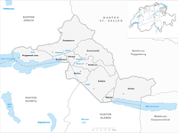
Map of See-Gaster

<< Wiki4Alps << St. Gallen
List of the cultural heritage of the district of See-Gaster in the Canton St. Gallen
[edit]
List of Monuments in the district of See-Gaster in the Canton St. Gallen.
Update: 15 April 2014
List
[edit]| KGS-Nr | Upload | Foto | Object | Other | Cov. | Cat. | Type | Address | Town | Coordinates | |||
|---|---|---|---|---|---|---|---|---|---|---|---|---|---|
| 9649 | 
|
Burg Strahlegg (römischer Wachtturm, Burgruine) | A | F | Betlis | Amden |
| ||||||
| 8082 | 
|
Gmür-Haus in Vorderächern (1822) | B | G | Rütistrasse 12 | Amden |
| ||||||
| 8083 | 
|
Katholische Kirche St. Gallus (Turm 13. Jh., Schiff 19. Jh.) | B | G | Kirchstrasse 10 | Amden |
| ||||||
| 10481 | Fründsberg (Burgstelle) | A | F | Fründsberg, Goldingen | Eschenbach |
| |||||||
| 8120 | Kusterhaus (Landrichterhaus) | A | G | Dorfstrasse 13 | Eschenbach |
| |||||||
| 8121 | Balmenrain, eisenzeitliche Höhensiedlung | B | F | Eschenbach |
| ||||||||
| 8122 | Chastel, eisenzeitliche Höhensiedlung | B | F | Bürgstrasse | Eschenbach |
| |||||||
| 8124 | 
|
Gedeckte Holzbrücke (1830) über das Aabachtobel | B | G | Neuhaus | Eschenbach |
| ||||||
| 8357 | Katholische Kirche St. Laurentius und Gallus (1755, Grubenmann) mit Beinhauskapelle | B | G | Kirchweg 588, St. Gallenkappel | Eschenbach |
| |||||||
| 8143 | _120.JPG)
|
Katholische Kirche St. Nikolaus (1681, 1784) | B | G | Dorfstrasse, Goldingen | Eschenbach |
| ||||||
| 8123 | _075.JPG)
|
Katholische Kirche St. Vinzenz (1723/26 und 1753/54) | B | G | Obergasse-Kirchweg | Eschenbach |
| ||||||
| 14073 | Pfarrhaus (1759) | B | G | Rickenstrasse 37, St. Gallenkappel | Eschenbach |
| |||||||
| 8144 | 
|
Berg Sion, Prämonstratenserinnenkloster (1772, Ende 19. Jh.) | B | G | Berg-Sion-Strasse | Gommiswald |
| ||||||
| 8145 | _219.JPG)
|
Katholische Kirche St. Jakobus der Ältere (1789) | B | G | Dorfplatz 12, Gommiswald | Gommiswald |
| ||||||
| 8257 | _242.JPG)
|
Katholische Kirche St. Magnus (1912) | B | G | Dorf, Rieden | Gommiswald |
| ||||||
| 8169 | Burgstelle Bibiton (um 1300) | B | F | Ried | Kaltbrunn |
| |||||||
| 8171 | Ehemaliger Kirchenbezirk St. Georg mit ehemaliger Beinhauskapelle | B | F/G | Hof Oberkirch | Kaltbrunn |
| |||||||
| 8170 | _312.JPG)
|
Katholische Kirche St. Georg (1821) | B | G | Dorfstrasse | Kaltbrunn |
| ||||||
| 8277 | 
|
Biberlikopf (römischer Wachtturm) | A | F | Schänis |
| |||||||
| 8282 | 
|
Ehemaliges Damenstift zum Heiligen Kreuz (Kloster Schänis) | A | G | Rathausplatz 1 | Schänis |
| ||||||
| 8278 | 
|
Gallusturm | A | G | Gallusgasse | Schänis |
| ||||||
| 8280 | 
|
Burgruine Niederwindegg | B | F | Schänis |
| |||||||
| 8281 | Gasterholz, eisenzeitliche Höhensiedlung | B | F | Schänis |
| ||||||||
| 14057 | 
|
Kapelle St. Sebastian in den Eichen | B | G | Witöfelistrasse | Schänis |
| ||||||
| 14058 | 
|
Katholische Kirche St. Johannes Nepomuk | B | G | Baumgarten, Maseltrangen | Schänis |
| ||||||
| 8283 | Letzi | B | G | Letz | Schänis |
| |||||||
| 9656 | Altweesen (spätrömisches Kastell/ mittelalterliche Wüstung) | A | F | Bahnhofstrasse / Ziegelbrückstrasse | Weesen |
| |||||||
| 8408 | Dominikanerinnenkloster Maria Zuflucht (Ende 17. Jh.) mit Klosterarchiv | B | G/S | Im Städtli 29 | Weesen |
| |||||||
| 8409 | 
|
Katholische Bühlkirche Heilig Kreuz (Ortsgemeindearchiv), mit Kaplanei | B | G | Büelstrasse | Weesen |
| ||||||
| 14096 | .jpg)
|
Reformierte Bühlkirche (Zwinglikirche) | B | G | Büelstrasse | Weesen |
| ||||||
| 14095 | Villa Kurfürst | B | G | Hauptstrasse 10 | Weesen |
|