Commons:Wiki4Alps/Monthey
Jump to navigation
Jump to search
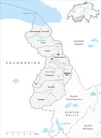
Map of Monthey

List of the cultural heritage of the district of Monthey in the Canton Valais
[edit]
List of Monuments in the district of Monthey in the Canton Valais.
Update: 15 April 2014
List
[edit]| KGS-Nr | Upload | Foto | Object | Other | Cov. | Cat. | Type | Address | Town | Coordinates | |||
|---|---|---|---|---|---|---|---|---|---|---|---|---|---|
| 6687 | Clocher (1725) de l'église Saint-Théodule avec maison dite la cure | B | G | Rue du Village 51 | Champéry |
| |||||||
| 6695 | Château d’Arbignon (monastère) | B | G | Chemin du Monastère | Collombey-Muraz |
| |||||||
| 6696 | Maison de commune | B | G | Rue des Dents-du-Midi 44 | Collombey-Muraz |
| |||||||
| 6698 | Église Saint-André, vieux clocher (1657), villa romaine et cure (1768) | B | F/G | Rue du Chablais | Collombey-Muraz |
| |||||||
| 6694 | La Barmaz und Châble-Croix, site préhistoriques | B | F | Collombey-Muraz |
| ||||||||
| 6697 | Manoir de Lavallaz (Châtillon-Larringes) | B | G | Rue des Dents-du-Midi 28–30 | Collombey-Muraz |
| |||||||
| 6857 | 
|
Château-Vieux (site archéologique) | B | F | Rue Reconfière | Monthey |
| ||||||
| 6854 | 
|
Ancien dépôt de sel puis arsenal | B | G | Rue du Bourg-aux-Favres 26 | Monthey |
| ||||||
| 6864 | 
|
Pont couvert sur la Vièze (1809) | B | G | Route de la Cretta | Monthey |
| ||||||
| 6856 | Châteu avec musée et archives du Vieux-Monthey | B | G | Rue du Château 7 | Monthey |
| |||||||
| 6855 | 
|
Chapelle Notre-Dame du Pont | B | G | Place de l’Hôtel de Ville | Monthey |
| ||||||
| 6861 | 
|
Église Notre-Dame de l’Immaculée Conception (1851) | B | G | Rue de l’Église | Monthey |
| ||||||
| 6858 | Église de Saint-Sylvestre et cure | B | G | Route de l’Église, Choëx | Monthey |
| |||||||
| 6863 | Maison Delacoste | B | G | Place de Tübingen 2 | Monthey |
| |||||||
| 6862 | 
|
Maison Dufey (de Kalbermatten) | B | G | Avenue du Crochetan 12 | Monthey |
| ||||||
| 6859 | Site romain de Marendeux | B | F | Route de Marendeux | Monthey |
| |||||||
| 10701 | Musée du Vieux-Monthey | B | S | Rue du Château 7 | Monthey |
| |||||||
| 6860 | 
|
Cure (1807) | B | G | Rue de l’Église 3 | Monthey |
| ||||||
| 6932 | Site archéologique du promontoire | B | G | La Colline | Port-Valais |
| |||||||
| 6930 | 
|
Le Bouveret, Gare et débarcadère | B | G | Chemin du Vieux-Port | Port-Valais |
| ||||||
| 6929 | Le Bouveret, bibliothèque des Bénédictins du Foyer Saint-Benoît | B | S | Route de l’Église 38 | Port-Valais |
| |||||||
| 6931 | Le Bouveret, Hôtel de la Tour (ancien dépôt de sel) | B | G | Rue du Lac | Port-Valais |
| |||||||
| 7096 | Ancien Hôtel de la Croix-Blanche (Gendarmerie) | B | G | Route de la Croix-Blanche 2 | Saint-Gingolph |
| |||||||
| 7097 | 
|
Chapelle de la Sainte Famille | B | G | Rue de la Chapelle | Saint-Gingolph |
| ||||||
| 7099 | Dépendance du château, soit maison de Rivaz-de-Nucé | B | G | Place de la Croix-Blanche | Saint-Gingolph |
| |||||||
| 10703 | 
|
Musée des Traditions et des Barques du Léman | B | S | Place de la Croix-Blanche | Saint-Gingolph |
| ||||||
| 7098 | Château (maison de commune) | B | G | Place de la Croix-Blanche | Saint-Gingolph |
| |||||||
| 7140 | Pont sur le Fayot | B | G | Troistorrents |
| ||||||||
| 7138 | Chemex, chapelle des Rois-Mages (autel) | B | K | Chemin des Ecoliers | Troistorrents |
| |||||||
| 7139 | Église de Sainte-Marie-Madeleine (autels) | B | K | Place du Village | Troistorrents |
| |||||||
| 7142 | Moulins de la Tine | B | G | La Tine | Troistorrents |
| |||||||
| 7141 | Propéra, grenier et four à pain | B | G | Chemin du Batieux 6 | Troistorrents |
| |||||||
| 10368 | 
|
Maison d'habitation, Plat | A | G | Route de Play | Val-d'Illiez |
| ||||||
| 7159 | Église Saint-Maurice et clocher | B | G | Route de la Vallée 11 | Val-d'Illiez |
| |||||||
| 7158 | Cure (1711, ancien prieuré) | B | G | Place de la Cure 1 | Val-d'Illiez |
| |||||||
| 7179 | Ancien clocher | B | G | Chemin des Deux-Clochers | Vionnaz |
| |||||||
| 7180 | Digues avec inscription et armoiries | B | G | Route de Torgon | Vionnaz |
| |||||||
| 7181 | Maison forte Barberini | B | G | Rue du Château 16 | Vionnaz |
| |||||||
| 7213 | 
|
Château de la Porte-du-Scex | B | G | Avenue de Savoie | Vouvry |
| ||||||
| 7215 | Hôtel de Ville | B | G | Grand-Rue | Vouvry |
| |||||||
| 7214 | Église Saint-Hippolyte et clocher | B | G | Avenue de l’Église | Vouvry |
| |||||||
| 7216 | Maison de la Tour | B | G | Grand-Rue | Vouvry |
|