Commons:Wiki4Alps/Entremont
Jump to navigation
Jump to search
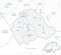
Map of Entremont

List of the cultural heritage of the district of Entremont in the Canton Valais
[edit]
List of Monuments in the district of Entremont in the Canton Valais.
Update: 15 April 2014
List
[edit]| KGS-Nr | Upload | Foto | Object | Other | Cov. | Cat. | Type | Address | Town | Coordinates | |||
|---|---|---|---|---|---|---|---|---|---|---|---|---|---|
| 6604 | Alpage de Louvie | A | G | Mauvoisin | Bagnes |
| |||||||
| 6603 | 
|
Église St-Maurice, ossuaire, ancienne cure | A | G | Chemin de l’Église, Le Châble | Bagnes |
| ||||||
| 13908 | Alpage de la Lia | B | G | Mauvoisin | Bagnes |
| |||||||
| 13909 | Alpage de Vasevay | B | G | Mauvoisin | Bagnes |
| |||||||
| 13910 | Alpage du Crêt | B | G | Mauvoisin | Bagnes |
| |||||||
| 13911 | Alpage du Giétro | B | G | Mauvoisin | Bagnes |
| |||||||
| 6613 | Ancien pont | B | G | Mauvoisin | Bagnes |
| |||||||
| 6608 | .jpg)
|
Le Cotterg - Fontaine du village | B | K | Chemin du Four, Le Châble | Bagnes |
| ||||||
| 8744 | Musée des glaciers à Lourtier | B | S | Chemin Jean-Pierre Perraudin 9, Lourtier | Bagnes |
| |||||||
| 10691 | Musée de la pierre ollaire à Champsec | B | S | Chemin des Fontaines 8, Champsec | Bagnes |
| |||||||
| 10692 | Scie et moulin de Sarreyer | B | S | Chemin du Moulin 1, Sarreyer | Bagnes |
| |||||||
| 10693 | Forge Oreiller | B | G | Chemin des Condémines 1, Le Châble | Bagnes |
| |||||||
| 6648 | 
|
Église Saint-Pierre avec tour romane | A | G | Rue de l’Église | Bourg-Saint-Pierre |
| ||||||
| 6649 | 
|
Hospice du Grand Saint-Bernard avec ses dépendances | A | G | Grand Saint-Bernard | Bourg-Saint-Pierre |
| ||||||
| 8828 | Hospice du Grand Saint-Bernard, Archives | A | S | Grand Saint-Bernard | Bourg-Saint-Pierre |
| |||||||
| 9315 | Hospice du Grand Saint-Bernard, Bibliothèque | A | S | Grand Saint-Bernard | Bourg-Saint-Pierre |
| |||||||
| 8719 | Hospice du Grand Saint-Bernard, Musée | A | S | Grand Saint-Bernard | Bourg-Saint-Pierre |
| |||||||
| 6652 | Ancien prieuré | B | G | Rue du Bourg 54 | Bourg-Saint-Pierre |
| |||||||
| 6651 | Ancien hôpital | B | G | Rue de l’Hôpital 6 | Bourg-Saint-Pierre |
| |||||||
| 6654 | Chapelle Notre-Dame de Lorette | B | G | Croix-Dessous | Bourg-Saint-Pierre |
| |||||||
| 6655 | Le 2 Maisons dites de Challant | B | G | Rue de la Laiterie | Bourg-Saint-Pierre |
| |||||||
| 6656 | Moulin sur le torrent de Valsorey | B | G | Prêt du Pont | Bourg-Saint-Pierre |
| |||||||
| 6825 | .jpg)
|
Les Moulins | A | G | Route de Fornex | Liddes |
| ||||||
| 6827 | Chapelle Saint-Étienne | B | G | Chemin de Loutze | Liddes |
| |||||||
| 6828 | Maison Bastian | B | G | Rue du Fond de Ville 30 | Liddes |
| |||||||
| 10447 | 
|
Jardin botanique alpin Flore-Alpe | A | G | Champex | Orsières |
| ||||||
| 6920 | Archives bourgeoisiales et communales | B | S | Rue de la Commune 3 | Orsières |
| |||||||
| 10577 | Hôtel du Grand-Combin | B | G | Rue du Lac 2, Champex | Orsières |
| |||||||
| 6926 | Maison à cheminée(Chanton de Reppaz) | B | G | Rappaz | Orsières |
| |||||||
| 6924 | Chapelle de Notre-Dame des Neiges | B | G | Ferret | Orsières |
| |||||||
| 6921 | 
|
Chapelle Saint-Eusèbe et site archéologique | B | F/G | Route de la Proz | Orsières |
| ||||||
| 6928 | Sust | B | G | Route de la Lise 1 | Orsières |
| |||||||
| 6922 | 
|
Clocher de l'église Saint-Nicolas | B | G | Rue de l’Église | Orsières |
| ||||||
| 6927 | 2 maisons peintes | B | G | Som-la-Proz 146–148 | Orsières |
| |||||||
| 6996 | Chapelle Saint-Jean et site archéologique | B | F/G | Route de la Garde | Sembrancher |
| |||||||
| 7000 | Maison Luder | B | G | Rue Principale 26 | Sembrancher |
| |||||||
| 7001 | Moulin d’Allèves | B | G | Sembrancher |
| ||||||||
| 6997 | Crettaz-Polet, site et nécropole préhistorique | B | F | Crettaz-Polet | Sembrancher |
| |||||||
| 6999 | Hôpital | B | G | Rue du Collège | Sembrancher |
| |||||||
| 6998 | Église Saint-Étienne (clocher) | B | G | Rue de l’Église | Sembrancher |
| |||||||
| 7210 | Église Saint-Martin | B | G | Route du Levron | Vollèges |
| |||||||
| 7209 | Deux maisons avec tour d'eclaier en façade | B | G | Chemin de la Cotze | Vollèges |
|