Commons:British Library/Mechanical Curator collection/map tag campaign/tagging gallery
- Tagging guidelines
In general, err on the side of liberality. There is a user button in Georeferencer for "I can't georeference this", so maps that are hard to georeference will be caught at a later stage. But we should still identify them as maps
Not maps, so should not get tagged
[edit]Only things which are definitely not maps or plans -- e.g. architectural elevations and details, topographical views, cross-sections, non-geographical diagrams etc. (Some of all of these have been tagged in the past, probably by automated programs).
-
 Topographical birds-eye drawing of a city
(But medieval-style maps with drawn houses should be included). -
 Stylised birds-eye schematic of an estuary
 -
 Elevation of a building
 -
 Atlas page showing comparative heights of mountains, including two cross sections
 -
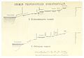 Cross-section through two systems of lakes


_p.931_-_Comparative_Heights_of_Mountains,_Places,_etc_in_the_British_Isles_-_J._Bartholomew_and_Co.jpg)
_p277.jpg)
Special cases
[edit]Please use the additional tags world, conical, and split for the special cases below.
Maps needing rotation should be tagged rotatec (to be turned clockwise), or rotatecc (to be turned counter-clockwise).
1. World maps
[edit]Please tag these with the tags world map, or map world
-
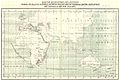
 World map
 -
 Hemisphere map
_MAP_OF_THE_WORLD_-_comp._by_Irvine.jpg)
_Map_of_THE_WORLD.jpg)
2. Non-rectangular projections
[edit]Please tag these with the tags conical map, or map conical
-
 Map on a polar projection
 -
 Map on a Cardioid projection, with an not-entirely-sound grasp of geography

_-_T4_-_S%C3%BCdliche_Hemisphaere_der_Weltkarte_des_Orontius_Finaeus_a._d._J._1531.jpg)
3. Images containing multiple maps
[edit]Please tag these with the tags split map, or map split
-
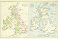 A pair of maps of the British Isles
 -
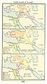
 Sketch of two river systems
 -
 Multiple nautical sketches
 -
 Multiple historical periods
_p.939_-_River_Basins_and_Tidal_Flow_of_the_British_Isles_-_J._Bartholomew_and_Co.jpg)
_1.472_Kartenskizzen_zur_Abgrenzung_der_Indianerst%C3%A4mme_entlang_des_Flusslaufes_des_Colorado_River.jpg)

_p029_THE_ERALY_EAST.jpg)
Maps
[edit]These should all be tagged with map (even the building plans)
-
 Plan of a church
 -
 Plan of a mosque
 -
 Plan of a church
 -
 Plan of a park
 -
 Plan of a garden
 -
 Plan of a cemetery
 -
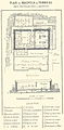
 Plan of an large-scale exhibition
 -
 Battlefield plan
 -
 Plan of a key location on a battlefield
 -
 Tudor map
 -
 17th-century city map
 -
 Medieval-style map with drawn houses
 -
 Hypothetical reconstruction
 -
 Design for an urban plan that was never built
 -
 Transport plan (geographically accurate)
 -
 Transport plan (geographically accurate)
 -
 Sketch map of a county
 -
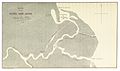
 Sketch map of a river
 -
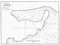 Sketch map of a bay
 -
 Sketch map of a delta
 -
 Outline plan of a new settlement
 -
 Not quite a world map
 -
 Australia with a superimposed British Isles
 -
 Map with a photograph, needing rotation
_p493_PLATTE_GROND_VAN_DE_KERK_VAN_HET_H._GRAF.jpg)
_PLAN_DE_MACP%C3%89LAL_OU_TOMBEAU_DES_PATRIARCHES_A_H%C3%89BRON.jpg)
_1.534_-_Ground_Plan_of_the_Church_of_St_Martin_Outwich,_1873.jpg)
,_p346.jpg)
,_pl._1_-_BL.jpg)
_p017_GROUND_PLAN.jpg)
_p676_Philadelphia_1876_-_PLAN_OF_CENTENNIAL_GROUNDS.jpg)

.jpg)
,_ff.98v-99_-_BL_Royal_MS_18_D_III.jpg)
_pg014_THE_DUKES_PLAN,_MADE_FROM_JAMES,_DUKE_OF_YORK,_ABOUT_1664.jpg)
_1.144_-_Plan_of_Fleet_Street,_the_Temple,_etc,_1563.jpg)
_1.015_-_Plan_of_Roman_London.jpg)
_1.496_-_Wren%27s_Plan_for_Rebuilding_London.jpg)
.jpg)
_p039_-_Inner_Circle_sketch.jpg)
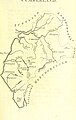
_p051_-_Cumberland.jpg)


.jpg)
_AUSTRALIA.jpg)
_p177_SCENE_OF_CHRIST%27S_TEACHINGS.jpg)
Tricky to georeference, but should still be tagged
[edit]These will be hard to georeference, but should still be tagged map
-
 Ptolemaic map
 -
 Plans of a cave system
,_ff.68v-69_-_BL_Add_MS_15760.jpg)
