Columbia River Highway Historic District
Jump to navigation
Jump to search
English: The Columbia River Highway Historic District, a linear feature running roughly parallel to the south shore of the Columbia River between Troutdale and The Dalles, Oregon, United States, is listed on the U.S. National Register of Historic Places. Presented below is a gallery of those roadway features (including bridges and tunnels), buildings, and properties identified as "major features" of the district in Appendix C of its National Register nomination file (see citation below). Single- and double-letter designators are those used as map codes in the nomination file, and similarly relate to the maps below.
Gallery of major features
[edit]-
 (A) Sandy River Bridge, No. 2019
 -
 (B) Sandy River (Stark Street) Bridge, No. 11112
 -

-
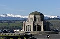
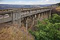
 (D) Crown Point Viaduct, No. 4524
 -
-

-
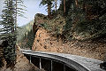
 (G) Figure Eight Loops on the Columbia River Highway
 -
 (H) Latourell Creek Bridge, No. 4527
 -

-

-
-
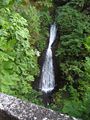
 (L) Bridal Veil Falls/Creek Bridge, No. 823
 -

-
-

-
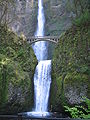
 (P) West Multnomah Falls Viaduct, No. 840
 -
-

-
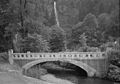
 (S) Benson Footbridge / Multnomah Falls Footbridge
 -
 (T) East Multnomah Falls Viaduct, No. 841
 -
 (U) Oneonta Creek/Gorge Bridge, No. 4542
 -
 (V) Oneonta Creek/Gorge Bridge, No. 7108A
 -
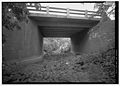
 (W) Oneonta Tunnel
 -
 (X) Horsetail Falls/Creek Bridge, No. 4543
 -
 (Y) Moffett Creek Bridge, No. 2194
 -
 (Z) Tanner Creek Bridge, No. 2062
 -
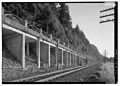
 (AA) Toothrock and Eagle Creek Viaducts
 -
 (BB) Toothrock Tunnel, No. 4555
 -
 (CC) Eagle Creek Bridge
 -
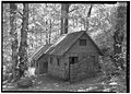
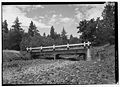
 (DD) Eagle Creek Campground and Picnic Area
 -
 (EE) Eagle Creek Overlook Picnic Area
 -
 (FF) Ruckel Creek Bridge
 -
 (GG) Gorton Creek Bridge
 -
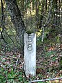 (HH) Original Mile Post Marker 58
 -
 (II) Ruthton Point Viaduct, No. 273
 -
 (JJ) Hood River Loops on the Columbia River Highway
 -
 (KK) Rock Slide Viaduct, No. 504
 -
 (LL) Mosier Twin Tunnels, No. 653
 -
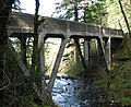
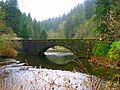
 (MM) Rock Creek Bridge, No. 203
 -
 (NN) Mosier Creek Bridge, No. 498
 -
 (OO) Memaloose Overlook
 -
 (PP) Hog Creek Canyon (Rowena Dell) Bridge, No. 523
 -
 (QQ) Dry Canyon Creek Bridge, No. 524
 -

-

-
 (TT) Abandoned Railroad Grade, Columbia River Highway
 -
 (UU) Chenoweth Creek Bridge, No. 506


_(mulDA0040a).jpg)


.jpg)


Major feature locator maps
[edit]-
 Multnomah County segment
(Features A–EE) -
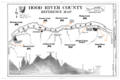 Hood River County segment
(Features FF–KK) -
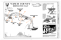 Wasco County segment
(Features LL–UU)


Base maps credit: Historic American Engineering Record (HAER) reference maps, National Park Service
Bibliographic reference
[edit]- Smith, Dwight A. (October 3, 1983). National Register of Historic Places Inventory — Nomination Form: Columbia River Highway Historic District (PDF), OCLC 12786411.