Category:Zwarteweg 5, Beltrum
Jump to navigation
Jump to search
| Object location | | View all coordinates using: OpenStreetMap |
|---|
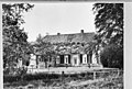
farmhouse in Berkelland, Netherlands  | |||||
| Upload media | |||||
| Instance of | |||||
|---|---|---|---|---|---|
| Location | Beltrum, Gelderland, Netherlands | ||||
| Street address |
| ||||
| Heritage designation |
| ||||
 | |||||
|
This is a category about rijksmonument number 14625
|
| Address |
|
Media in category "Zwarteweg 5, Beltrum"
The following 9 files are in this category, out of 9 total.
-
 Achterzijde - Beltrum - 20030271 - RCE.jpg 1,200 × 808; 205 KB
-
 Overzicht - Beltrum - 20030273 - RCE.jpg 1,200 × 810; 276 KB
-
 Overzicht - Beltrum - 20030274 - RCE.jpg 1,200 × 803; 220 KB
-
 Overzicht - Beltrum - 20030275 - RCE.jpg 1,200 × 798; 242 KB
-
 Situatie - Beltrum - 20030276 - RCE.jpg 1,200 × 953; 361 KB
-
 Situatie - Beltrum - 20030277 - RCE.jpg 1,200 × 945; 420 KB
-
 Situatie - Beltrum - 20030278 - RCE.jpg 1,200 × 951; 303 KB
-
 Situatie - Beltrum - 20030279 - RCE.jpg 1,200 × 962; 315 KB
-
 Voorzijde - Beltrum - 20030272 - RCE.jpg 806 × 1,200; 218 KB


