Category:Zuster A. Westerhofstraat 15, Leens
Jump to navigation
Jump to search
| Object location | | View all coordinates using: OpenStreetMap |
|---|
 | |||||
| Upload media | |||||
| Instance of | |||||
|---|---|---|---|---|---|
| Location | Leens, Leens | ||||
| Located on street |
| ||||
| Heritage designation |
| ||||
 | |||||
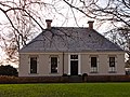
Nederlands: Nederlands Hervormde Pastorie
|
This is a category about rijksmonument number 23999
|
| Address |
|
Media in category "Zuster A. Westerhofstraat 15, Leens"
The following 5 files are in this category, out of 5 total.
-
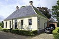 Hervormde pastorie Leens (2).jpg 4,896 × 3,264; 12.05 MB
-
 Hervormde pastorie Leens.jpg 3,558 × 2,669; 3.02 MB
-
 Nederlands Hervormde Pastorie, vooraanzicht - Leens - 20129846 - RCE.jpg 1,200 × 806; 216 KB
-
 Pastorie Leens.jpg 1,765 × 1,324; 719 KB
-
 Pastorie2 Leens.jpg 1,824 × 1,368; 470 KB
.jpg)


