
Category:Ynysawdre
village in Wales   | |||||
| Upload media | |||||
| Pronunciation audio | |||||
|---|---|---|---|---|---|
| Instance of | |||||
| Location | Bridgend County Borough, Wales | ||||
| Population |
| ||||
| Area |
| ||||
 | |||||
Subcategories
This category has the following 2 subcategories, out of 2 total.
Media in category "Ynysawdre"
The following 200 files are in this category, out of 299 total.
(previous page) (next page)-
 3-storey block of flats in Tondu - geograph.org.uk - 4200402.jpg 800 × 547; 125 KB
-
 59 units in Tondu Enterprise Centre, Tondu - geograph.org.uk - 6649019.jpg 1,600 × 1,084; 457 KB
-
 A head for heights - geograph.org.uk - 6735984.jpg 2,264 × 3,024; 1.11 MB
-
 A4064-Llangeinor Road junction - geograph.org.uk - 3047809.jpg 640 × 480; 102 KB
-
 Abergarw road bridge over GWR trackbed - geograph.org.uk - 3407942.jpg 3,648 × 2,736; 4.23 MB
-
 Aberkenfig - geograph.org.uk - 7083841.jpg 640 × 360; 83 KB
-
 Aberkenfig Pandy Park - geograph.org.uk - 6137820.jpg 640 × 480; 68 KB
-
 Aberkenfig Pandy Park - geograph.org.uk - 7055013.jpg 640 × 361; 42 KB
-
 Afon Garw at Brynmenyn - geograph.org.uk - 2803358.jpg 640 × 480; 100 KB
-
 Afon Ogwr - geograph.org.uk - 6689479.jpg 2,048 × 1,536; 1.74 MB
-
 Ascent from Brynmenyn towards Bettws - geograph.org.uk - 5617555.jpg 800 × 591; 74 KB
-
 Auto Solutions (Wales) Ltd, Tondu - geograph.org.uk - 5722519.jpg 800 × 633; 104 KB
-
 Avenue of yew trees (geograph 6736065).jpg 2,048 × 1,536; 1.98 MB
-

-
 Banners at the edge of Tondu Enterprise Centre, Tondu - geograph.org.uk - 6649088.jpg 1,600 × 1,051; 408 KB
-
 Barrier across driveway - geograph.org.uk - 6736072.jpg 2,048 × 1,536; 1.91 MB
-
 Bend in Station Approach, Tondu - geograph.org.uk - 6642252.jpg 1,600 × 994; 516 KB
-
 Bethlehem Presbyterian Chapel, Brynmenyn - geograph.org.uk - 5617599.jpg 800 × 591; 128 KB
-

-

-
 Bilingual name sign on a Tondu corner - geograph.org.uk - 5617157.jpg 800 × 673; 127 KB
-

-
 Boundary marker - geograph.org.uk - 6382102.jpg 1,759 × 1,788; 1.25 MB
-
 Bridgend Car Wash in Tondu - geograph.org.uk - 4223015.jpg 800 × 588; 90 KB
-

-

-

-
 Bryn Road telecoms cabinets, Brynmenyn - geograph.org.uk - 5621217.jpg 800 × 665; 105 KB
-

-
 Bryn Road towards a railway bridge, Tondu - geograph.org.uk - 6648896.jpg 1,600 × 1,547; 628 KB
-
 Bryngarw - geograph.org.uk - 7061613.jpg 640 × 360; 92 KB
-
 Bryngarw Park Lodge - geograph.org.uk - 2704333.jpg 2,560 × 1,920; 2.13 MB
-
 Brynmenyn - geograph.org.uk - 6566860.jpg 640 × 360; 118 KB
-
 Brynmenyn - geograph.org.uk - 7007680.jpg 640 × 360; 97 KB
-
 Brynmenyn - geograph.org.uk - 7007685.jpg 640 × 360; 77 KB
-
 Brynmenyn - geograph.org.uk - 7007687.jpg 640 × 360; 73 KB
-
 Brynmenyn - geograph.org.uk - 7007690.jpg 640 × 360; 55 KB
-
 Brynmenyn - geograph.org.uk - 7051771.jpg 640 × 360; 105 KB
-
 Brynmenyn - geograph.org.uk - 7051773.jpg 640 × 360; 104 KB
-
 Brynmenyn - geograph.org.uk - 7051775.jpg 640 × 360; 83 KB
-
 Brynmenyn - geograph.org.uk - 7060728.jpg 640 × 360; 88 KB
-
 Brynmenyn - geograph.org.uk - 7060731.jpg 640 × 360; 108 KB
-
 Brynmenyn - geograph.org.uk - 7060739.jpg 640 × 360; 132 KB
-
 Brynmenyn - geograph.org.uk - 7060742.jpg 640 × 360; 98 KB
-
 Brynmenyn Abergarw - geograph.org.uk - 7007693.jpg 640 × 360; 59 KB
-
 Brynmenyn Allotments entrance gate - geograph.org.uk - 5621276.jpg 800 × 741; 165 KB
-
 Brynmenyn Chapel - geograph.org.uk - 5258453.jpg 2,907 × 2,180; 1.27 MB
-
 Brynmenyn Common - geograph.org.uk - 2546837.jpg 640 × 440; 126 KB
-
 Bungalows in Brynmenyn - geograph.org.uk - 5621214.jpg 800 × 563; 93 KB
-
 Caelbryn Terrace houses, Brynmenyn - geograph.org.uk - 5621247.jpg 800 × 466; 70 KB
-

-
-
 Children's play area, Glan-y-nant, Tondu - geograph.org.uk - 4199931.jpg 800 × 600; 203 KB
-
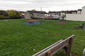
 Children's play area, Ynysawdre, Tondu - geograph.org.uk - 4200316.jpg 800 × 433; 110 KB
-
 Close view of semaphore signals, Tondu - geograph.org.uk - 4200014.jpg 766 × 800; 193 KB
-
 Clubhouse, Tondu Cricket Cluib - geograph.org.uk - 4200141.jpg 800 × 505; 120 KB
-
 Coleg Cymunedol Y Dderwen, Tondu - geograph.org.uk - 4200311.jpg 800 × 587; 119 KB
-
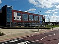 Coleg Cymunedol Y Dderwen, Tondu - geograph.org.uk - 4200312.jpg 800 × 592; 131 KB
-
 Corrugated metal hall in Brynmenyn - geograph.org.uk - 5617603.jpg 800 × 572; 116 KB
-
 Cross Street, Tondu - geograph.org.uk - 5612556.jpg 800 × 710; 151 KB
-
 Cycle Route 4 direction sign, Bryn Road, Tondu - geograph.org.uk - 6649106.jpg 1,523 × 1,488; 1.37 MB
-

-
 Demolished railway bridge - geograph.org.uk - 6691715.jpg 3,499 × 2,624; 5.87 MB
-
 Derllwyn Road, Tondu - geograph.org.uk - 4223350.jpg 800 × 538; 124 KB
-

-

-

-
 Disused platform at Brynmenyn Junction - geograph.org.uk - 2724358.jpg 1,920 × 2,560; 1.91 MB
-

-
 Disused railway, Brynmenyn - geograph.org.uk - 4097137.jpg 640 × 480; 172 KB
-
 Downstream along the Llynfi, Tondu - geograph.org.uk - 4200146.jpg 800 × 768; 253 KB
-
 Downstream along the Llynfi, Tondu - geograph.org.uk - 5617223.jpg 580 × 800; 200 KB
-

-

-
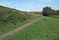
 End of cycle route, Heol-yr-ysgol, Tondu - geograph.org.uk - 4200201.jpg 800 × 501; 100 KB
-
 End of the line, near Brynmenyn - geograph.org.uk - 5708662.jpg 1,600 × 1,200; 479 KB
-

-

-
-
 Entrance to Tondu Enterprise Centre, Tondu - geograph.org.uk - 6648928.jpg 1,600 × 893; 510 KB
-
 Footbridge at Tondu railway station - geograph.org.uk - 6257349.jpg 1,024 × 780; 206 KB
-

-
 Footbridge over the River Ogmore at Sarn - geograph.org.uk - 7384969.jpg 800 × 600; 192 KB
-
 Footpath and cycle route, Tondu - geograph.org.uk - 4222960.jpg 800 × 621; 294 KB
-
 Glan-y-nant houses, Tondu - geograph.org.uk - 4200070.jpg 800 × 465; 104 KB
-
 Glan-y-nant houses, Tondu - geograph.org.uk - 5617152.jpg 800 × 539; 94 KB
-
 Glan-y-nant, Tondu - geograph.org.uk - 4199884.jpg 800 × 496; 112 KB
-
 Haulfryn houses, Brynmenyn - geograph.org.uk - 5621218.jpg 800 × 546; 85 KB
-
 Hazel Mead, Brynmenyn - geograph.org.uk - 5617618.jpg 800 × 607; 128 KB
-
 Heol Adare bungalows in Tondu - geograph.org.uk - 4200197.jpg 800 × 666; 137 KB
-
 Heol Adare houses, Tondu - geograph.org.uk - 4200314.jpg 800 × 571; 96 KB
-
 Heol Adare sewage pumping station, Tondu - geograph.org.uk - 5617235.jpg 800 × 639; 120 KB
-
 Heol Felyn Fach, Tondu - geograph.org.uk - 4223048.jpg 800 × 626; 119 KB
-
 Heol-y-bont flats in Tondu - geograph.org.uk - 4200393.jpg 800 × 716; 185 KB
-
 Heol-y-fferm, Tondu - geograph.org.uk - 4200319.jpg 800 × 535; 114 KB
-
 Heol-yr-afon, Tondu - geograph.org.uk - 4200313.jpg 800 × 635; 128 KB
-

-
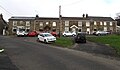
 Housing at Ynysawdre - geograph.org.uk - 7387952.jpg 800 × 600; 124 KB
-
 Icy Footpath - geograph.org.uk - 5242954.jpg 3,264 × 2,448; 4.59 MB
-

-
 Into the Llynfi Valley, Tondu - geograph.org.uk - 4223391.jpg 800 × 565; 173 KB
-
 Iron Age spear^ - geograph.org.uk - 6736009.jpg 1,406 × 2,480; 489 KB
-
 Iron Way, Tondu - geograph.org.uk - 4222963.jpg 800 × 545; 115 KB
-

-

-

-

-

-
 Junction of Station Approach and Bryn Road - geograph.org.uk - 4333854.jpg 3,552 × 2,000; 2.6 MB
-

-
 Level crossing - geograph.org.uk - 2919321.jpg 3,648 × 2,736; 3.88 MB
-
 Lichen and rust - geograph.org.uk - 6734059.jpg 1,966 × 2,621; 3.29 MB
-
 Line spur pole above a Brynmenyn corner - geograph.org.uk - 5617558.jpg 760 × 800; 103 KB
-
 Llynfi Street, Tondu - geograph.org.uk - 4223057.jpg 800 × 711; 137 KB
-
 Llynfi Valley - geograph.org.uk - 6735997.jpg 4,032 × 3,024; 7.19 MB
-
 Llynfi Valley Cycle Route, Tondu - geograph.org.uk - 4223388.jpg 800 × 613; 239 KB
-
 Llynfi Valley Railway - geograph.org.uk - 6736357.jpg 1,536 × 2,048; 1.48 MB
-

-
 Looking north along Heol Cwrdy, Ynysawdre, Sarn - geograph.org.uk - 3129809.jpg 2,288 × 1,712; 1.33 MB
-
 Lower Llansantffraid Sarn - geograph.org.uk - 6956240.jpg 640 × 360; 22 KB
-
 Maesteg Road - geograph.org.uk - 2617888.jpg 640 × 480; 58 KB
-
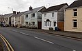
 Maesteg Road houses in Tondu - geograph.org.uk - 4222991.jpg 800 × 560; 110 KB
-
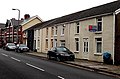
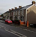
 Maesteg Road houses, Tondu - geograph.org.uk - 4223091.jpg 800 × 495; 98 KB
-
 Maesteg Road playground, Tondu - geograph.org.uk - 4223067.jpg 800 × 530; 123 KB
-
 Millennium signpost, Sarn - geograph.org.uk - 3785124.jpg 480 × 640; 172 KB
-
 Minor junction, Station Approach, Tondu - geograph.org.uk - 6641457.jpg 1,600 × 1,200; 499 KB
-
 Murco and Costcutter in Tondu - geograph.org.uk - 4223011.jpg 800 × 525; 112 KB
-
 Murco fuel tanker in Tondu - geograph.org.uk - 4223014.jpg 800 × 547; 100 KB
-
 National Cycle Route 4 at Brynmenyn - geograph.org.uk - 2636180.jpg 517 × 640; 166 KB
-
 National Cycle Route 4 at Sarn - geograph.org.uk - 7384986.jpg 588 × 800; 62 KB
-
 National Cycle Route 4 at Ynysawdre - geograph.org.uk - 3828423.jpg 480 × 640; 189 KB
-

-
 NE corner of Tondu Cricket Club's ground - geograph.org.uk - 4200105.jpg 798 × 800; 218 KB
-
 No rugby today at Pandy Park - geograph.org.uk - 2711437.jpg 2,560 × 1,920; 1.9 MB
-
 Northern arm of Andrews Close, Tondu - geograph.org.uk - 4200170.jpg 800 × 573; 125 KB
-

-
 Ogmore Junction - geograph.org.uk - 6257352.jpg 1,024 × 768; 212 KB
-
 Ogmore Junction, Tondu - geograph.org.uk - 4199980.jpg 731 × 800; 222 KB
-
 Old abutments by the Llynfi River - geograph.org.uk - 2751810.jpg 640 × 408; 155 KB
-
 Old rail bridge and the Ogmore - geograph.org.uk - 2704386.jpg 2,560 × 1,920; 2.05 MB
-

-
 Old railway abutments near Brynmenyn - geograph.org.uk - 2544665.jpg 640 × 480; 147 KB
-
 Old railway bridge - geograph.org.uk - 2919305.jpg 3,648 × 2,736; 4.19 MB
-

-
 Ordnance Survey Cut Mark - geograph.org.uk - 6954043.jpg 1,024 × 726; 351 KB
-
 Ordnance Survey Cut Mark - geograph.org.uk - 6954047.jpg 1,024 × 768; 202 KB
-
 Ordnance Survey Cut Mark - geograph.org.uk - 6954052.jpg 1,024 × 794; 274 KB
-
 Ordnance Survey Cut Mark - geograph.org.uk - 6954055.jpg 1,024 × 766; 208 KB
-
 Ordnance Survey Cut Mark - geograph.org.uk - 6954062.jpg 1,024 × 742; 345 KB
-
 Ordnance Survey Cut Mark - geograph.org.uk - 6954064.jpg 1,024 × 765; 325 KB
-
 Ordnance Survey Cut Mark - geograph.org.uk - 6954069.jpg 1,024 × 738; 239 KB
-
 Ordnance Survey Cut Mark - geograph.org.uk - 6954078.jpg 1,024 × 838; 225 KB
-
 Ordnance Survey Cut Mark - geograph.org.uk - 6954094.jpg 1,024 × 759; 130 KB
-
 Ordnance Survey Cut Mark - geograph.org.uk - 6989938.jpg 1,024 × 721; 257 KB
-
 Ordnance Survey Rivet - geograph.org.uk - 6954074.jpg 1,024 × 798; 255 KB
-
 Ordnance Survey Rivet - geograph.org.uk - 6954085.jpg 656 × 1,024; 210 KB
-

-
 Pandy Park - geograph.org.uk - 6958676.jpg 640 × 360; 31 KB
-
 Pandy Park - geograph.org.uk - 6968041.jpg 640 × 480; 83 KB
-
 Pandy Park - geograph.org.uk - 6972699.jpg 640 × 480; 56 KB
-
 Pandy Park - geograph.org.uk - 7055698.jpg 640 × 360; 27 KB
-
 Pandy Park - geograph.org.uk - 7055700.jpg 640 × 360; 22 KB
-
 Pandy Park - geograph.org.uk - 7092509.jpg 640 × 480; 65 KB
-
 Pandy Park - geograph.org.uk - 7092517.jpg 640 × 480; 75 KB
-
 Pandy Park Near Aberkenfig - geograph.org.uk - 5790814.jpg 640 × 480; 74 KB
-
 Pandy Park Sarn March 13th 2007 - geograph.org.uk - 5848107.jpg 640 × 480; 56 KB
-
 Paul's Chippy, Tondu - geograph.org.uk - 4200227.jpg 800 × 688; 139 KB
-
 Permissive Cycle Track, Tondu - geograph.org.uk - 5722635.jpg 800 × 677; 300 KB
-
 Pipes over the Ogmore cycle track in Brynmenyn - geograph.org.uk - 2387516.jpg 4,272 × 2,848; 6.87 MB
-

-

-

-
 Public footpath, Tondu - geograph.org.uk - 7391497.jpg 600 × 800; 168 KB
-

-
 Quarter milepost, Tondu - geograph.org.uk - 4199954.jpg 454 × 800; 178 KB
-
 Rail bridge at Coedtrehên - geograph.org.uk - 6734051.jpg 2,048 × 1,536; 1.22 MB
-
 Railtour at Tondu - geograph.org.uk - 4136815.jpg 3,000 × 3,000; 2.99 MB
-
 Railtour at Tondu - geograph.org.uk - 4136820.jpg 4,000 × 3,000; 4.16 MB
-
 Railtour at Tondu - geograph.org.uk - 5707040.jpg 4,537 × 3,402; 6.15 MB
-
 Railtour at Tondu - geograph.org.uk - 5707043.jpg 5,184 × 3,888; 7.05 MB
-
 Railway bridge - geograph.org.uk - 6382108.jpg 3,024 × 4,032; 7.35 MB
-
 Railway bridge and weir - geograph.org.uk - 6691723.jpg 1,536 × 2,048; 1.4 MB
-
 Railway crossing, Brynmenyn - geograph.org.uk - 3269997.jpg 480 × 640; 148 KB
-
 Railway from Tondu towards Margam - geograph.org.uk - 6642322.jpg 1,353 × 1,600; 563 KB
-
 Railway station footbridge access steps, Tondu - geograph.org.uk - 6641101.jpg 1,314 × 1,587; 416 KB
-

-
 River Ogmore - geograph.org.uk - 6402226.jpg 640 × 360; 101 KB
-
 River Ogmore - geograph.org.uk - 6955808.jpg 640 × 512; 88 KB
-
 River Ogmore - geograph.org.uk - 7101181.jpg 640 × 360; 67 KB
-
 River Ogmore - geograph.org.uk - 7101184.jpg 640 × 360; 88 KB
-
 River Ogmore - geograph.org.uk - 7101188.jpg 640 × 360; 87 KB
-
 River Way, Brynmenyn - geograph.org.uk - 5621210.jpg 800 × 618; 107 KB
-
 RJD Motor Services in Tondu - geograph.org.uk - 4200114.jpg 800 × 582; 195 KB
-
 RJD Motor Services, Tondu - geograph.org.uk - 6648922.jpg 1,443 × 1,094; 420 KB
-
 Road towards Iron Way, Tondu - geograph.org.uk - 5722616.jpg 800 × 517; 82 KB
-

-

-
 Row of houses, Bryn Road, Brynmenyn - geograph.org.uk - 5621211.jpg 800 × 674; 103 KB
-

-
 Row of six houses, Maesteg Road, Tondu - geograph.org.uk - 5613272.jpg 781 × 800; 114 KB


_Ltd,_Tondu_-_geograph.org.uk_-_5722519.jpg)
.jpg)


_-_geograph.org.uk_-_7391491.jpg)


