Category:Yellowhead Lake
Jump to navigation
Jump to search
| Object location | | View all coordinates using: OpenStreetMap |
|---|
lake in British Columbia, Canada  | |||||
| Upload media | |||||
| Instance of | |||||
|---|---|---|---|---|---|
| Located in protected area | |||||
| Location | British Columbia, Canada | ||||
| Elevation above sea level |
| ||||
| Basin country | |||||
 | |||||
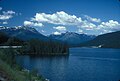
English: Yellowhead Lake is an irregularly shaped lake that is located about 3.7 km southwest of Yellowhead Pass within the boundaries of Mount Robson Provincial Park. It is on the lower reaches of Yellowhead Creek, a large creek that flows into the upper Fraser River above Moose Lake.
Media in category "Yellowhead Lake"
The following 13 files are in this category, out of 13 total.
-
 Mountain View - panoramio (1).jpg 3,264 × 1,836; 1.46 MB
-

-

-

-

-
 Yellowhead Lake - Mount Robson Provincial Park, British Columbia, Canada - July 1990.jpg 5,000 × 7,500; 25.53 MB
-

-
 Yellowhead Lake, August 1974 01.jpg 3,342 × 2,230; 7.31 MB
-
 Yellowhead Lake, August 1974 02.jpg 3,328 × 2,249; 7.18 MB
-
 Yellowhead Lake, August 1974 03.jpg 3,330 × 2,251; 8 MB
-
 Yellowhead Lake, August 1974 04.jpg 3,332 × 2,220; 7.5 MB
-
 YELLOWHEAD LAKE, MT. ROBSON PROVINCIAL PARK, B.C..jpg 5,351 × 3,630; 1.42 MB
-
 Yellowhead Lake.jpg 7,187 × 3,084; 1.89 MB
.jpg)
.jpg)
.jpg)
.jpg)
.jpg)


