Category:Yakima County, Washington
Jump to navigation
Jump to search
Counties of Washington (state): Adams · Asotin · Benton · Chelan · Clallam · Clark · Columbia · Cowlitz · Douglas · Ferry · Franklin · Garfield · Grant · Grays Harbor · Island · Jefferson · King · Kitsap · Kittitas · Klickitat · Lewis · Lincoln · Mason · Okanogan · Pacific · Pend Oreille · Pierce · San Juan · Skagit · Skamania · Snohomish · Spokane · Stevens · Thurston · Wahkiakum · Walla Walla · Whatcom · Whitman · Yakima
county in the state of Washington, United States   | |||||
| Upload media | |||||
| Instance of | |||||
|---|---|---|---|---|---|
| Named after | |||||
| Location | Washington, Pacific Northwest, Washington, Pacific States Region | ||||
| Capital | |||||
| Inception |
| ||||
| Population |
| ||||
| Area |
| ||||
| official website | |||||
 | |||||
Subcategories
This category has the following 45 subcategories, out of 45 total.
A
- Ahtanum Ridge (3 F)
B
- Battle of Two Buttes (7 F)
- Bumping Lake (1 P, 6 F)
C
- Cowiche Canyon (6 F)
F
G
- Grandview, Washington (23 F)
I
- Irrigation canals, Parker (5 F)
J
- Johnsons Orchards Fruit (13 F)
M
- Mabton, Washington (8 F)
N
O
S
T
U
- Umtanum Ridge (1 P, 33 F)
- Union Gap, Washington (6 F)
W
- Wapato, Washington (16 F)
- White Pass (Washington) (19 F)
Y
- Yakima Ridge (2 F)
Z
Media in category "Yakima County, Washington"
The following 136 files are in this category, out of 136 total.
-

-
-
-

-

-
 A pond on the Greenway covered in a temporary bloom of tiny water plants - panoramio.jpg 2,592 × 1,552; 795 KB
-

-
 Aerial - Wenas Valley northwest of Selah, WA 01 (9793247586).jpg 2,848 × 4,288; 3.85 MB
-
 Aerial - Wenas Valley northwest of Selah, WA 01 - equalized (9793282574).jpg 2,848 × 4,288; 11.2 MB
-
 Aerial - Yakima River northeast of Selah, WA 03 (9792722914).jpg 2,848 × 4,288; 4.09 MB
-
 Aerial - Yakima River northeast of Selah, WA 03 - white balanced (9792786584).jpg 2,848 × 4,288; 9.54 MB
-
 Ahtanum Pioneer Church on Ahtanum Road 11-18-2018.jpg 2,016 × 1,512; 363 KB
-
 Almost to Lunch Counter - Flickr - brewbooks.jpg 4,135 × 1,881; 2.86 MB
-
 Ascending Cowiche Mountain Trail - Flickr - brewbooks.jpg 4,608 × 3,456; 5.46 MB
-
 Bird Creek Meadow Waterfall - panoramio.jpg 1,260 × 1,680; 708 KB
-
 Botany Break - Flickr - brewbooks (1).jpg 4,288 × 2,416; 2.99 MB
-
 Bridge Through Boulder Cave (106990823).jpeg 909 × 1,367; 294 KB
-
 Camp at Lunch Counter - Flickr - brewbooks.jpg 4,288 × 2,416; 2.64 MB
-
 Chinook Pass - panoramio.jpg 1,920 × 1,080; 689 KB
-
 Classic U shaped Valley on east side of Chinook Pass (1456234727).jpg 1,024 × 768; 701 KB
-
 Cloudy Sky (19741406142).jpg 5,221 × 3,543; 10.61 MB
-
 Cold Springs Campground - Flickr - brewbooks.jpg 4,288 × 2,416; 2.99 MB
-
 Cow Canyon - panoramio.jpg 2,304 × 1,536; 1.2 MB
-
 Cowiche Buggy 1 (197630455).jpeg 2,048 × 1,365; 858 KB
-
 Cowichie Canyon Trail - panoramio.jpg 1,286 × 415; 263 KB
-
 Elk near Fish Lake - Flickr - brewbooks.jpg 4,288 × 3,216; 3.59 MB
-
 Euclid, Yakima County (CURTIS 900) panorama.jpg 1,991 × 598; 327 KB
-
 Euclid, Yakima County (CURTIS 901).jpeg 768 × 610; 78 KB
-
 Euclid, Yakima County (CURTIS 902).jpeg 768 × 612; 72 KB
-
 Euclid, Yakima County (CURTIS 903).jpeg 768 × 621; 68 KB
-
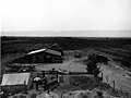 Farm in Yakima County, Washington, ca 1910 (WASTATE 183).jpeg 768 × 574; 71 KB
-
 Farm in Yakima County, Washington, ca 1910 (WASTATE 22).jpeg 768 × 578; 81 KB
-
 Farm in Yakima County, Washington, ca 1910 (WASTATE 821).jpeg 768 × 576; 60 KB
-
 Flying H Youth Ranch - panoramio.jpg 1,920 × 1,080; 792 KB
-

-
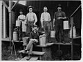 Fruit pickers, 1911 (MOHAI 6214).jpg 939 × 700; 80 KB
-
 Heading up east side of Chinook Pass (1457102948).jpg 1,024 × 768; 686 KB
-
 Highland Quick Stop, Cowiche, WA. U.S.A - panoramio.jpg 2,592 × 1,936; 2.08 MB
-
 Hop Field Near Moxee, WA. east of Yakima. (10933499164).jpg 1,536 × 1,024; 482 KB
-
 House cleaning.jpg 640 × 479; 61 KB
-

-
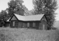
 Indian Methodist Episcopal Church, White Swan, Yakima County, WA HABS WASH,39-WHIT,1-1.tif 3,526 × 5,000; 16.82 MB
-
-
-
 Juglans species round Rattlesnake Hills Washington.jpg 2,620 × 2,152; 1.59 MB
-
 Kevin and Robert taking a break - Flickr - brewbooks.jpg 4,288 × 2,416; 4.23 MB
-
 Kevin checking sunset - Flickr - brewbooks.jpg 4,288 × 2,416; 2.55 MB
-

-

-

-

-
-

-
-
-
-
-

-
 Leaving Mount Adams - Flickr - brewbooks (1).jpg 4,288 × 2,416; 3.7 MB
-
 Leaving Mount Adams - Flickr - brewbooks.jpg 4,288 × 2,416; 4.47 MB
-
 Leech Lake, start of trip - Flickr - brewbooks.jpg 4,288 × 2,693; 4.86 MB
-
 Linda and Roger heading up - Flickr - brewbooks.jpg 4,288 × 2,416; 1.91 MB
-
 Linda and Roger on the way to Lunch Counter - Flickr - brewbooks.jpg 4,288 × 2,416; 2.6 MB
-
 Little Mt. Adams - panoramio.jpg 1,260 × 1,680; 339 KB
-
 Looking down from our camp at Lunch Counter - Flickr - brewbooks.jpg 4,288 × 2,416; 2.33 MB
-

-
 Me, Jeff, and Chad starting out - Flickr - brewbooks.jpg 3,516 × 2,512; 2.4 MB
-

-
 Mountain Ash along Chinook Pass (1456235461).jpg 1,024 × 768; 953 KB
-

-
 Naches River (3935891405).jpg 1,632 × 1,224; 1.96 MB
-
 Nestotus stenophyllus (Narrowleaf Goldenweed) - Flickr - brewbooks.jpg 4,000 × 2,699; 4.13 MB
-

-
 Nothocalais troximoides (False Agoseris) - Flickr - brewbooks (1).jpg 2,027 × 2,418; 1.9 MB
-
 Nothocalais troximoides (False Agoseris) - Flickr - brewbooks.jpg 2,318 × 1,974; 2.14 MB
-
 Old control panel, Yakima Trolly (10900519403).jpg 1,536 × 1,024; 259 KB
-
 On the News!.png 1,219 × 1,248; 2.33 MB
-
 Orchard, Yakima County, Washington, ca 1910 (WASTATE 123).jpeg 768 × 580; 104 KB
-
 Our camp at Fish Lake - Flickr - brewbooks.jpg 4,288 × 2,588; 3.49 MB
-
 Our camp at Lunch Counter - Flickr - brewbooks (1).jpg 4,288 × 2,416; 3.08 MB
-
 Our camp at Lunch Counter - Flickr - brewbooks.jpg 4,288 × 2,416; 4.27 MB
-
 Phoenicaulis cheiranthoidesDagger Pod - Flickr - brewbooks.jpg 3,539 × 2,377; 2.65 MB
-
 Potluck (8167936623).jpg 1,600 × 1,067; 1.04 MB
-
 Prune orchard, Yakima County, Washington, nd (WASTATE 936).jpeg 768 × 613; 136 KB
-
 Rainbow at the end of hike - Flickr - brewbooks.jpg 3,576 × 2,942; 4.2 MB
-
 Raising Mast with Yagi Antenna - Flickr - brewbooks (1).jpg 3,264 × 2,448; 3.46 MB
-
 Raising Mast with Yagi Antenna - Flickr - brewbooks.jpg 2,448 × 3,264; 3.21 MB
-
 Rattlesnake Ridge landslide zone on I-82.jpg 4,608 × 2,936; 3.5 MB
-
 Reflection in a tarn - Flickr - brewbooks.jpg 2,998 × 4,164; 3.31 MB
-
 Rhizocarpon geographicum (map lichen) - Flickr - brewbooks (1).jpg 4,288 × 2,416; 2.75 MB
-
 Rhizocarpon geographicum (map lichen) - Flickr - brewbooks.jpg 2,157 × 2,024; 1.51 MB
-
 Ridge of Basalmroot - Flickr - brewbooks.jpg 4,608 × 3,456; 4.62 MB
-
 Rock Quarry west of Yakima (1457156842).jpg 1,024 × 768; 714 KB
-
 Roger and Linda taking a break - Flickr - brewbooks.jpg 4,288 × 2,416; 2.45 MB
-
 Roger in camp - the view was great - Flickr - brewbooks.jpg 4,288 × 2,416; 3.21 MB
-
 Roger is happy - Flickr - brewbooks.jpg 4,288 × 2,416; 4.35 MB
-
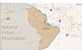 Satus location in Yakama Indian Reservation.svg 1,602 × 972; 1.53 MB
-
 Selah - panoramio.jpg 6,485 × 1,894; 10.08 MB
-
 Setting up the 28 foot Mast - Flickr - brewbooks.jpg 3,264 × 2,448; 2.93 MB
-
 Shadow of Mount Adams - Flickr - brewbooks.jpg 4,288 × 2,416; 1.87 MB
-
 Smelowskia calycina (I think) - Flickr - brewbooks.jpg 4,288 × 2,416; 2.55 MB
-
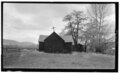
 St Joseph's Mission - Tampico Washington - three point perspective.png 4,630 × 3,216; 10.03 MB
-
 St Joseph's Mission - Tampico Washington.png 4,640 × 2,670; 8.13 MB
-
 St Josephs Mission - Tampico Washington - cropped.png 3,203 × 2,135; 4.58 MB
-

-

-
-

-
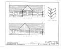
 St. Joseph's Mission, Ahtanum Valley, Tampico, Yakima County, WA HABS WASH,39-TAMP.V,1-1.tif 5,000 × 3,080; 14.69 MB
-
 St. Joseph's Mission, Ahtanum Valley, Tampico, Yakima County, WA HABS WASH,39-TAMP.V,1-2.tif 5,000 × 3,748; 17.87 MB
-
 St. Josephs Mission - Tampico.jpg 589 × 339; 41 KB
-
 Starting on the Snow, on the way to Lunch Counter - Flickr - brewbooks.jpg 4,288 × 2,416; 1.86 MB
-

-

-
 Taking a Break on the Way to Lunch Counter - Flickr - brewbooks.jpg 4,288 × 2,416; 2.51 MB
-
 Tate's Food Center, Cowiche, Wa, about 1968.jpg 746 × 571; 360 KB
-
 Taxodium species round sunnyside Washington.jpg 2,448 × 2,132; 1.53 MB
-
-
 The first breath of Autumn wafts through the Yakima Greenway - panoramio.jpg 2,592 × 1,552; 1.35 MB
-
 Tieton (8167936099).jpg 1,200 × 1,600; 791 KB
-
 Tuning Up - Flickr - brewbooks.jpg 3,264 × 2,448; 2.87 MB
-
 Up a steep bit - Flickr - brewbooks.jpg 4,288 × 2,416; 4.08 MB
-
 USA Yakima County, Washington age pyramid.svg 520 × 600; 8 KB
-
 Veratrum viride (Green false hellebore) - Flickr - brewbooks.jpg 2,686 × 2,280; 2.03 MB
-
 View ascending Cowiche Mountain - Flickr - brewbooks.jpg 4,608 × 3,456; 4.78 MB
-
 Weather Coming into Cow Canyon - panoramio.jpg 2,304 × 1,536; 971 KB
-
 West of Vernita Bridge (9567208030).jpg 2,304 × 1,728; 781 KB
-
 Wheat field, Yakima County, Washington, ca 1920 (WASTATE 214).jpeg 768 × 563; 68 KB
-
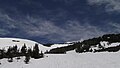
 Whiteout - Flickr - brewbooks.jpg 4,288 × 2,416; 1.1 MB
-
-
 Wrong turn at albuquerque - panoramio.jpg 1,600 × 1,200; 561 KB
-
 Yakima Canyon (1457158552).jpg 1,024 × 768; 789 KB
-
 Yakima County.jpg 1,200 × 796; 459 KB
-
 Yakima River (1457159118).jpg 1,024 × 768; 894 KB
-
 Yakima river.jpg 1,785 × 2,700; 1.12 MB
-
 Yakima3 (9564368941).jpg 2,304 × 1,728; 753 KB


.jpg)

.jpeg)
.jpg)
.jpg)
.jpg)
.jpg)


.jpg)
.jpeg)


.jpg)
.jpg)


.jpeg)

.jpeg)
.jpeg)
.jpeg)
.jpeg)
.jpeg)
.jpeg)

.jpeg)
.jpg)
.jpg)

.jpg)


.jpeg)
.jpeg)


.jpg)


.jpg)
.jpeg)
.jpg)
_-_Flickr_-_brewbooks.jpg)
.jpeg)
_-_Flickr_-_brewbooks_(1).jpg)
_-_Flickr_-_brewbooks.jpg)
.jpg)

.jpeg)

.jpg)


.jpg)
.jpeg)

.jpg)


_-_Flickr_-_brewbooks_(1).jpg)
_-_Flickr_-_brewbooks.jpg)

.jpg)


_-_Flickr_-_brewbooks.jpg)


.jpg)
.jpeg)


.jpg)

.jpg)


_-_Flickr_-_brewbooks.jpg)


.jpg)
.jpeg)

.jpeg)

.jpg)

.jpg)

.jpg)
_panorama.jpg)