Category:Wyke Viaduct
Jump to navigation
Jump to search
| Object location | | View all coordinates using: OpenStreetMap |
|---|
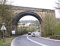
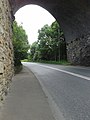
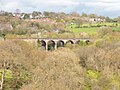
English: Wyke Viaduct or Red Lion Viaduct, across the Wyke valley just north of Bailiff Bridge station on the disused Pickle Bridge Line, West Yorkshire. It had 22 arches until 1987, when all but the southernmost eight arches were demolished due to mining subsidence.
railway bridge in West Yorkshire, UK  | |||||
| Upload media | |||||
| Instance of | |||||
|---|---|---|---|---|---|
| Location |
| ||||
| Crosses | |||||
| Carries | |||||
| Heritage designation |
| ||||
| Date of official opening |
| ||||
| Date of official closure |
| ||||
| Dissolved, abolished or demolished date |
| ||||
 | |||||
Media in category "Wyke Viaduct"
The following 20 files are in this category, out of 20 total.
-
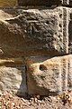 Benchmark on railway bridge over A58 - geograph.org.uk - 6019820.jpg 683 × 1,024; 298 KB
-
 Bradford - Wyke Viaduct - 20221025125124.jpeg 3,024 × 4,032; 3.81 MB
-
 Bridge BRB-BHS 03 - Leeds Road, Wyke - geograph.org.uk - 772278.jpg 640 × 495; 85 KB
-
 Dismantled railway crossing A58 nr Wyke - geograph.org.uk - 57161.jpg 640 × 480; 135 KB
-
 Disused Railway Bridge over the A58 at Wyke - geograph.org.uk - 4028864.jpg 1,920 × 2,560; 2.3 MB
-
 Disused viaduct - geograph.org.uk - 2361790.jpg 640 × 480; 105 KB
-
 Disused viaduct crossing Whitehall Road (A58) - geograph.org.uk - 6416921.jpg 2,000 × 1,316; 1.72 MB
-
 Disused viaduct crossing Whitehall Road (A58) - geograph.org.uk - 6416941.jpg 2,000 × 1,331; 2.86 MB
-
 End Of The Line - geograph.org.uk - 1407547.jpg 640 × 480; 120 KB
-
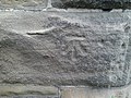 Ordnance Survey Cut Mark - geograph.org.uk - 4029274.jpg 2,560 × 1,920; 2.78 MB
-

-
 Ramblers near Lightcliffe - geograph.org.uk - 2258445.jpg 1,024 × 704; 383 KB
-
 The Wyke Viaduct - geograph.org.uk - 91663.jpg 640 × 480; 100 KB
-
 Truncated viaduct from the Calderdale Way - geograph.org.uk - 2849517.jpg 3,072 × 2,304; 1.02 MB
-
 Viaduct arch off Bradford Road, Wyke - geograph.org.uk - 187876.jpg 467 × 640; 111 KB
-

-

-

-
 Wyke Viaduct from Lightcliffe.jpg 5,184 × 3,888; 5.09 MB
-
 Wyke-viaduct-by-Dr-Neil-Clifton.jpg 640 × 537; 59 KB


_-_geograph.org.uk_-_6416921.jpg)
_-_geograph.org.uk_-_6416941.jpg)


Categories:
- 1870s architecture in West Yorkshire
- Bailiff Bridge
- Pickle Bridge Line
- Railway viaducts in West Yorkshire
- Stone arch bridges in West Yorkshire
- Wyke, Bradford
- Disused railway bridges in West Yorkshire
- Railway bridges in the Metropolitan Borough of Calderdale
- Railway bridges in the City of Bradford
- Bradford-Calderdale boundary