Category:World War I memorial in Vyšní Lhoty
Jump to navigation
Jump to search
| Object location | | View all coordinates using: OpenStreetMap |
|---|
.JPG) | |||||
| Upload media | |||||
| Instance of | |||||
|---|---|---|---|---|---|
| Commemorates | |||||
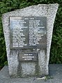
| Location | Vyšní Lhoty, Frýdek-Místek District, Moravian-Silesian Region, Czechia | ||||
 | |||||
Media in category "World War I memorial in Vyšní Lhoty"
The following 4 files are in this category, out of 4 total.
-
 Vyšní Lhoty, památník obětem 1. světové války (1).JPG 2,548 × 3,441; 5.36 MB
-
 Vyšní Lhoty, památník obětem 1. světové války (2).JPG 3,282 × 2,432; 5.36 MB
-
 Vyšní Lhoty, památník obětem 1. světové války (3).JPG 2,504 × 2,820; 4.5 MB
-
 Vyšní Lhoty, památník obětem 1. světové války (4).JPG 3,147 × 2,626; 5.08 MB
.JPG)
.JPG)
.JPG)