Category:World War I memorial Stendell
Jump to navigation
Jump to search
| Object location | | View all coordinates using: OpenStreetMap |
|---|
war memorial in Brandenburg state, Germany  | |||||
| Upload media | |||||
| Instance of | |||||
|---|---|---|---|---|---|
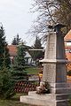
| Location | Stendell, Schwedt/Oder, Uckermark District, Brandenburg, Germany | ||||
| Street address |
| ||||
 | |||||
Deutsch: Ansichten des Gefallenendenkmals für den Ersten Weltkrieg in Stendell , Stadt Schwedt , Landkreis Uckermark , Land Brandenburg, Deutschland.
English: Pictures of the World War I memorial in Stendell , Schwedt municipality , Uckermark district, Brandenburg state, Germany.
Français : Photos du monument aux morts de la Premiére Guerre Mondiale à Stendell , ville de Schwedt , arrondissement de Uckermark , état fédéral de Brandebourg, Allemagne
Español: Vistas del monumento a los caidos de la Primera Guerra Mundial en Stendell , ciudad de Schwedt , distrito de Uckermark , estado federado de Brandeburgo, Alemania
Adress: Stendeller Ring 2
Media in category "World War I memorial Stendell"
The following 3 files are in this category, out of 3 total.
-
 Gefallenendenkmal WK I Stendell 2019 Namenstafel.jpg 3,648 × 4,864; 6.99 MB
-
 Gefallenendenkmal WK I Stendell 2019 NE.jpg 3,648 × 4,864; 6.57 MB
-
 Stendell Denkmal.jpg 399 × 599; 62 KB

