Category:Woodthorpe, Nottinghamshire
Jump to navigation
Jump to search
English: Woodthorpe is a suburb of Arnold, in the unparished area of Arnold, in the Gedling district, in the county of Nottinghamshire, England.
area in Arnold, Nottinghamshire, UK  | |||||
| Upload media | |||||
| Instance of | |||||
|---|---|---|---|---|---|
| Location | Arnold, Gedling, Nottinghamshire, East Midlands, England | ||||
 | |||||
Subcategories
This category has only the following subcategory.
Media in category "Woodthorpe, Nottinghamshire"
The following 78 files are in this category, out of 78 total.
-
 56003 Woodthorpe.jpg 2,048 × 1,398; 364 KB
-
 Arndale Road, Sherwood - geograph.org.uk - 3418666.jpg 1,024 × 768; 177 KB
-
 Beacon and "pitch and putt" - geograph.org.uk - 5852169.jpg 1,280 × 853; 289 KB
-
 Bench mark, Woodthorpe Grange - geograph.org.uk - 4122870.jpg 960 × 1,280; 396 KB
-
 Benchmark on bridge, Edwards Lane - geograph.org.uk - 2911708.jpg 683 × 1,024; 317 KB
-

-
 Benchmark on No. 1 Tithby Drive - geograph.org.uk - 6456556.jpg 622 × 1,024; 200 KB
-
 Benchmark on No. 24 Tithby Drive - geograph.org.uk - 6456569.jpg 683 × 1,024; 193 KB
-

-
 Breckhill Road - geograph.org.uk - 1144681.jpg 475 × 640; 99 KB
-
 Café in Woodthorpe Grange Park - geograph.org.uk - 5852172.jpg 1,280 × 719; 346 KB
-
 Cavendish Vale, Sherwood - geograph.org.uk - 3234199.jpg 1,024 × 768; 156 KB
-
 Day Brook Recreation Ground, Nottingham NG5 - geograph.org.uk - 4067325.jpg 3,483 × 2,471; 1.76 MB
-
 Day Brook Recreation Ground, Nottingham NG5 - geograph.org.uk - 4067338.jpg 2,800 × 3,263; 1.8 MB
-
 Day Brook Recreation Ground, Nottingham NG5 - geograph.org.uk - 4067360.jpg 3,072 × 2,769; 1.71 MB
-
 Day Brook Recreation Ground, Nottingham NG5 - geograph.org.uk - 4067389.jpg 3,160 × 2,307; 1.68 MB
-
 Day Brook Recreation Ground, Nottingham NG5 - geograph.org.uk - 4067397.jpg 3,663 × 2,653; 1.82 MB
-
 Day Brook Recreation Ground, Nottingham NG5 - geograph.org.uk - 4067408.jpg 3,490 × 2,212; 1.54 MB
-
 Day Brook Recreation Ground, Nottingham NG5 - geograph.org.uk - 4067422.jpg 3,184 × 2,427; 1.24 MB
-
 Day Brook Recreation Ground, Nottingham NG5 - geograph.org.uk - 4067425.jpg 3,360 × 2,537; 1.34 MB
-
 Daybrook, Ribblesdale Road - geograph.org.uk - 3529564.jpg 1,024 × 1,024; 1.17 MB
-
 Ennerdale Road, Sherwood - geograph.org.uk - 3418662.jpg 1,024 × 768; 157 KB
-

-
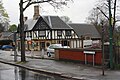 Fiveways pub, Edwards Lane - geograph.org.uk - 2911714.jpg 1,024 × 683; 191 KB
-
 Joyce Avenue, Nottingham, NG5 - geograph.org.uk - 5635737.jpg 2,950 × 2,187; 1.9 MB
-
 Mansfield Road, Nottingham (A60) - geograph.org.uk - 1949551.jpg 640 × 480; 74 KB
-
 Mosaic panels in Woodthorpe Grange Park - geograph.org.uk - 5843321.jpg 1,280 × 719; 353 KB
-
 Nos. 24 and 22 Tithby Drive - geograph.org.uk - 6456574.jpg 1,024 × 660; 143 KB
-
 Nos. 65 and 67 Woodthorpe Drive - geograph.org.uk - 6456742.jpg 1,024 × 676; 163 KB
-
 Nos.1 and 3 Tithby Drive - geograph.org.uk - 6456562.jpg 1,024 × 685; 177 KB
-
 Nottingham - NG5 - geograph.org.uk - 2859230.jpg 640 × 480; 71 KB
-
 Nottingham - NG5 - geograph.org.uk - 2859261.jpg 640 × 480; 94 KB
-
 Nottingham - NG5 - geograph.org.uk - 2859307.jpg 640 × 480; 118 KB
-
 Nottingham - NG5 - geograph.org.uk - 2859334.jpg 640 × 480; 108 KB
-
 Nottingham - NG5 - geograph.org.uk - 2859352.jpg 640 × 480; 90 KB
-
 Nottingham - NG5 - geograph.org.uk - 2859381.jpg 480 × 640; 73 KB
-
 Nottingham - NG5 - geograph.org.uk - 2859477.jpg 640 × 480; 108 KB
-
 Nottingham - Sherwood - geograph.org.uk - 2859212.jpg 640 × 480; 81 KB
-
 Nottingham - Sherwood NG5 - geograph.org.uk - 2851216.jpg 640 × 480; 86 KB
-
 Nottingham - Sherwood NG5 - geograph.org.uk - 2851271.jpg 640 × 480; 87 KB
-
 Nottingham - Sherwood NG5 - geograph.org.uk - 2851298.jpg 640 × 480; 102 KB
-
 Nottingham - Sherwood NG5 - geograph.org.uk - 2851325.jpg 480 × 640; 87 KB
-
 Nottingham - Sherwood NG5 - geograph.org.uk - 2851372.jpg 640 × 480; 70 KB
-
 Nottingham Woodthorpe - geograph.org.uk - 5646820.jpg 4,608 × 3,456; 4.25 MB
-
 Nottingham, NG5 - Sherwood - geograph.org.uk - 3235999.jpg 3,666 × 2,476; 1.98 MB
-
 Nottingham, NG5 - Sherwood - geograph.org.uk - 3236011.jpg 2,739 × 3,831; 2.04 MB
-
 Nottingham, NG5 - Sherwood - geograph.org.uk - 3236025.jpg 2,757 × 4,027; 2.28 MB
-
 Nottingham, NG5 - Sherwood - geograph.org.uk - 3236041.jpg 3,586 × 2,460; 1.38 MB
-
 Nottingham, NG5 - Sherwood - geograph.org.uk - 3236079.jpg 3,494 × 2,523; 1.57 MB
-
 Nottingham, NG5 - Sherwood - geograph.org.uk - 3236087.jpg 3,948 × 2,363; 1.83 MB
-
 Nottingham, NG5 - Sherwood - geograph.org.uk - 3236107.jpg 3,642 × 2,664; 2.09 MB
-
 Nottingham, NG5 - Sherwood - geograph.org.uk - 3236135.jpg 2,742 × 2,530; 1.86 MB
-
 Nottingham, NG5 - Sherwood - geograph.org.uk - 3236162.jpg 3,871 × 2,302; 1.96 MB
-
 Nottingham, NG5 - Sherwood - geograph.org.uk - 3236167.jpg 3,938 × 2,563; 2.08 MB
-
 Nottingham, NG5 - Sherwood - geograph.org.uk - 3236178.jpg 3,146 × 2,379; 1.56 MB
-
 Nottingham, NG5 - Sherwood - geograph.org.uk - 3236244.jpg 3,857 × 2,707; 1.97 MB
-
 Ribblesdale Road, Day Brook Rain Gardens - geograph.org.uk - 3529732.jpg 1,200 × 908; 1.58 MB
-
 Ribblesdale Road, Sherwood - geograph.org.uk - 3418658.jpg 1,024 × 768; 175 KB
-
 Ribblesdale Road, twitchel to Valley Road - geograph.org.uk - 3529719.jpg 944 × 1,200; 1.73 MB
-
 Sherwood, NG5, Nottingham. - geograph.org.uk - 3509125.jpg 3,441 × 2,502; 1.4 MB
-
 The Firs - geograph.org.uk - 1870007.jpg 800 × 599; 145 KB
-
 The sign of The Vale - geograph.org.uk - 5852067.jpg 719 × 1,280; 126 KB
-
 Valley Road Park Flood Plain, Nottingham NG5 - geograph.org.uk - 4067687.jpg 3,714 × 2,441; 1.4 MB
-
 Valley Road Park Flood Plain, Nottingham NG5 - geograph.org.uk - 4067708.jpg 2,890 × 3,345; 1.88 MB
-
 Valley Road Park, Nottingham NG5 - geograph.org.uk - 4067726.jpg 2,897 × 3,614; 2.04 MB
-
 Valley Road Park, Nottingham NG5 - geograph.org.uk - 4067736.jpg 3,570 × 2,764; 1.86 MB
-
 Valley Road Park, Nottingham, NG5 - geograph.org.uk - 4067749.jpg 2,712 × 2,492; 1.54 MB
-
 View along Woodthorpe Drive - geograph.org.uk - 6108657.jpg 1,024 × 683; 188 KB
-
 View from the bottom of Sherwood Vale - geograph.org.uk - 3234180.jpg 1,024 × 768; 145 KB
-
 Woodthorpe flats from Mapperley Rise - geograph.org.uk - 3224034.jpg 1,024 × 768; 170 KB
-
 Woodthorpe flats from Sherwood Vale - geograph.org.uk - 3234194.jpg 1,024 × 768; 125 KB
-
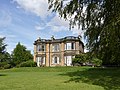
 Woodthorpe Grange - geograph.org.uk - 4122874.jpg 1,280 × 918; 345 KB
-
 Woodthorpe Grange - geograph.org.uk - 4122876.jpg 1,280 × 1,280; 404 KB
-
 Woodthorpe Grange - geograph.org.uk - 5646833.jpg 4,608 × 3,456; 3.78 MB
-
 Woodthorpe Grange Park - geograph.org.uk - 1869976.jpg 800 × 595; 201 KB
-
 Woodthorpe Grange Park - geograph.org.uk - 5646827.jpg 4,608 × 3,456; 4.56 MB
-
 Woodthorpe Grange Park - geograph.org.uk - 5646843.jpg 4,608 × 3,456; 4.35 MB
-
 Woodthorpe Grange, the west front - geograph.org.uk - 4122875.jpg 1,280 × 960; 399 KB


_-_geograph.org.uk_-_1949551.jpg)


