Category:Wohnhaus (Maggenberg 3, Tafers)
Jump to navigation
Jump to search
| Object location | | View all coordinates using: OpenStreetMap |
|---|
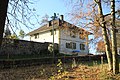
residential building and part of a building ensemble in Tafers in the canton of Fribourg  | |||||
| Upload media | |||||
| Instance of | |||||
|---|---|---|---|---|---|
| Part of | |||||
| Location | Tafers, Sense District, Canton of Fribourg, Switzerland | ||||
| Street address |
| ||||
| Heritage designation |
| ||||
 | |||||
Media in category "Wohnhaus (Maggenberg 3, Tafers)"
This category contains only the following file.
-
 Schloss Maggenberg 12 Gärtnerhaus.JPG 4,752 × 3,168; 4.06 MB