Category:Wiverton Hall
Jump to navigation
Jump to search
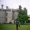
English country house near Tithby, Nottinghamshire, England, UK  | |||||
| Upload media | |||||
| Instance of | |||||
|---|---|---|---|---|---|
| Location | Wiverton Hall, Rushcliffe, Nottinghamshire, East Midlands, England | ||||
| Heritage designation |
| ||||
| Significant event |
| ||||
 | |||||
Subcategories
This category has only the following subcategory.
Media in category "Wiverton Hall"
The following 13 files are in this category, out of 13 total.
-
 Bingham Road near Langar - geograph.org.uk - 2255575.jpg 1,280 × 854; 369 KB
-
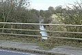
 Footpath at Wiverton Smite Bridge - geograph.org.uk - 2255593.jpg 1,280 × 854; 588 KB
-
 In the Vale of Belvoir - geograph.org.uk - 2255577.jpg 1,280 × 854; 604 KB
-
 River Smite - geograph.org.uk - 2255581.jpg 1,280 × 854; 765 KB
-
 Road to Smite Hill Farm - geograph.org.uk - 2255584.jpg 1,280 × 854; 613 KB
-
 Smite tributary - geograph.org.uk - 1045560.jpg 640 × 427; 77 KB
-
 Stroom Dyke - geograph.org.uk - 2255591.jpg 1,280 × 854; 604 KB
-
 Wiverton Hall - geograph.org.uk - 1045557.jpg 640 × 427; 66 KB
-
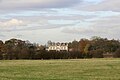 Wiverton Hall - geograph.org.uk - 1045558.jpg 640 × 427; 53 KB
-
 Wiverton Hall - geograph.org.uk - 1082050.jpg 407 × 407; 28 KB
-
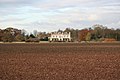
 Wiverton Hall - geograph.org.uk - 2255573.jpg 1,280 × 841; 404 KB
-
 Wiverton Hall parish - geograph.org.uk - 2255580.jpg 1,280 × 847; 659 KB
-


