Category:Winkel tripel projection
Jump to navigation
Jump to search
English: Winkel III is the well-done arithmetic mean of the equirectangular projection and the Aitoff projection.
It is one of the most-used projections: for example, it has been the standard reference map projection of the National Geographic Society since 1998).
English: This map-projection-related category exists in the following hierarchy:
- Category:Map projections
- Category:Maps by projection
- Category:Winkel tripel projection – media related to the Winkel tripel projection other than maps
- Category:Maps with Winkel tripel projection (“Category:Winkel tripel projections”) – maps made using the Winkel tripel projection
compromise map projection defined as the arithmetic mean of the equirectangular projection and the Aitoff projection  | |||||
| Upload media | |||||
| Instance of |
| ||||
|---|---|---|---|---|---|
| Discoverer or inventor |
| ||||
| |||||
Subcategories
This category has only the following subcategory.
W
Media in category "Winkel tripel projection"
The following 16 files are in this category, out of 16 total.
-
 Tissot indicatrix world map Winkel Tripel proj.svg 512 × 313; 827 KB
-
 Winkel triple projection SW.jpg 2,058 × 1,262; 733 KB
-
 Winkel Tripel Projection (Winkel III) (6959869955).png 2,058 × 1,262; 6.25 MB
-
 Winkel Tripel Projection (Winkel III) (6959946805).png 2,058 × 1,262; 5.63 MB
-
 World Map - city night lights (Winkel Tripel Projection - Americas).jpg 3,220 × 2,480; 1.45 MB
-
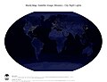
 World Map - city night lights (Winkel Tripel Projection - Pacific).jpg 3,220 × 2,480; 1.45 MB
-
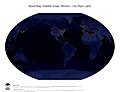
 World Map - city night lights (Winkel Tripel Projection).jpg 3,220 × 2,480; 1.44 MB
-
 World Map - city night lights and national borders (Winkel Tripel Projection - Americas).jpg 3,220 × 2,480; 1.59 MB
-
 World Map - city night lights and national borders (Winkel Tripel Projection - Pacific).jpg 3,220 × 2,480; 1.58 MB
-
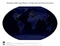 World Map - city night lights and national borders (Winkel Tripel Projection).jpg 3,220 × 2,480; 1.57 MB
-
 World Map - surface, bathymetry and topography (Winkel Tripel Projection - Americas).jpg 3,220 × 2,480; 2.46 MB
-
 World Map - surface, bathymetry and topography (Winkel Tripel Projection - Pacific).jpg 3,220 × 2,480; 2.45 MB
-
 World Map - surface, bathymetry and topography (Winkel Tripel Projection).jpg 3,220 × 2,480; 2.44 MB
-

-

-


_(6959869955).png)
_(6959946805).png)
.jpg)
.jpg)
.jpg)
.jpg)
.jpg)
.jpg)
.jpg)
.jpg)
.jpg)
.jpg)
.jpg)
.jpg)