Category:Windley
Jump to navigation
Jump to search
village and civil parish in Amber Valley district, Derbyshire, England  | |||||
| Upload media | |||||
| Pronunciation audio | |||||
|---|---|---|---|---|---|
| Instance of | |||||
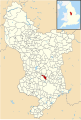
| Location | Amber Valley, Derbyshire, East Midlands, England | ||||
 | |||||
Media in category "Windley"
The following 93 files are in this category, out of 93 total.
-
 A country cottage - geograph.org.uk - 5822978.jpg 2,000 × 1,333; 2.77 MB
-
 A distant farm - geograph.org.uk - 5822939.jpg 2,000 × 1,333; 2.73 MB
-
 A lane near Windley Derbyshire.jpg 640 × 412; 178 KB
-
 A narrow country lane - geograph.org.uk - 5822950.jpg 2,000 × 1,333; 2.59 MB
-
 A new protected tree - geograph.org.uk - 5822973.jpg 2,000 × 1,333; 3.94 MB
-
 A weir in the stream - geograph.org.uk - 5237087.jpg 1,280 × 960; 640 KB
-
 Bridge over the River Ecclesbourne - geograph.org.uk - 2144425.jpg 640 × 480; 127 KB
-
 Champion Carr - geograph.org.uk - 5236977.jpg 1,280 × 960; 422 KB
-
 Champion Farm - geograph.org.uk - 2194822.jpg 3,648 × 2,736; 5.24 MB
-
 Derbyshire UK parish map highlighting Windley.svg 888 × 1,308; 2.34 MB
-
 Distant cattle - geograph.org.uk - 5822952.jpg 2,000 × 1,333; 3.24 MB
-
 Earthwork and Coppice near Ruined Hall - geograph.org.uk - 3942579.jpg 3,868 × 2,814; 1.72 MB
-

-
 Entrance Gates to Ruined Hall - geograph.org.uk - 3941340.jpg 3,794 × 2,700; 3.14 MB
-
 Farm at Cocks-hut Hill - geograph.org.uk - 2194846.jpg 3,648 × 2,736; 5.81 MB
-
 Farm bridge over the Ecclesbourne - geograph.org.uk - 5209846.jpg 1,280 × 960; 728 KB
-
 Farmland and hedgerows - geograph.org.uk - 3996864.jpg 640 × 480; 60 KB
-
 Farmland in Derbyshire - geograph.org.uk - 2144456.jpg 640 × 480; 77 KB
-
 Farmland off Wirksworth Road - geograph.org.uk - 3996034.jpg 640 × 480; 117 KB
-
 Farnah Lodge, with VR post box - geograph.org.uk - 2144465.jpg 640 × 480; 132 KB
-
 Field of Cattle near Gunhills Lane - geograph.org.uk - 3594509.jpg 4,000 × 3,000; 1.96 MB
-
 Footbridge over the River Ecclesbourne - geograph.org.uk - 4548484.jpg 1,024 × 615; 104 KB
-
 Footpath sign on Woodfall Lane - geograph.org.uk - 2194857.jpg 3,648 × 2,736; 5.59 MB
-
 Footpath to Duffield - geograph.org.uk - 3996043.jpg 640 × 462; 126 KB
-
 Ford on the path to Windleyhill Farm - geograph.org.uk - 5237025.jpg 1,280 × 960; 682 KB
-
 Grazing Land near Windley Meadows - geograph.org.uk - 3594183.jpg 4,000 × 3,000; 2.06 MB
-
 Grazing near Home Farm - geograph.org.uk - 4308988.jpg 4,000 × 3,000; 2.73 MB
-
 Grazing near Home Farm - geograph.org.uk - 4308993.jpg 4,000 × 3,000; 3.07 MB
-
 Harvesting at Cocks-hut-hill - geograph.org.uk - 5486129.jpg 1,280 × 960; 449 KB
-
 Hole Farm (2) - geograph.org.uk - 2144436.jpg 640 × 480; 66 KB
-
 Hole Farm - geograph.org.uk - 2144428.jpg 640 × 480; 52 KB
-
 House on Wirksworth Road, Windley - geograph.org.uk - 4548511.jpg 1,024 × 768; 106 KB
-
 Large Dwelling on Windley Lane - geograph.org.uk - 3595372.jpg 4,000 × 3,000; 2.25 MB
-
 Lift bar stile - geograph.org.uk - 5237015.jpg 1,280 × 960; 401 KB
-
 Lime kiln site - geograph.org.uk - 2300094.jpg 3,648 × 2,736; 5.99 MB
-
 Looking at the Ecclesbourne Valley - geograph.org.uk - 5822932.jpg 2,000 × 1,333; 3.1 MB
-
 Lower pond at Windley Hall - geograph.org.uk - 5716602.jpg 1,280 × 960; 609 KB
-
 Moat, in farmland near Duffield - geograph.org.uk - 2144460.jpg 640 × 480; 98 KB
-
 Modern white house in a rural setting - geograph.org.uk - 2299589.jpg 3,648 × 2,736; 5.7 MB
-
 Old Milepost by the B5023, Windley Meadows (geograph 5623810).jpg 997 × 1,468; 205 KB
-
 Old Milepost by the B5023, Wirksworth Road (geograph 5623811).jpg 997 × 1,468; 181 KB
-
 Path signpost and gate - geograph.org.uk - 2194833.jpg 3,648 × 2,736; 5.77 MB
-
 Path to Farnah Lodge - geograph.org.uk - 2144463.jpg 640 × 480; 115 KB
-
 Puss in Boots, Windley.jpg 4,899 × 3,545; 2.83 MB
-
 Ridge and furrow field at Champion Carr - geograph.org.uk - 5237001.jpg 1,280 × 960; 337 KB
-
 Rural Boozer in Windley - geograph.org.uk - 3594219.jpg 4,000 × 3,000; 2.59 MB
-
 Rural T Junction near Windley - geograph.org.uk - 3594498.jpg 3,950 × 2,932; 1.48 MB
-

-
 Signs at lane junction - geograph.org.uk - 2194867.jpg 3,648 × 2,736; 5.02 MB
-
 Spot the bus-stop - geograph.org.uk - 2299606.jpg 3,648 × 2,736; 6.11 MB
-
 Squeeze stile and signpost off Wirksworth Road - geograph.org.uk - 5716579.jpg 1,280 × 960; 546 KB
-
 Stile on the Ecclesbourne Way - geograph.org.uk - 5486160.jpg 1,280 × 960; 575 KB
-
 Stone bridge over a stream - geograph.org.uk - 5237055.jpg 1,280 × 960; 516 KB
-
 Stone Fence Post - geograph.org.uk - 291175.jpg 640 × 480; 130 KB
-

-
 The Centenary Way by Spring Carr - geograph.org.uk - 5237048.jpg 1,280 × 960; 495 KB
-
 The drying meadow - geograph.org.uk - 5822929.jpg 2,000 × 1,333; 3.01 MB
-
 The Ecclesbourne Way crossing Windley Brook - geograph.org.uk - 5486173.jpg 1,280 × 960; 748 KB
-
 The Forge - geograph.org.uk - 5209865.jpg 1,280 × 960; 303 KB
-
 The Puss in Boots pub - geograph.org.uk - 3996863.jpg 640 × 473; 56 KB
-
 The River Ecclesbourne - geograph.org.uk - 2144468.jpg 640 × 480; 112 KB
-
 The River Ecclesbourne near Windley - geograph.org.uk - 284975.jpg 640 × 429; 172 KB
-
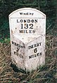
 The Windley milepost - detail - geograph.org.uk - 1703945.jpg 538 × 717; 205 KB
-
 The Windley milepost in its setting - geograph.org.uk - 1703939.jpg 922 × 691; 166 KB
-
 This is not a bus route - geograph.org.uk - 2144444.jpg 640 × 480; 75 KB
-
 Track and Footpath Towards Champion Farm - geograph.org.uk - 3941307.jpg 4,000 × 3,000; 2.39 MB
-
 Trees along a tributary of the Ecclesbourne - geograph.org.uk - 4548507.jpg 1,024 × 614; 124 KB
-
 Unnamed Valley at the Limekilns - geograph.org.uk - 4307891.jpg 4,000 × 3,000; 2.39 MB
-
 Upper pond at Windley Hall - geograph.org.uk - 5716608.jpg 1,280 × 960; 654 KB
-
 Weir on the River Ecclesbourne - geograph.org.uk - 3996856.jpg 640 × 480; 132 KB
-
 Wheatfield in the Ecclesbourne valley - geograph.org.uk - 4548504.jpg 1,024 × 614; 116 KB
-
 Windley - geograph.org.uk - 177404.jpg 640 × 480; 143 KB
-
 Windley Baptist Chapel - geograph.org.uk - 3595360.jpg 3,972 × 2,964; 2.05 MB
-
 Windley Baptist Chapel, Derbyshire.jpg 2,304 × 3,072; 1.81 MB
-
 Windley Brook - geograph.org.uk - 5486185.jpg 1,280 × 960; 559 KB
-
 Windley Hall - geograph.org.uk - 3594534.jpg 3,910 × 2,876; 1.81 MB
-
 Windley Meadows - geograph.org.uk - 3996045.jpg 640 × 480; 56 KB
-
 Windley MMB 01 Ecclesbourne Valley Railway 101XXX.jpg 3,411 × 2,202; 2.38 MB
-
Windley.ogg 2.2 s; 25 KB
-
 Windleyhill Farm - geograph.org.uk - 2144451.jpg 640 × 480; 91 KB
-
 Wirksworth Road (B5023) - geograph.org.uk - 3996037.jpg 640 × 480; 114 KB
-
 Wirksworth Road (B5023) - geograph.org.uk - 3996854.jpg 640 × 480; 62 KB
-
 Wirksworth Road (B5023) - geograph.org.uk - 3996865.jpg 640 × 480; 60 KB
-
 Wirksworth Road (B5023) - geograph.org.uk - 3996870.jpg 640 × 480; 106 KB
-
 Yew Tree Farmhouse - geograph.org.uk - 2144431.jpg 640 × 547; 90 KB
-
 Above The Clouds - geograph.org.uk - 180362.jpg 640 × 480; 96 KB
-
 Ecclesbourne Valley railway line - geograph.org.uk - 284963.jpg 640 × 429; 154 KB
-
 Entrance to Flower Lilies. - geograph.org.uk - 291178.jpg 640 × 480; 116 KB
-
 Gun Hills - geograph.org.uk - 180354.jpg 640 × 480; 90 KB
-
 Newlands Farm - geograph.org.uk - 180347.jpg 640 × 480; 128 KB
-
 Road Junction at Gun Hills - geograph.org.uk - 180350.jpg 640 × 480; 86 KB
-
 The Clouds Farm - geograph.org.uk - 180358.jpg 640 × 480; 92 KB
-
 The Well - geograph.org.uk - 291166.jpg 640 × 480; 126 KB


_-_geograph.org.uk_-_2144436.jpg)


.jpg)
.jpg)


_-_geograph.org.uk_-_3996037.jpg)
_-_geograph.org.uk_-_3996854.jpg)
_-_geograph.org.uk_-_3996865.jpg)
_-_geograph.org.uk_-_3996870.jpg)


