Category:Wimbachtal
Jump to navigation
Jump to search
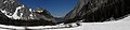
Deutsch: Das Wimbachtal, ein mehr als 10 km langes Hochtal in den Berchtesgadener Alpen im Landkreis Berchtesgadener Land.
valley in Ramsau bei Berchtesgaden, Germany  | |||||
| Upload media | |||||
| Instance of | |||||
|---|---|---|---|---|---|
| Location | Ramsau bei Berchtesgaden, Berchtesgadener Land, Upper Bavaria, Bavaria, Germany | ||||
| Width |
| ||||
| Length |
| ||||
| Area |
| ||||
| Elevation above sea level |
| ||||
| official website | |||||
 | |||||
Subcategories
This category has the following 3 subcategories, out of 3 total.
W
- Wimbachgrieshütte (5 F)
- Wimbachschloss (4 F)
Media in category "Wimbachtal"
The following 61 files are in this category, out of 61 total.
-
 20220824 Erosion am Grunde des Loferer Seilergrabens, Wimbachgries (02866).jpg 5,718 × 3,812; 16 MB
-
 20220824 Gams in namenloser Scharte im Loferer Seilergraben (02854).jpg 5,749 × 3,832; 7.92 MB
-
 20220824 Leergefegte Erosionsrinne im Loferer Seilergraben (02800).jpg 6,000 × 4,000; 20.08 MB
-
 Blick in den Nationalpark Berchtesgaden.jpg 7,073 × 4,000; 14.72 MB
-
 Brunftbergtiefe.jpg 2,560 × 1,920; 2.78 MB
-
 Canyon im Wimbachtal.JPG 1,536 × 2,048; 815 KB
-
 Carl Hasch Gebirgsbach in der Ramsau.jpg 2,732 × 2,046; 1.24 MB
-

-
-

-

-
 Geröllmassen.jpg 4,000 × 3,000; 4.51 MB
-
 Hochkalter und Wimbachtal.jpg 3,264 × 2,448; 648 KB
-
 Hochkalter vom Wimbachtal.jpg 4,176 × 2,784; 11.02 MB
-
 Hochkalter Wigries 2012.jpg 1,280 × 960; 438 KB
-
 Im Wimbachtal.JPG 4,288 × 2,848; 6.29 MB
-
 Kleines Palfelhorn Oktober 2017.jpg 4,000 × 2,667; 6.5 MB
-
 Koenigsseetour-08-Weg-1988-gje.jpg 2,717 × 1,803; 2.3 MB
-
 Koenigsseetour-10-verschuettete Bank-1988-gje.jpg 2,717 × 1,803; 3.03 MB
-
 Koenigsseetour-12-Weg-1988-gje.jpg 1,787 × 2,359; 2.2 MB
-
 Koenigsseetour-14-Wimbachtal-1988-gje.jpg 2,717 × 1,803; 2.43 MB
-
 Koenigsseetour-16-Azaleen-1988-gje.jpg 2,572 × 1,553; 2.26 MB
-
 Koenigsseetour-20-Farn und Glockenblume-1988-gje.jpg 1,788 × 2,255; 2.24 MB
-
 Koenigsseetour-22-Vergissmeinnicht-1988-gje.jpg 1,362 × 1,662; 647 KB
-
 Koenigsseetour-24-Akelei-1988-gje.jpg 1,482 × 1,039; 396 KB
-
 Koenigsseetour-26-rosa Teppich-1988-gje.jpg 2,717 × 1,803; 2.93 MB
-
 Koenigsseetour-28-Stein-1988-gje.jpg 1,784 × 2,470; 2.55 MB
-
 Mitterfleck, Wimbachtal.jpg 2,560 × 1,920; 2.7 MB
-
 Mitterfleck.jpg 2,560 × 1,920; 2.99 MB
-
 Nationalpark berchtesgaden blick ins obere wimbachtal ds wv 09 2012.jpg 1,200 × 951; 217 KB
-
 Nationalpark Berchtesgaden Wimbachgries Bergahorn hat nicht überlebt.jpg 5,184 × 3,456; 7.47 MB
-
 Nationalpark Berchtesgaden Wimbachgries Bergahorn.jpg 4,320 × 2,880; 3.17 MB
-
 Nationalpark Berchtesgaden Wimbachgries Bergahorn.tif 1,200 × 1,600; 5.51 MB
-
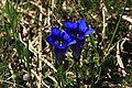 NP Berchtesgaden Wimbachgries Stengelloser Enzian.jpg 3,888 × 2,592; 2.84 MB
-
 Panorama wimbachtal.jpg 5,008 × 1,168; 2.69 MB
-
 Schuttfeld, Wimbachtal.jpg 4,000 × 3,000; 4.42 MB
-
 Schuttfeld.jpg 4,000 × 3,000; 4.37 MB
-
 Schuttflächen, Wimbachtal.jpg 2,560 × 1,920; 2.79 MB
-
 Schuttlandschaft, Wimbachtal.jpg 4,000 × 3,000; 4.53 MB
-
 Silberwurz, Wimbachtal.jpg 2,560 × 1,920; 1.66 MB
-
 Strudelloch Dachsteinkalk Wimbachtal.JPG 2,048 × 1,536; 2.09 MB
-
 Wimbach Gries.JPG 4,000 × 3,000; 5.72 MB
-
 Wimbach-Tal.jpg 4,000 × 3,000; 3.13 MB
-
 Wimbachgries 040704.jpg 768 × 1,024; 347 KB
-
 Wimbachgries 310802 (cropped).jpg 571 × 464; 93 KB
-
 Wimbachgries 310802.jpg 960 × 720; 290 KB
-
 Wimbachgries Schichtung im Schuttstrom.JPG 1,280 × 960; 478 KB
-
 Wimbachgries Sedimente.jpg 1,280 × 960; 483 KB
-

-
 Wimbachgries.jpg 4,032 × 3,024; 4.44 MB
-
 Wimbachklamm 01.JPG 4,864 × 1,264; 2.88 MB
-
 Wimbachklamm 6.JPG 2,592 × 3,888; 7.31 MB
-
 Wimbachtal - September 2015 - 1.jpg 2,720 × 1,817; 2.11 MB
-
 Wimbachtal - September 2015 - 2.jpg 3,000 × 2,180; 5.12 MB
-
 Wimbachtal - September 2015 - 3.jpg 2,680 × 2,010; 4.28 MB
-
 Wimbachtal - September 2015 - 4.jpg 2,867 × 2,190; 5.15 MB
-
 Wimbachtal bei Ramsau.jpg 4,000 × 3,000; 4.65 MB
-
 Wimbachtal oberere Sektion.jpg 3,000 × 4,000; 1.89 MB
-
 Wimbachtal Terrasse Felsdurchbruch.jpg 2,048 × 1,536; 3.04 MB
-
 Wimbachtal, Ramsau.jpg 4,000 × 3,000; 4.66 MB
-
 Wimbachtal.jpg 1,536 × 1,024; 295 KB
.jpg)
.jpg)
.jpg)


.jpg)


