Category:Willibrorduskerk (Boskamp)
Jump to navigation
Jump to search
| Object location | | View all coordinates using: OpenStreetMap |
|---|
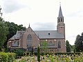
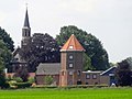
church building in Olst-Wijhe, Netherlands  | |||||
| Upload media | |||||
| Instance of | |||||
|---|---|---|---|---|---|
| Part of | |||||
| Location | Olst, Overijssel, Netherlands | ||||
| Street address |
| ||||
| Architect | |||||
| Heritage designation |
| ||||
| Inception |
| ||||
| Significant event |
| ||||
| Religion or worldview | |||||
 | |||||
Nederlands: Willibrorduskerk - anno 1860
|
This is a category about rijksmonument number 508567
|
| Address |
|
Media in category "Willibrorduskerk (Boskamp)"
The following 6 files are in this category, out of 6 total.
-
 20150706 Willibrorduskerk Boskamp.jpg 4,896 × 3,672; 1.45 MB
-
 20150706 Zicht op Boskamp met Willibrorduskerk vanuit het noorden.jpg 4,896 × 3,672; 1,002 KB
-
 20150706 Zicht op Boskamp met Willibrorduskerk vanuit het oosten.jpg 4,896 × 2,483; 594 KB
-
 20150706 Zicht op Boskamp2 met Willibrorduskerk vanuit het oosten.jpg 2,706 × 2,030; 2.81 MB
-
 Boskamp Willibrordus Kerk.JPG 4,000 × 3,000; 4.75 MB
-
 Interieur, aanzicht orgel, orgelnummer 210 - Boskamp - 20349127 - RCE.jpg 808 × 1,200; 143 KB


