Category:Wilberfoss
Jump to navigation
Jump to search
English: Wilberfoss is a village and civil parish in the East Riding of Yorkshire, England. It is situated on the north side of the A1079 approximately 8 miles (13 km) east of York city centre and 11 miles (18 km) north west of Market Weighton.
village in the United Kingdom  | |||||
| Upload media | |||||
| Instance of | |||||
|---|---|---|---|---|---|
| Location | East Riding of Yorkshire, Yorkshire and the Humber, England | ||||
| Population |
| ||||
 | |||||
Subcategories
This category has the following 4 subcategories, out of 4 total.
Media in category "Wilberfoss"
The following 200 files are in this category, out of 212 total.
(previous page) (next page)-
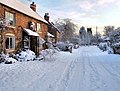
 1991 Winter In Wilberfoss - geograph.org.uk - 1264833.jpg 640 × 512; 104 KB
-
 1991 Winter In Wilberfoss - geograph.org.uk - 1264845.jpg 640 × 494; 106 KB
-
 2010 Wilberfoss Birker Lane Field Head Junction - geograph.org.uk - 1726273.jpg 1,744 × 1,308; 856 KB
-
 A path heading to High Catton (geograph 3131119).jpg 800 × 600; 239 KB
-
 A walk from Wilberfoss ^1 - geograph.org.uk - 2003310.jpg 800 × 600; 248 KB
-
 A walk from Wilberfoss ^2 - geograph.org.uk - 2003315.jpg 800 × 600; 262 KB
-
 A walk from Wilberfoss ^3 - geograph.org.uk - 2003318.jpg 800 × 600; 334 KB
-
 A walk from Wilberfoss ^4 - geograph.org.uk - 2003325.jpg 800 × 600; 313 KB
-
 A1079 at power lines east of Wilberfoss (geograph 6824618).jpg 1,024 × 723; 184 KB
-
 A1079 at Wilberfoss (geograph 6824617).jpg 1,024 × 726; 174 KB
-
 Access road from Foss Farm toward Birker Lane (geograph 4878335).jpg 4,608 × 3,456; 3.33 MB
-
 Across to Wilberfoss Church - geograph.org.uk - 399332.jpg 640 × 478; 112 KB
-
 Another field going for housing (geograph 4881133).jpg 4,608 × 3,456; 5.84 MB
-
 Autumn Around The Beck - geograph.org.uk - 1574627.jpg 640 × 480; 374 KB
-
 Autumn in Wilberfoss - geograph.org.uk - 1574636.jpg 640 × 480; 278 KB
-
 Beck near Fangfoss (geograph 5415044).jpg 515 × 640; 528 KB
-
 Beckside to Birker Lane - geograph.org.uk - 737463.jpg 1,744 × 1,308; 1.72 MB
-
 Beckside Wilberfoss - geograph.org.uk - 1610408.jpg 640 × 480; 119 KB
-
 Beckside Wilberfoss - geograph.org.uk - 1610471.jpg 640 × 480; 73 KB
-
 Beckside, Wilberfoss (geograph 5739364).jpg 1,024 × 768; 249 KB
-
 Behind Field Head - geograph.org.uk - 737412.jpg 1,744 × 1,308; 1.48 MB
-
 Birker Lane (geograph 6494456).jpg 1,024 × 768; 223 KB
-
-
 Blossom In Middle Street - geograph.org.uk - 725868.jpg 1,660 × 1,308; 2.21 MB
-
 Blossom on Foss Beck side - geograph.org.uk - 723631.jpg 1,744 × 1,308; 2.14 MB
-
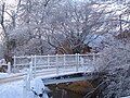
 Bridge over the beck - geograph.org.uk - 399301.jpg 478 × 640; 166 KB
-
 Butcher Bridge and Foot Bridge June 2007 - geograph.org.uk - 722280.jpg 1,737 × 1,308; 2.24 MB
-
 Butchers, Main Street, Wilberfoss - geograph.org.uk - 2371527.jpg 1,508 × 1,600; 408 KB
-
 Butterbur growing by the Foss Beck (geograph 5739349).jpg 1,024 × 768; 446 KB
-
 Children's Nursery, Storking Lane, Wilberfoss - geograph.org.uk - 2371507.jpg 1,600 × 1,200; 360 KB
-
 Church and beck - geograph.org.uk - 399316.jpg 640 × 478; 155 KB
-
 Church and Middle Street - geograph.org.uk - 399308.jpg 640 × 478; 148 KB
-
 Common Beck - geograph.org.uk - 399283.jpg 478 × 640; 138 KB
-
 Cottages, Middle Street, Wilberfoss (geograph 5739240).jpg 1,024 × 768; 244 KB
-
 Crossroads - geograph.org.uk - 399396.jpg 640 × 478; 139 KB
-
 Down the hill. - geograph.org.uk - 399331.jpg 478 × 640; 143 KB
-
 Drilling Corn - geograph.org.uk - 737673.jpg 1,744 × 1,308; 1.2 MB
-
 Entering Wilberfoss - geograph.org.uk - 399279.jpg 640 × 478; 123 KB
-
 Entrance to a poultry unit, Bolton Lane (geograph 5738096).jpg 1,024 × 768; 229 KB
-
 Entrance to Willow Farm (geograph 5717626).jpg 1,600 × 1,200; 711 KB
-
 Farm building - geograph.org.uk - 399293.jpg 640 × 478; 160 KB
-
 Farmers Road behind Field Head Looking North - geograph.org.uk - 725806.jpg 1,744 × 1,308; 1.84 MB
-

-
 Farmland near Carberry Hall Farm - geograph.org.uk - 1846204.jpg 640 × 480; 64 KB
-
 Farmland near Carberry Hall Farm - geograph.org.uk - 1846216.jpg 640 × 480; 58 KB
-
 Farmland off Sand Lane - geograph.org.uk - 1846151.jpg 640 × 480; 68 KB
-
 Field Head Facing South - geograph.org.uk - 725812.jpg 640 × 480; 63 KB
-
 Field on West Moor (geograph 6447885).jpg 1,024 × 683; 535 KB
-
 Flood Casualties - geograph.org.uk - 722710.jpg 1,737 × 1,308; 2.49 MB
-
 Flood Victims June 2007 - geograph.org.uk - 722757.jpg 1,737 × 1,308; 2.71 MB
-
 Floods June 2007 - geograph.org.uk - 722723.jpg 1,737 × 1,308; 2.25 MB
-
 Floods June 2007 - geograph.org.uk - 722743.jpg 1,737 × 1,308; 2.4 MB
-
 Footpath between Ings Lane and Middle Street, Wilberfoss (geograph 5739239).jpg 1,024 × 768; 157 KB
-
 Footpath between Main Street and Back Lane, Wilberfoss (geograph 5739153).jpg 1,024 × 737; 223 KB
-
 Footpath From Field Head towards Carberry Hall Farm - geograph.org.uk - 722997.jpg 1,280 × 960; 1.35 MB
-
 Footpath from Wilberfoss toward Carberry Hill Farm (geograph 4878339).jpg 4,608 × 3,456; 3.96 MB
-
 Footpath to Wilberfoss (geograph 4881182).jpg 4,608 × 3,456; 4.37 MB
-
 Foss Beck - geograph.org.uk - 211203.jpg 640 × 479; 55 KB
-
 Foss Beck In March - geograph.org.uk - 723640.jpg 1,744 × 1,308; 2.21 MB
-
 Foss Beck running through Wilberfoss (geograph 4881104).jpg 3,456 × 4,608; 5.45 MB
-
 Foss Beck, Wilberfoss (geograph 6494459).jpg 1,024 × 768; 258 KB
-
 Foss Farm - geograph.org.uk - 1733943.jpg 3,488 × 2,616; 4.6 MB
-
 From Birker Lane to St Oswald's Close - geograph.org.uk - 722970.jpg 1,744 × 1,308; 1.44 MB
-
 From Bolton Lane - geograph.org.uk - 399399.jpg 640 × 478; 147 KB
-
 Frost Butchers, Main Street, Wilberfoss (geograph 5739163).jpg 1,024 × 768; 160 KB
-
 Frosty Pylon at Wilberfoss - geograph.org.uk - 1726216.jpg 1,744 × 1,308; 847 KB
-
 Gaggle of geese, a peacock and a cattery - geograph.org.uk - 399409.jpg 640 × 478; 186 KB
-
 Grassed area, Storking Lane, Wilberfoss (geograph 5739219).jpg 1,024 × 768; 323 KB
-
 Hail Stones At The End Of Birker Lane - geograph.org.uk - 723678.jpg 1,744 × 1,308; 2.35 MB
-
 Harvested corn in Wilberfoss - geograph.org.uk - 211192.jpg 640 × 479; 57 KB
-
 Hedgerow in April 2007 - geograph.org.uk - 723911.jpg 1,744 × 1,308; 2.57 MB
-
 Heron Leaving Dyke - geograph.org.uk - 1740982.jpg 2,180 × 1,473; 2.28 MB
-
 High Catton to Wilberfoss Footpath - geograph.org.uk - 436456.jpg 640 × 469; 92 KB
-
 Ings Road Storking Lane Junction - geograph.org.uk - 738814.jpg 1,744 × 1,308; 1.5 MB
-
 Junction on the right Carr Lane to Yapham (geograph 5274527).jpg 3,789 × 2,813; 2.25 MB
-
 Kiddies Corner Day Nursery, Wilberfoss (geograph 5739232).jpg 1,024 × 677; 116 KB
-
 Lane to nowhere - geograph.org.uk - 399323.jpg 478 × 640; 172 KB
-
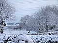
 Late Afternoon Snow Scene Wilberfoss - geograph.org.uk - 1726365.jpg 1,744 × 1,130; 972 KB
-
 Ling Lane (geograph 6877815).jpg 1,024 × 683; 337 KB
-
 Ling Lane towards Wilberfoss - geograph.org.uk - 2371497.jpg 1,600 × 1,200; 442 KB
-
 Long, straight and flat road. - geograph.org.uk - 107826.jpg 640 × 480; 93 KB
-
 Looking north along Newbridge Lane (geograph 3131009).jpg 800 × 600; 236 KB
-
 Looking Towards The Moat From Church Bridge - geograph.org.uk - 723615.jpg 1,744 × 1,308; 2.06 MB
-
 Main Street - From Shops Facing West - geograph.org.uk - 725886.jpg 1,744 × 1,287; 1.62 MB
-
 Main Street junction from Slip Road Over Butcher Bridge - geograph.org.uk - 723840.jpg 1,744 × 1,308; 2.14 MB
-
 Main Street Storking Lane Junction - geograph.org.uk - 725874.jpg 1,642 × 1,308; 2 MB
-
 Main Street, Wilberfoss (geograph 5413946).jpg 640 × 499; 556 KB
-
 Middle Street - geograph.org.uk - 399297.jpg 640 × 478; 157 KB
-
 Milestone - geograph.org.uk - 399328.jpg 640 × 478; 216 KB
-
 Mill Farm at the top of the field (geograph 4881160).jpg 4,608 × 3,456; 3.93 MB
-
 Mill Lane near Mill Farm (geograph 6494390).jpg 1,024 × 768; 180 KB
-
 Mill Lane, Wilberfoss (geograph 6494383).jpg 1,024 × 768; 217 KB
-
 Minor road junction on A1079 (geograph 5274542).jpg 3,532 × 2,408; 2.6 MB
-
 Moon and pylons (geograph 6877814).jpg 1,024 × 683; 350 KB
-
-
 New Bridge Lane - geograph.org.uk - 211226.jpg 640 × 479; 64 KB
-
 Newbridge Lane (geograph 3766470).jpg 427 × 640; 112 KB
-
 Newbridge Lane (geograph 5067797).jpg 640 × 427; 107 KB
-
 Newbridge Lane (geograph 5738102).jpg 1,024 × 745; 259 KB
-
 Newbridge Lane (geograph 6552445).jpg 1,024 × 768; 185 KB
-

-
 Old Green Lane (geograph 6552465).jpg 1,024 × 768; 210 KB
-
 Old line of road east of Wilberfoss (geograph 5717624).jpg 1,600 × 1,200; 1,008 KB
-
 Old Milestone by Windmill Hill, Wilberfoss (geograph 6048845).jpg 640 × 480; 320 KB
-
 On field track toward Carberry Hall Farm (geograph 4878325).jpg 4,608 × 3,456; 3.48 MB
-
 On the High Catton to Wilberfoss Footpath - geograph.org.uk - 436450.jpg 640 × 480; 122 KB
-
 Opposite Bolton Hall - geograph.org.uk - 211224.jpg 640 × 479; 44 KB
-
 Opposite Bolton Hall - geograph.org.uk - 399394.jpg 640 × 478; 111 KB
-
 Outskirts of Wilberfoss - geograph.org.uk - 399274.jpg 640 × 478; 156 KB
-
 Over Far Field to Red House Farm (geograph 4878331).jpg 4,608 × 3,456; 3.84 MB
-
 Owl at Wilberfoss - geograph.org.uk - 737802.jpg 640 × 549; 102 KB
-
 Pig Farm - geograph.org.uk - 399322.jpg 640 × 478; 147 KB
-
 Pig Farming and Dog Walking Birker Lane - geograph.org.uk - 725844.jpg 640 × 377; 106 KB
-
 Pigs are Back at Wilberfoss - geograph.org.uk - 1726768.jpg 3,664 × 2,748; 3.36 MB
-
 Pigs in dust - geograph.org.uk - 399320.jpg 640 × 478; 125 KB
-
 Post Office, Main Street, Wilberfoss - geograph.org.uk - 2371521.jpg 1,600 × 1,111; 379 KB
-
 Postbox on Bolton Lane at South Lodge (geograph 6560545).jpg 1,600 × 1,065; 749 KB
-
 Power Lines - geograph.org.uk - 107819.jpg 640 × 480; 66 KB
-
 Power lines near Wilberfoss (geograph 5413771).jpg 493 × 640; 305 KB
-
 Pylon at Wilberfoss - geograph.org.uk - 1741009.jpg 3,488 × 2,616; 4.38 MB
-
 Red House Farm - geograph.org.uk - 211211.jpg 640 × 479; 45 KB
-
 Road safety lesson in Wilberfoss (geograph 3137644).jpg 800 × 600; 338 KB
-
 Road to many farms - geograph.org.uk - 399401.jpg 640 × 478; 187 KB
-
 Sand Lane near Carr Tongue (geograph 5342132).jpg 4,000 × 3,000; 4.96 MB
-
 Sand Lane near Wilberfoss - geograph.org.uk - 1049604.jpg 640 × 480; 114 KB
-
 Sand Lane towards Yapham Common - geograph.org.uk - 1846153.jpg 640 × 480; 78 KB
-
 Sand Lane towards Yapham Common - geograph.org.uk - 1846162.jpg 640 × 480; 145 KB
-
 Sand Lane, Yapham Common (geograph 5746005).jpg 549 × 640; 190 KB
-
 Shops in Wilberfoss - geograph.org.uk - 399289.jpg 640 × 478; 135 KB
-
 Small bridge over the drain on Bolton Lane (geograph 6552458).jpg 1,024 × 768; 278 KB
-
 Snow at Field Head - geograph.org.uk - 722778.jpg 1,744 × 1,308; 1.44 MB
-
 Snow at Wilberfoss - geograph.org.uk - 737621.jpg 640 × 338; 87 KB
-
 Snow Returns To Wilberfoss - geograph.org.uk - 1726198.jpg 1,744 × 1,308; 1.06 MB
-
 Snowscene at Wilberfoss - geograph.org.uk - 1726303.jpg 1,744 × 1,308; 1.23 MB
-
 Snowy Birker Lane Wilberfoss - geograph.org.uk - 1726226.jpg 1,744 × 1,308; 1.03 MB
-
 Snowy Hedge at Wilberfoss - geograph.org.uk - 1726354.jpg 1,744 × 1,308; 1.37 MB
-
 Snowy Scene Wilberfoss - geograph.org.uk - 1726310.jpg 1,744 × 1,308; 852 KB
-
 Snowy Scene Wilberfoss - geograph.org.uk - 1726317.jpg 1,744 × 1,308; 1.08 MB
-
 Snowy Sunset at Wilberfoss - geograph.org.uk - 1726256.jpg 1,744 × 1,308; 675 KB
-
 Snowy Wilberfoss - geograph.org.uk - 1726336.jpg 1,744 × 1,308; 1.03 MB
-
 South Lodge (geograph 5740819).jpg 1,024 × 768; 180 KB
-
 Spittal Beck - geograph.org.uk - 1846218.jpg 640 × 480; 122 KB
-
 St Oswalds Close Wilberfoss - geograph.org.uk - 738804.jpg 1,744 × 1,308; 1.49 MB
-
 Stonebridge Drive Wilberfoss - geograph.org.uk - 1610416.jpg 640 × 480; 79 KB
-
 Stonebridge Drive Wilberfoss - geograph.org.uk - 1610433.jpg 640 × 480; 72 KB
-
 Stonebridge Drive Wilberfoss - geograph.org.uk - 1610441.jpg 640 × 480; 90 KB
-
 Stonebridge Drive Wilberfoss - geograph.org.uk - 1610459.jpg 640 × 480; 83 KB
-
 Storking Lane (geograph 6447887).jpg 1,024 × 683; 483 KB
-
 Storking Lane Passing Hawthorn Drive and Park Lane - geograph.org.uk - 738820.jpg 1,744 × 1,308; 1.72 MB
-
 Storking Lane, Wilberfoss - geograph.org.uk - 2371513.jpg 1,600 × 1,200; 433 KB
-
 Storking Lane, Wilberfoss - geograph.org.uk - 399285.jpg 640 × 478; 145 KB
-
 Sunset to The West - geograph.org.uk - 725824.jpg 1,744 × 1,257; 1.14 MB
-
 The A1079 passing to the south of Wilberfoss (geograph 3166305).jpg 2,560 × 1,920; 2 MB
-
 The A1079 passing Wilberfoss toward Kexby Bridge (geograph 5274985).jpg 2,969 × 2,160; 1.95 MB
-
 The beck - geograph.org.uk - 399314.jpg 640 × 478; 140 KB
-
 The Beck Behind Field Head - geograph.org.uk - 722691.jpg 1,737 × 1,308; 2.6 MB
-
 The Corn Is Sown - geograph.org.uk - 737686.jpg 1,744 × 1,308; 1.2 MB
-
 The Firs Cattery on Sands Lane (geograph 3130974).jpg 800 × 600; 356 KB
-

-
 The Foss Beck, Wilberfoss (geograph 5739357).jpg 1,024 × 768; 255 KB
-
 The Oddfellows Arms, Wilberfoss (geograph 3131106).jpg 800 × 600; 250 KB
-
 The Oddfellows Arms, Wilberfoss (geograph 3131112).jpg 600 × 800; 238 KB
-
 The Old School, Wilberfoss (geograph 3131116).jpg 800 × 600; 361 KB
-
 The Old School, Wilberfoss (geograph 5739207).jpg 1,024 × 721; 183 KB
-
 The Road to York (A1079) - geograph.org.uk - 107821.jpg 640 × 480; 83 KB
-

-
-
 The Village Inn - geograph.org.uk - 399290.jpg 640 × 478; 125 KB
-
 The Village Inn, Wilberfoss - geograph.org.uk - 2371576.jpg 1,600 × 1,200; 430 KB
-
 Through The Snowy Hedge - geograph.org.uk - 1726252.jpg 1,744 × 1,308; 975 KB
-
 Towards Wilberfoss - geograph.org.uk - 211197.jpg 640 × 479; 68 KB
-
 Towards York - geograph.org.uk - 399325.jpg 640 × 478; 136 KB
-
 Track on Far Field (geograph 6494450).jpg 1,024 × 768; 215 KB
-
 Track to Bolton Hall Farm - geograph.org.uk - 1846195.jpg 640 × 480; 149 KB
-
 Track to Carberry Hall Farm - geograph.org.uk - 1846210.jpg 640 × 480; 58 KB
-
 Trailer and bales - geograph.org.uk - 399400.jpg 640 × 478; 144 KB
-
 Travellers Pause on A1079 - geograph.org.uk - 725862.jpg 1,737 × 1,308; 2.22 MB
-
 Turf Cutting at Carberry Hall Farm - geograph.org.uk - 735274.jpg 1,280 × 960; 1.05 MB
-
 Up the beck - geograph.org.uk - 399305.jpg 640 × 478; 157 KB
-
 View towards Wilberfoss (geograph 5640474).jpg 1,024 × 768; 149 KB
-
 Village green and beck, Wilberfoss.jpg 640 × 478; 168 KB
-
 War Memorial, Wilberfoss - geograph.org.uk - 2371580.jpg 1,200 × 1,600; 523 KB
-
 Water Board Dyke Leading to Foss Beck - geograph.org.uk - 1733950.jpg 3,488 × 2,616; 4.48 MB
-
 Waterlogged field near Sails Bridge (geograph 5738094).jpg 1,024 × 768; 187 KB
-
 West Farm - geograph.org.uk - 399403.jpg 640 × 478; 114 KB
-
 Wilberfoss Allotments 2010 - geograph.org.uk - 1733959.jpg 3,488 × 2,616; 4.56 MB
-
 Wilberfoss and moat field - aerial 2015 (geograph 4609876).jpg 640 × 427; 89 KB
-

-
 Wilberfoss East Entrance - geograph.org.uk - 1726866.jpg 1,832 × 1,374; 2.63 MB
-
 Wilberfoss In Bloom - geograph.org.uk - 746451.jpg 640 × 480; 109 KB
-
 Wilberfoss In Bloom 2009 - geograph.org.uk - 1253333.jpg 640 × 480; 139 KB
-
 Wilberfoss in the snow - geograph.org.uk - 1726687.jpg 800 × 609; 307 KB
-
 Wilberfoss Main Street (geograph 4881113).jpg 4,608 × 3,456; 3.49 MB
-
 Wilberfoss to Yorkshire Wolds - geograph.org.uk - 1726246.jpg 1,744 × 1,308; 1.16 MB
-
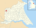 Wilberfoss UK parish locator map.svg 1,425 × 1,107; 1.68 MB
-
 Wilberfoss Winter - geograph.org.uk - 1625560.jpg 640 × 480; 404 KB
-
 Wilberfoss Winter - geograph.org.uk - 1625634.jpg 640 × 480; 302 KB
-
 Wilberfoss Winter - geograph.org.uk - 1625647.jpg 640 × 480; 254 KB
-
 Wilberfoss Winter - geograph.org.uk - 1726711.jpg 1,744 × 1,308; 1.09 MB
-
 Wilberfoss Winter - geograph.org.uk - 1726722.jpg 1,744 × 1,308; 972 KB


.jpg)


.jpg)
.jpg)
.jpg)

.jpg)


.jpg)


.jpg)

.jpg)


.jpg)


.jpg)


.jpg)
.jpg)


.jpg)


.jpg)
.jpg)

.jpg)
.jpg)


.jpg)
.jpg)


.jpg)


.jpg)


.jpg)
.jpg)


.jpg)


.jpg)


.jpg)


.jpg)
.jpg)
.jpg)
.jpg)
.jpg)


.jpg)
.jpg)
.jpg)
.jpg)

.jpg)
.jpg)
.jpg)
.jpg)


.jpg)


.jpg)

.jpg)


.jpg)

.jpg)


.jpg)

.jpg)


.jpg)


.jpg)


.jpg)
.jpg)


.jpg)

.jpg)
.jpg)
.jpg)
.jpg)
.jpg)
_-_geograph.org.uk_-_107821.jpg)
.jpg)
.jpg)


.jpg)


.jpg)


.jpg)


.jpg)
_Primary_School_(geograph_5738066).jpg)


.jpg)


