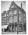
Category:Wijnhaven 16, Delft
Jump to navigation
Jump to search
| Object location | | View all coordinates using: OpenStreetMap |
|---|
house in Delft, Netherlands  | |||||
| Upload media | |||||
| Instance of | |||||
|---|---|---|---|---|---|
| Location | Delft, South Holland, Netherlands | ||||
| Street address |
| ||||
| Located on street | |||||
| Owned by |
| ||||
| Heritage designation |
| ||||
| Inception |
| ||||
 | |||||
|
This is a category about rijksmonument number 12264
|
| Address |
|
Media in category "Wijnhaven 16, Delft"
The following 23 files are in this category, out of 23 total.
-
 Aanzicht - Delft - 20053239 - RCE.jpg 958 × 1,200; 163 KB
-
 Bovengevel detail overkraging - Delft - 20336035 - RCE.jpg 1,200 × 1,197; 349 KB
-
 Drie voorgevels - Delft - 20325621 - RCE.jpg 938 × 1,200; 171 KB
-
 Gevels - Delft - 20053232 - RCE.jpg 1,055 × 1,200; 247 KB
-
 Hoek Boterbrug, sleutelstuk in slagerij - Delft - 20053247 - RCE.jpg 984 × 1,200; 140 KB
-
 InZicht Delft 142.JPG 3,648 × 2,598; 1.4 MB
-
 InZicht Delft 143.JPG 3,648 × 2,598; 1.38 MB
-
 Onderpui - Delft - 20053243 - RCE.jpg 1,200 × 962; 239 KB
-
 Onderpui hardsteen met getordeerde zuilen en traceerwerk - Delft - 20336032 - RCE.jpg 1,200 × 1,197; 323 KB
-
 Onderpui van de voorgevel - Delft - 20384416 - RCE.jpg 1,200 × 1,195; 274 KB
-
 Onderpui, detail ankers - Delft - 20336034 - RCE.jpg 1,200 × 1,197; 285 KB
-
 Onderpui, detail traceerwerk - Delft - 20336033 - RCE.jpg 1,197 × 1,200; 293 KB
-

-
 Overzicht van de voorgevels - Delft - 20384414 - RCE.jpg 1,200 × 1,186; 308 KB
-
 Tegel met voorbeeld - Delft - 20053245 - RCE.jpg 893 × 1,200; 258 KB
-
 Tegel met voorbeeld - Delft - 20053246 - RCE.jpg 890 × 1,200; 226 KB
-
 Voor- en zijgevel - Delft - 20053244 - RCE.jpg 944 × 1,200; 226 KB
-
 Voor- en zijgevel van het Gulden Tonneke te Delft - Delft - 20336029 - RCE.jpg 954 × 1,200; 240 KB
-
 Voorgevel - Delft - 20053242 - RCE.jpg 936 × 1,200; 168 KB
-
 Voorgevel - Delft - 20336030 - RCE.jpg 953 × 1,200; 210 KB
-
 Wijnhaven 16.jpg 1,944 × 2,592; 2.09 MB
-

-


