Category:Wijk 5 126, Urk
Jump to navigation
Jump to search
| Object location | | View all coordinates using: OpenStreetMap |
|---|
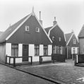
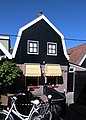
building in Urk, Netherlands  | |||||
| Upload media | |||||
| Instance of | |||||
|---|---|---|---|---|---|
| Location | Urk, Flevoland, Netherlands | ||||
| Street address |
| ||||
| Located on street |
| ||||
| Heritage designation |
| ||||
 | |||||
|
This is a category about rijksmonument number 35905
|
| Address |
|
Media in category "Wijk 5 126, Urk"
The following 4 files are in this category, out of 4 total.
-
 Gevel - Urk - 20211701 - RCE.jpg 1,190 × 1,200; 233 KB
-
 Gevels - Urk - 20211703 - RCE.jpg 1,195 × 1,200; 238 KB
-
 Urk - Wijk 5-126 RM35905.JPG 3,231 × 4,512; 2.88 MB
-
 Voorgevel - Urk - 20211700 - RCE.jpg 1,194 × 1,200; 232 KB


