Category:Wierda Bridge
Jump to navigation
Jump to search
| Object location | | View all coordinates using: OpenStreetMap |
|---|
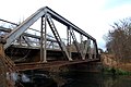
| This category shows a South African Protected Site with SAHRA file reference 9/2/258/0162 See also: External entry in South African Heritage Resource Agency database. |
Media in category "Wierda Bridge"
The following 2 files are in this category, out of 2 total.
-
 Wierda Bridge wide.JPG 2,836 × 1,819; 2.43 MB
-
 Wierda Bridge.JPG 3,008 × 2,000; 2.7 MB

