Category:Wide Area Augmentation System
Jump to navigation
Jump to search
system that enhances the accuracy of GPS receivers | |||||
| Upload media | |||||
| Instance of | |||||
|---|---|---|---|---|---|
| Location |
| ||||
| Operator | |||||
| Inception |
| ||||
| |||||
Media in category "Wide Area Augmentation System"
The following 14 files are in this category, out of 14 total.
-
 BFI Runway.jpg 4,032 × 3,024; 2.09 MB
-
 FAA WAAS coverage late 2006.jpg 400 × 202; 40 KB
-
 FAA WAAS coverage next generation.jpg 446 × 244; 40 KB
-
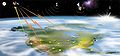
 FAA WAAS System Overview.jpg 800 × 535; 71 KB
-
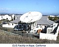 Napa GUS facility.jpg 353 × 283; 26 KB
-
 New Paradigm WAAS.png 481 × 484; 19 KB
-
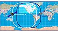
 WAAS GEO Footprint March 2010.jpg 687 × 379; 94 KB
-
 WAAS Reference Station Barrow Alaska.jpg 352 × 249; 12 KB
-
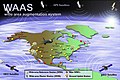
 WAAS service area.png 1,200 × 900; 63 KB
-
 Waas-GlobeLogo with text.png 1,004 × 866; 87 KB
-
 WAAS-Logo.gif 150 × 65; 2 KB
-
 Waas-logo.svg 512 × 222; 2 KB
-
 Waas.jpg 400 × 185; 10 KB
-
 Waas.png 420 × 302; 21 KB


