Category:White Mill Bridge, Sturminster Marshall
Jump to navigation
Jump to search
| Object location | | View all coordinates using: OpenStreetMap |
|---|
Grade I listed bridge in East Dorset, England, UK  | |||||
| Upload media | |||||
| Instance of | |||||
|---|---|---|---|---|---|
| Made from material | |||||
| Location | Shapwick, Dorset, South West England, England | ||||
| Crosses | |||||
| Heritage designation |
| ||||
| Inception |
| ||||
 | |||||
Media in category "White Mill Bridge, Sturminster Marshall"
The following 16 files are in this category, out of 16 total.
-
 Bridge over the Stour at White Mill - Floodtime - panoramio.jpg 4,648 × 2,743; 4.03 MB
-
 Jan 2014, flooding at White Mill Bridge - geograph.org.uk - 3800733.jpg 640 × 427; 329 KB
-
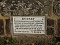
 Sign, White Mill Bridge - geograph.org.uk - 2434854.jpg 640 × 481; 93 KB
-
-

-
 White Mill Bridge (2) - geograph.org.uk - 600530.jpg 640 × 427; 164 KB
-
 White Mill Bridge - geograph.org.uk - 2487553.jpg 1,024 × 768; 203 KB
-
 White Mill Bridge - geograph.org.uk - 3082342.jpg 1,000 × 750; 491 KB
-
 White Mill Bridge - geograph.org.uk - 5639779.jpg 1,600 × 1,069; 451 KB
-
 White Mill Bridge - geograph.org.uk - 600169.jpg 640 × 427; 163 KB
-
 White Mill bridge at Sturminster Marshall - geograph.org.uk - 2890892.jpg 2,048 × 1,536; 2.45 MB
-
 White Mill Bridge near Sturminster Marshall - geograph.org.uk - 4274735.jpg 1,024 × 768; 245 KB
-
 White Mill Bridge, Sturminster Marshall (geograph 2018877).jpg 640 × 481; 101 KB
-
 White Mill Bridge, Sturminster Marshall - geograph.org.uk - 1751933.jpg 3,008 × 2,000; 2.4 MB
-
 White Mill Bridge, Sturminster Marshall - geograph.org.uk - 1751935.jpg 3,008 × 2,000; 2.39 MB
-
 White Mill Bridge, Sturminster Marshall.jpg 6,016 × 4,000; 9.29 MB


_-_geograph.org.uk_-_600530.jpg)


.jpg)

