Category:Westhaven 19, Gouda
Jump to navigation
Jump to search
| Object location | | View all coordinates using: OpenStreetMap |
|---|
house in Gouda, Netherlands  | |||||
| Upload media | |||||
| Instance of | |||||
|---|---|---|---|---|---|
| Location | Gouda, South Holland, Netherlands | ||||
| Street address |
| ||||
| Located on street | |||||
| Heritage designation |
| ||||
 | |||||
|
This is a category about rijksmonument number 16965
|
| Address |
|
Media in category "Westhaven 19, Gouda"
The following 8 files are in this category, out of 8 total.
-
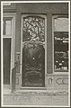
 Deur - Gouda - 20082976 - RCE.jpg 892 × 1,200; 205 KB
-
 Gevels - Gouda - 20082975 - RCE.jpg 804 × 1,200; 164 KB
-
 Ingang - Gouda - 20082974 - RCE.jpg 871 × 1,200; 272 KB
-
 Overzicht voorgevels - Gouda - 20358580 - RCE.jpg 1,200 × 784; 295 KB
-
 Voordeur - Gouda - 20326162 - RCE.jpg 788 × 1,200; 145 KB
-
 Voordeur detail - Gouda - 20326350 - RCE.jpg 781 × 1,200; 152 KB
-
 Voorgevel, rijkgesneden deur met bovenlicht - Gouda - 20082977 - RCE.jpg 881 × 1,200; 263 KB
-
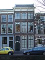 Westhaven19.jpg 972 × 1,296; 324 KB


