Category:Westerweg 11, Den Burg
Jump to navigation
Jump to search
| Object location | | View all coordinates using: OpenStreetMap |
|---|
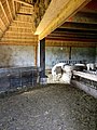
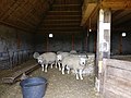
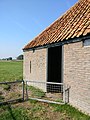
Nederlands: Boe of boet, Westerweg 11, Den Burg - anno 1850
|
This is a category about a municipal monument in Texel with number 93 |
Media in category "Westerweg 11, Den Burg"
The following 8 files are in this category, out of 8 total.
-
 Westerweg 11 - Den Burg - 1.jpg 4,102 × 3,076; 2.85 MB
-
 Westerweg 11 - Den Burg - 2.jpg 3,121 × 4,162; 2.21 MB
-
 Westerweg 11 - Den Burg - 3.jpg 4,640 × 3,480; 4.6 MB
-
 Westerweg 11 - Den Burg - 4.jpg 4,125 × 3,093; 2.54 MB
-
 Westerweg 11 - Den Burg - 5.jpg 4,640 × 3,480; 5.43 MB
-
 Westerweg 11 - Den Burg - 6.jpg 4,640 × 3,480; 5.7 MB
-
 Westerweg 11 - Den Burg - 7.jpg 3,480 × 4,640; 6.75 MB
-
 Westerweg 11 - Den Burg - 8.jpg 4,083 × 3,062; 2.37 MB


