Category:Westerstraat 9 (Winsum, Groningen)
Jump to navigation
Jump to search
| Object location | | View all coordinates using: OpenStreetMap |
|---|
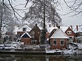
house in Winsum, Netherlands  | |||||
| Upload media | |||||
| Instance of | |||||
|---|---|---|---|---|---|
| Location | Winsum, Het Hogeland, Groningen, Netherlands | ||||
| Street address |
| ||||
| Heritage designation |
| ||||
 | |||||
Voorhuis
|
This is a category about rijksmonument number 39045
|
Achterhuis, vh. Westerstraat 13
|
This is a category about rijksmonument number 39046
|
| Address |
|
Media in category "Westerstraat 9 (Winsum, Groningen)"
The following 12 files are in this category, out of 12 total.
-
 Achterzijde - Obergum - 20170654 - RCE.jpg 1,195 × 1,200; 366 KB
-
 Achterzijde - Obergum - 20170655 - RCE.jpg 1,200 × 1,191; 415 KB
-
 Arbeiderswoningen - Winsum - 20525046 - RCE.jpg 1,200 × 900; 159 KB
-
 Arbeiderswoningen - Winsum - 20525047 - RCE.jpg 1,200 × 900; 144 KB
-
 Dakraam.JPG 3,456 × 2,592; 3.4 MB
-
 Kerstkaart 2005.JPG 2,048 × 1,536; 1.01 MB
-
 Nu B&B.JPG 3,456 × 2,592; 1.44 MB
-
 Slaap ze!.JPG 3,456 × 2,592; 2.69 MB
-
 Voorheen nr. 13.JPG 2,592 × 3,456; 4.2 MB
-
 Winsum - Westerstraat 9.jpg 4,000 × 3,000; 4.53 MB
-
 Winsumerdiep - Winsum - 20215180 - RCE.jpg 1,197 × 1,200; 445 KB
-
 Winsumerdiep - Winsum - 20215192 - RCE.jpg 1,200 × 1,200; 340 KB


