Category:Westburn, South Lanarkshire
Jump to navigation
Jump to search
suburb of Cambuslang, South Lanarkshire, Scotland, United Kingdom | |||||
| Upload media | |||||
| Instance of | |||||
|---|---|---|---|---|---|
| Location |
| ||||
 | |||||
Images of the district of Westburn in Cambuslang, South Lanarkshire, Scotland.
Media in category "Westburn, South Lanarkshire"
The following 36 files are in this category, out of 36 total.
-
 Cambuslang Golf Club - Club House - geograph.org.uk - 580753.jpg 640 × 480; 85 KB
-
 Cambuslang, Western Golf Course, Dovecot.jpg 4,950 × 3,284; 6.67 MB
-
 Cambuslang4.jpg 1,920 × 1,080; 1.21 MB
-
 Car park at Scot Kart - geograph.org.uk - 1309766.jpg 480 × 640; 62 KB
-
 Carmyle Weir - geograph.org.uk - 1359124.jpg 640 × 480; 138 KB
-
 Clyde Walkway nearing Cambuslang (geograph 1687588).jpg 640 × 480; 106 KB
-
 Cycle path, West Burn - geograph.org.uk - 1304414.jpg 640 × 359; 85 KB
-

-
 Entrance to kart racing track - geograph.org.uk - 1307231.jpg 480 × 640; 63 KB
-
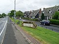
 Houses on Westburn Road, Westburn Village (geograph 6966679).jpg 800 × 526; 82 KB
-
 Indoor kart racing track - geograph.org.uk - 1307229.jpg 453 × 604; 96 KB
-

-
 Map of Glasgow and its Environs OS Map name 011-05, Ordnance Survey, 1857-1893.png 11,355 × 7,581; 20.68 MB
-
 National Cycle Route 75, Westburn - geograph.org.uk - 1229466.jpg 640 × 480; 126 KB
-
 NCR75 passing Westburn Grid substation (geograph 7228155).jpg 1,024 × 768; 225 KB
-
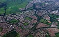 Newton and Cambuslang from the air (geograph 2988822) (cropped).jpg 615 × 384; 157 KB
-
 Newton and Cambuslang from the air (geograph 2988822).jpg 640 × 480; 190 KB
-
 Newton Court (geograph 5264163).jpg 640 × 480; 62 KB
-
 Northbank Avenue - geograph.org.uk - 1229458.jpg 640 × 480; 115 KB
-
 Playpark, Westburn Village - geograph.org.uk - 1359182.jpg 640 × 480; 104 KB
-
 Pylons and the River Clyde - geograph.org.uk - 1359160.jpg 640 × 480; 106 KB
-
 Pylons from the Clyde Walkway - geograph.org.uk - 1359094.jpg 640 × 480; 110 KB
-
 River Clyde - geograph.org.uk - 1304428.jpg 640 × 480; 99 KB
-
 River Clyde from Clyde Walkway - geograph.org.uk - 1359104.jpg 640 × 480; 175 KB
-
 Rough ground, Cambuslang - geograph.org.uk - 1304438.jpg 640 × 359; 81 KB
-
 Substation, Westburn - geograph.org.uk - 1304420.jpg 640 × 359; 96 KB
-
 Takeaway on Westburn Road (geograph 6966676).jpg 800 × 546; 70 KB
-
 The River Clyde at Carmyle (geograph 3746751).jpg 640 × 480; 98 KB
-
 Weir at Carmyle - geograph.org.uk - 939889.jpg 640 × 480; 86 KB
-
 Westburn Road (geograph 5264166).jpg 640 × 480; 66 KB
-
 Westburn Road, Cambuslang (geograph 6966672).jpg 800 × 600; 102 KB
-
 Westburn Village - geograph.org.uk - 1359171.jpg 640 × 480; 116 KB
-
 Westburn Village - geograph.org.uk - 1359175.jpg 640 × 480; 132 KB
-
 Westburn-Newton hill from east (geograph 4894701).jpg 1,024 × 768; 161 KB
-
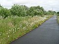 Wild flowers by the Clyde Walkway - geograph.org.uk - 1359115.jpg 640 × 480; 150 KB
-
 Wilson Waste Services - geograph.org.uk - 1304434.jpg 640 × 359; 97 KB


.jpg)


.jpg)


.jpg)
_(cropped).jpg)
.jpg)
.jpg)


.jpg)
.jpg)

.jpg)
.jpg)


.jpg)

