Category:Well, Lincolnshire
Jump to navigation
Jump to search
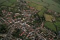
English: Well is a small estate village and civil parish in the East Lindsey district of Lincolnshire, England that is situated on the foot of the east entry to the Lincolnshire Wolds. The village is a picturesque as it provides good views of the gradually sloping hills towards the west. In the village there is a church, a telephone box, a post box and a bus shelter with an excellent callconnect bus service.
village and civil parish in Lincolnshire, UK  | |||||
| Upload media | |||||
| Instance of | |||||
|---|---|---|---|---|---|
| Location | East Lindsey, Lincolnshire, East Midlands, England | ||||
| Population |
| ||||
 | |||||
Subcategories
This category has the following 2 subcategories, out of 2 total.
S
W
- Well Vale Hall, Lincolnshire (11 F)
Media in category "Well, Lincolnshire"
The following 74 files are in this category, out of 74 total.
-

-
-
 Alford centre, aerial 2017 (1) - geograph.org.uk - 5361484.jpg 640 × 427; 88 KB
-
 Alford centre, aerial 2017 (2) - geograph.org.uk - 5361500.jpg 1,024 × 683; 173 KB
-
 Alford Crematorium - geograph.org.uk - 3098506.jpg 2,256 × 1,504; 1.52 MB
-
 Alford to Farlesthorpe, aerial 2014 - geograph.org.uk - 3800650.jpg 640 × 394; 56 KB
-
 Arable fields being sprayed near Well - geograph.org.uk - 2391435.jpg 3,296 × 2,472; 1.96 MB
-
 Arable fields near Well Grange - geograph.org.uk - 2393976.jpg 3,296 × 2,472; 1.97 MB
-
 Bridleway past Low Wood - geograph.org.uk - 3862462.jpg 640 × 427; 70 KB
-
 Bridleway to Well - geograph.org.uk - 231882.jpg 640 × 480; 97 KB
-
 Chalk pit, Well Vale, aerial so14 - geograph.org.uk - 3891964.jpg 1,024 × 683; 174 KB
-
 Chalk pit, Well Vale, aerial so14 - geograph.org.uk - 3891966.jpg 640 × 427; 64 KB
-
 Cross roads at Miles Cross - geograph.org.uk - 3005552.jpg 640 × 521; 61 KB
-
 Crossing Cottage Well - geograph.org.uk - 2394047.jpg 3,296 × 2,472; 1.97 MB
-
 Crossing Keeper's cottage - geograph.org.uk - 3595352.jpg 640 × 427; 80 KB
-
 Crossing Keeper's cottage, detail - geograph.org.uk - 3595362.jpg 640 × 427; 68 KB
-
 Crossing Keeper's cottage, detail - geograph.org.uk - 3595373.jpg 640 × 427; 65 KB
-

-
 Entrance to Wellbeck Grainstore - geograph.org.uk - 3862434.jpg 640 × 427; 42 KB
-
 Estate cottages in Well - geograph.org.uk - 3595326.jpg 640 × 427; 61 KB
-

-
 Former GNR railway line - geograph.org.uk - 2054342.jpg 640 × 426; 171 KB
-
 Front view of St. Margaret's Church - geograph.org.uk - 3861769.jpg 1,024 × 683; 161 KB
-

-
 House at the eastern end of Well Grange's drive - geograph.org.uk - 3861734.jpg 1,024 × 683; 233 KB
-
 Junction of roads in Well - geograph.org.uk - 6074927.jpg 4,000 × 3,000; 3.49 MB
-
 Junction of Well High Lane and Miles Cross Lane (A1104) - geograph.org.uk - 3098516.jpg 2,256 × 1,504; 2.13 MB
-

-
 Lane facing east north east from below Well Beck bridleway. - geograph.org.uk - 2391451.jpg 3,296 × 2,472; 1.94 MB
-
 Long gone lines - geograph.org.uk - 2054325.jpg 640 × 426; 117 KB
-
 Looking across A1104 into Well High Lane - geograph.org.uk - 3862515.jpg 1,024 × 683; 148 KB
-

-
 Mawthorpe Gauging Station - geograph.org.uk - 3862445.jpg 640 × 427; 91 KB
-
 Mawthorpe Hill Road (B1196) - geograph.org.uk - 3436894.jpg 2,256 × 1,504; 1.85 MB
-

-
 National speed limit applies on leaving Well - geograph.org.uk - 6074244.jpg 4,000 × 3,000; 3.57 MB
-
 Road into Rigsby - geograph.org.uk - 3862634.jpg 640 × 427; 50 KB
-
 Road to Well via Sleights Holt - geograph.org.uk - 3861736.jpg 640 × 427; 61 KB
-
 St Margaret's Church, Well - geograph.org.uk - 6368684.jpg 1,360 × 2,048; 728 KB
-

-
 St. Margaret's churchyard, Well - geograph.org.uk - 3861777.jpg 1,024 × 683; 282 KB
-

-
 The bridleway to Mawthorpe from Well - geograph.org.uk - 3595347.jpg 640 × 427; 69 KB
-
 The former Great Northern Railway line - geograph.org.uk - 2394040.jpg 3,296 × 2,472; 2.05 MB
-
 Track from Claxby Grange - geograph.org.uk - 1938811.jpg 640 × 480; 73 KB
-
 Track into Forest Wood - geograph.org.uk - 3434025.jpg 2,256 × 1,504; 3.13 MB
-
 Track into Forest Wood from Badger Hill - geograph.org.uk - 3861782.jpg 640 × 427; 113 KB
-
 Track towards Low Wood - geograph.org.uk - 3552565.jpg 2,256 × 1,504; 2.38 MB
-
 Track with Blossoms - geograph.org.uk - 3436880.jpg 1,504 × 2,256; 3.1 MB
-

-
 Unnamed lane towards Sleights Holt - geograph.org.uk - 3537780.jpg 2,256 × 1,504; 1.75 MB
-
 Well and Well Vale, 2014 aerial-geograph-3800947.jpg 640 × 427; 55 KB
-
 Well Beck bridleway - geograph.org.uk - 2054283.jpg 640 × 426; 84 KB
-
 Well Beck bridleway - geograph.org.uk - 2054421.jpg 640 × 426; 99 KB
-
 Well Beck Wath - geograph.org.uk - 2054292.jpg 640 × 426; 80 KB
-
 Well communications hub - geograph.org.uk - 2054718.jpg 640 × 426; 174 KB
-
 Well High Lane near to the entrance to Well Grange - geograph.org.uk - 6074238.jpg 4,000 × 3,000; 4.67 MB
-
 Well lane - Well - geograph.org.uk - 2393987.jpg 3,296 × 2,472; 1.94 MB
-
 Well Lane bridleway - geograph.org.uk - 2393979.jpg 3,296 × 2,472; 1.92 MB
-
 Well Lane Trees - geograph.org.uk - 232407.jpg 640 × 480; 142 KB
-
 Well Turn - geograph.org.uk - 231885.jpg 640 × 480; 91 KB
-
 Well Turn aka turn-off to Well - geograph.org.uk - 3867024.jpg 640 × 427; 55 KB
-

-

-
 Well Vale Hall, aerial 2016 - geograph.org.uk - 4959129.jpg 427 × 640; 50 KB
-
 Well Vale parkland - geograph.org.uk - 2054683.jpg 640 × 426; 101 KB
-
 Well Vale, Park - geograph.org.uk - 3595294.jpg 640 × 427; 79 KB
-
 Wellvale House (Well Vale Hall), Well, Alford - geograph.org.uk - 6368726.jpg 2,048 × 1,360; 830 KB
-

-
 Woodland near Well - geograph.org.uk - 595797.jpg 640 × 480; 130 KB
-
 Woodland near Well - geograph.org.uk - 595804.jpg 640 × 480; 114 KB
-
 Woodland near Well - geograph.org.uk - 595810.jpg 640 × 480; 145 KB
-
 Woodland near Well - geograph.org.uk - 595818.jpg 640 × 480; 132 KB
-
 Woodland near Well - geograph.org.uk - 595821.jpg 640 × 480; 121 KB
_-_geograph.org.uk_-_5301971.jpg)

_-_geograph.org.uk_-_5361484.jpg)
_-_geograph.org.uk_-_5361500.jpg)


_-_geograph.org.uk_-_3098516.jpg)


_-_geograph.org.uk_-_3436894.jpg)


,_Well,_Alford_-_geograph.org.uk_-_6368726.jpg)


