Category:Weinstraße 81 (Forst an der Weinstraße)
Jump to navigation
Jump to search
| Object location | | View all coordinates using: OpenStreetMap |
|---|

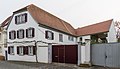
Weinstraße 81 house
- Late baroque half hipped roof building, second half of the 18th century.
Media in category "Weinstraße 81 (Forst an der Weinstraße)"
The following 2 files are in this category, out of 2 total.
-
 089 2015 03 25 Kulturdenkmaeler Forst.jpg 2,939 × 1,701; 3.37 MB
-
 090 2015 03 25 Kulturdenkmaeler Forst.jpg 1,894 × 2,639; 2.98 MB

