Category:Weinstraße 50 (Forst an der Weinstraße)
Jump to navigation
Jump to search
| Object location | | View all coordinates using: OpenStreetMap |
|---|

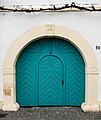
Weinstraße 50 Small winery
- Early 19th century.
- Post-baroque house with half hipped roof, gateway designated 1801, farm building with older remains, former stable designated 1725.
Media in category "Weinstraße 50 (Forst an der Weinstraße)"
The following 4 files are in this category, out of 4 total.
-
 040 2015 03 25 Kulturdenkmaeler Forst.jpg 2,665 × 1,876; 3.36 MB
-
 041 01 2021 12 06 Kulturdenkmaeler Forst.jpg 2,932 × 2,967; 2.11 MB
-
 041 2015 03 13 Kulturdenkmaeler Forst.jpg 2,050 × 2,437; 3.71 MB
-
 042 2015 03 25 Kulturdenkmaeler Forst.jpg 2,430 × 2,056; 3.13 MB


