Category:Weißkeißel, Feierhalle des Friedhofs
Jump to navigation
Jump to search
| Object location | | View all coordinates using: OpenStreetMap |
|---|
.jpg) | |||||
| Upload media | |||||
| Instance of | |||||
|---|---|---|---|---|---|
| Location | Weißkeißel, Görlitz, Saxony, Germany | ||||
| Street address |
| ||||
| Heritage designation | |||||
 | |||||
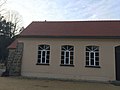
Deutsch: Feierhalle des Friedhofs in Weißkeißel, errichtet in den 1950er Jahren; baugeschichtliches Zeugnis der Nachkriegszeit; Kulturdenkmal
English: Celebration hall of the cemetery in Weißkeißel, built in the 1950s; architectural testimony of the postwar period; cultural heritage monument
| (Wikidata) |
Media in category "Weißkeißel, Feierhalle des Friedhofs"
The following 9 files are in this category, out of 9 total.
-
 Weißkeißel, Feierhalle des Friedhofs (1).jpg 4,032 × 3,024; 3.01 MB
-
 Weißkeißel, Feierhalle des Friedhofs (2).jpg 4,032 × 3,024; 2.52 MB
-
 Weißkeißel, Feierhalle des Friedhofs (3).jpg 6,738 × 3,840; 5.19 MB
-
 Weißkeißel, Feierhalle des Friedhofs (3a).jpg 4,032 × 3,024; 2.27 MB
-
 Weißkeißel, Feierhalle des Friedhofs (3b).jpg 4,032 × 3,024; 2.4 MB
-
 Weißkeißel, Feierhalle des Friedhofs (3c).jpg 7,837 × 4,124; 14.54 MB
-
 Weißkeißel, Feierhalle des Friedhofs (4).jpg 4,032 × 3,024; 2.36 MB
-
 Weißkeißel, Feierhalle des Friedhofs (5).jpg 4,032 × 3,024; 2.29 MB
-
 Weißkeißel, Feierhalle des Friedhofs (6).jpg 4,032 × 3,024; 2.3 MB
.jpg)
.jpg)
.jpg)
.jpg)
.jpg)
.jpg)
.jpg)
.jpg)