Category:Wealden hall houses
Jump to navigation
Jump to search
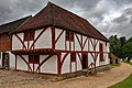
The Wealden hall house is a type of vernacular medieval timber-framed hall house traditional in the south east of England. It is most common in Kent (hence "Wealden" for the once densely forested Weald) and the east of Sussex but has also been built elsewhere. A 'hall house' is a one storey and one room building originally serving all aspects of accommodation; later often partitioned into separate rooms and/or separate floors.
mediaeval house design  | |||||
| Upload media | |||||
| Subclass of | |||||
|---|---|---|---|---|---|
| |||||
Subcategories
This category has the following 24 subcategories, out of 24 total.
1
- 131 High Street, Stevenage (2 F)
2
- 25 The Street, Newnham (2 F)
- 29-33 High Street, Tenterden (7 F)
A
- Anne of Cleves House (27 F)
C
- Chapter Farmhouse (5 F)
- Claxfield Farm (2 F)
F
- Farm Cottages, Maidstone (2 F)
H
- Hendon Place, Kent (3 F)
L
- Wealden Hall, Larkfield (2 F)
- Link House, Ashford (1 F)
M
- Monk's Barn, Essex (8 F)
- Mulberry Cottage, Snodland (4 F)
O
- The Old House, Wissenden (2 F)
- Old Punch Bowl, Crawley (14 F)
- Oxenbridge Farm (3 F)
P
- Pattyndenne Manor (2 F)
- The Pilgrims Rest Restaurant (14 F)
- Priest House, West Hoathly (21 F)
R
- Rosebank, Robertsbridge (2 F)
V
- Valewood Farm (9 F)
- Vineys Cottages, Leeds (3 F)
Y
- The Yeoman's House, Bignor (9 F)
Media in category "Wealden hall houses"
The following 96 files are in this category, out of 96 total.
-
 1 and 2 Bakers Cross, Cranbrook - geograph.org.uk - 1309370.jpg 640 × 480; 109 KB
-
 11, 13 and 15 Museum Street, Saffron Walden, October 2023.jpg 4,032 × 3,024; 3.93 MB
-
 123 and 125 Bridge Street, Wye, Kent - geograph.org.uk - 1393600.jpg 640 × 427; 81 KB
-
 24 High Street, Wingham, Kent - geograph.org.uk - 1385684.jpg 640 × 427; 79 KB
-
 40 High Street, Wingham, Kent - geograph.org.uk - 1385681.jpg 640 × 480; 75 KB
-
 41, 43 and 45 Castle Street, Saffron Walden, October 2023.jpg 4,032 × 3,024; 3.86 MB
-
 47 and 49 Castle Street, Saffron Walden, October 2023.jpg 4,032 × 3,024; 3.81 MB
-

-
 51 Castle Street, Saffron Walden, October 2023.jpg 3,024 × 4,032; 3.2 MB
-
 Altstadt Wiehl.JPG 4,272 × 2,848; 7.57 MB
-
-

-
 ChathamCapstone3937.JPG 2,016 × 1,512; 685 KB
-

-

-
 Coggers - geograph.org.uk - 1709598.jpg 2,580 × 1,932; 1.55 MB
-
 Coggers Cottage - geograph.org.uk - 1709608.jpg 2,580 × 1,932; 1.35 MB
-
-

-
 Cranbrook, Kent.jpg 1,600 × 1,200; 238 KB
-

-
 Flushing - Kiln Quay House.jpg 3,024 × 4,032; 3.27 MB
-

-
-

-

-

-

-

-

-
 Kemp's, Potter's Lane, Hawkhurst, Kent - geograph.org.uk - 1309675.jpg 640 × 427; 112 KB
-
 Kingpost Rolvenden Geograph-3649483-by-David-Kemp.jpg 640 × 427; 97 KB
-
-

-
 Little Tilden, Ulcombe Road, Headcorn - geograph.org.uk - 1310820.jpg 640 × 427; 103 KB
-

-
 Mansion Farmhouse, Liverton Street, Kent - geograph.org.uk - 1051576.jpg 640 × 480; 113 KB
-
 Margavon Cottage, Charcott, Kent - geograph.org.uk - 1382090.jpg 640 × 427; 129 KB
-

-
 North Cray medieval house.jpg 850 × 567; 568 KB
-

-
 Old Punch Bowl.JPG 1,920 × 2,560; 1,009 KB
-
 "Tullys" in The Spain. - geograph.org.uk - 17471.jpg 640 × 426; 56 KB
-
 Pond near Hatchetts - geograph.org.uk - 1751607.jpg 2,560 × 1,920; 1.8 MB
-
 Prings, Pilgrim's Way, Halling, Kent - geograph.org.uk - 1314866.jpg 640 × 427; 118 KB
-

-
 Roses farmhouse monochrome.jpg 2,448 × 3,264; 1.71 MB
-
 Roses farmhouse.jpg 1,713 × 1,942; 928 KB
-
 Rural Redevelopment - geograph.org.uk - 1363896.jpg 640 × 480; 98 KB
-

-
-

-
 Sole St medieval house.jpg 850 × 567; 823 KB
-

-

-

-

-
 The Clergy House, Alfriston - geograph.org.uk - 1260729.jpg 640 × 427; 76 KB
-
 The Clergy House, Alfriston. - geograph.org.uk - 175351.jpg 640 × 437; 153 KB
-
 The Griffin's Head, Chillenden - geograph.org.uk - 1500356.jpg 640 × 454; 90 KB
-
 The Griffin's Head, Chillenden, Kent - geograph.org.uk - 1385621.jpg 640 × 427; 82 KB
-
 The Moat, Cranbrook Road, Benenden, Kent - geograph.org.uk - 1298491.jpg 640 × 458; 103 KB
-

-

-

-
 Tilmenden, Stone Cum Ebony, Kent - geograph.org.uk - 1756276.jpg 640 × 480; 88 KB
-
 Tilmenden, Stone Cum Ebony, Kent - geograph.org.uk - 1756286.jpg 640 × 427; 95 KB
-

-
-

-
 Waltham St Lawrence - geograph.org.uk - 16636.jpg 640 × 431; 101 KB
-
 Waltham St Lawrence - geograph.org.uk - 524865.jpg 640 × 480; 139 KB
-
 Wanden Farmhouse, Wanden Road, Egerton - geograph.org.uk - 1614318.jpg 640 × 427; 107 KB
-

-

-
-

-

-

-
-

-

-

-

-

-

-

-

-

-

-

-

-
 Yew Tree House - geograph.org.uk - 1281978.jpg 480 × 640; 105 KB
-

-
 Half timbered house, Brewer St - geograph.org.uk - 1705051.jpg 640 × 427; 57 KB
-
 Oldbury Hall, Oldbury Lane, Ightham - geograph.org.uk - 608087.jpg 631 × 421; 103 KB


