Category:Weald, Kent
Jump to navigation
Jump to search
Subcategories
This category has the following 2 subcategories, out of 2 total.
O
W
- Weald War Memorial, Kent (1 F)
Media in category "Weald, Kent"
The following 89 files are in this category, out of 89 total.
-
-
 Anchor Cottage, Hubbard's Hill - geograph.org.uk - 1382087.jpg 640 × 384; 80 KB
-
 Barn, Bowzell Rd - geograph.org.uk - 1380189.jpg 640 × 430; 158 KB
-
 Barn, Colehurst Farm - geograph.org.uk - 1381949.jpg 640 × 430; 131 KB
-
 Barn, Colehurst Farm - geograph.org.uk - 1381969.jpg 640 × 430; 150 KB
-
 Bend in Long Barn Rd near Weald - geograph.org.uk - 1380203.jpg 640 × 430; 176 KB
-
 Brook Cottage, Church Rd, Weald - geograph.org.uk - 1382181.jpg 640 × 430; 131 KB
-
 Byway south of Weald (2) - geograph.org.uk - 1378184.jpg 640 × 430; 174 KB
-
 Byway south of Weald (3) - geograph.org.uk - 1378187.jpg 640 × 430; 184 KB
-
 Byway south of Weald (4) - geograph.org.uk - 1378188.jpg 640 × 430; 187 KB
-
 Byway south of Weald - geograph.org.uk - 1378182.jpg 640 × 430; 194 KB
-
 Byway to Weald, Hale Oak Rd - geograph.org.uk - 1378202.jpg 640 × 430; 184 KB
-
 Cattle by Hubbard's Hill - geograph.org.uk - 1382081.jpg 640 × 430; 131 KB
-
 Cattle grazing, Colehurst Farm - geograph.org.uk - 1381987.jpg 640 × 430; 147 KB
-
 Chicken Shed, Colehurst Farm - geograph.org.uk - 1381960.jpg 640 × 430; 134 KB
-
 Colehurst Farm - geograph.org.uk - 1381996.jpg 640 × 430; 101 KB
-

-
 Cottage, Hale Oak Rd - geograph.org.uk - 1380178.jpg 640 × 430; 175 KB
-
 Cottage, Wickhurst Rd - geograph.org.uk - 1381885.jpg 640 × 430; 84 KB
-
 Cottages facing the village green, Weald - geograph.org.uk - 1378171.jpg 640 × 430; 127 KB
-
 Cows grazing near Weald - geograph.org.uk - 1378179.jpg 640 × 430; 152 KB
-
 Dale Farm (2) - geograph.org.uk - 1382006.jpg 640 × 200; 55 KB
-
 Dale Farm - geograph.org.uk - 1381999.jpg 640 × 430; 103 KB
-
 Demolished Cottage on Wickhurst Road - geograph.org.uk - 1542938.jpg 640 × 427; 101 KB
-

-

-
 Elmfield Close, Weald - geograph.org.uk - 1380232.jpg 640 × 430; 124 KB
-
 Everest Farm, Church Rd, Weald - geograph.org.uk - 1382166.jpg 640 × 430; 146 KB
-
 Farmhouse, Dale Farm - geograph.org.uk - 1382018.jpg 640 × 430; 168 KB
-
 Farmyard, Colehurst Farm - geograph.org.uk - 1381913.jpg 640 × 430; 95 KB
-
 Fields north of Wickhurst Rd, Weald - geograph.org.uk - 1381851.jpg 640 × 430; 160 KB
-
 Footbridge on the byway south of Weald - geograph.org.uk - 1378193.jpg 640 × 430; 192 KB
-
 Footpath off Hale Oak Rd - geograph.org.uk - 1380172.jpg 640 × 430; 203 KB
-
 Footpath off Hubbard's Hill - geograph.org.uk - 1382129.jpg 640 × 430; 190 KB
-
 Footpath off Long Barn Rd, Weald - geograph.org.uk - 1380209.jpg 640 × 430; 167 KB
-
 Footpath off Wickhurst Rd - geograph.org.uk - 1381875.jpg 640 × 411; 125 KB
-
 Footpath over a stile, Hale Oak Rd - geograph.org.uk - 1378197.jpg 640 × 430; 134 KB
-
 Footpath towards the centre of Weald - geograph.org.uk - 1378178.jpg 640 × 430; 174 KB
-

-
 Greensand Way off Hubbard's Hill - geograph.org.uk - 1382069.jpg 640 × 430; 171 KB
-
 Hale Oak Rd - geograph.org.uk - 1378200.jpg 640 × 430; 159 KB
-
 Hale Oak Rd, north (2) - geograph.org.uk - 1380188.jpg 640 × 430; 146 KB
-
 Hale Oak Rd, north - geograph.org.uk - 1380185.jpg 640 × 430; 176 KB
-
 Hubbard's Hill Bridge - geograph.org.uk - 1382092.jpg 640 × 430; 143 KB
-
 Hubbard's Hill north of Weald - geograph.org.uk - 1382076.jpg 640 × 430; 169 KB
-
 Hurst Farm House, Church Rd, Weald - geograph.org.uk - 1382171.jpg 640 × 417; 88 KB
-
 Long Barn Rd, Weald - geograph.org.uk - 1380216.jpg 640 × 430; 139 KB
-

-

-
 Millennium plaque - geograph.org.uk - 1049740.jpg 640 × 479; 158 KB
-
 Millfield, Wickhurst Rd, Weald - geograph.org.uk - 1381860.jpg 640 × 430; 161 KB
-
 Mount Pleasant Rd, Weald - geograph.org.uk - 1380241.jpg 640 × 430; 135 KB
-
 New footpath around Weald Place - geograph.org.uk - 1533408.jpg 640 × 427; 135 KB
-
 New Footpath Map around Weald Place - geograph.org.uk - 1533418.jpg 427 × 640; 47 KB
-
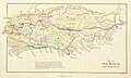
 Ordnance Survey One-Inch Sheet 126 Weald of Kent, Published 1927.jpg 11,876 × 8,922; 10.88 MB
-

-
 Prospect terrace, Long Barn Rd, Weald - geograph.org.uk - 1380218.jpg 640 × 430; 141 KB
-

-
 Sheep and Barn, Colehurst Farm - geograph.org.uk - 1381980.jpg 640 × 360; 74 KB
-
 Sheep grazing, Colehurst Farm - geograph.org.uk - 1381940.jpg 640 × 430; 165 KB
-
 Sheep grazing, Wickhurst Rd (2) - geograph.org.uk - 1381895.jpg 640 × 430; 144 KB
-
 Sheep grazing, Wickhurst Rd - geograph.org.uk - 1381891.jpg 640 × 430; 161 KB
-
 Sheep, Wickhurst Rd - geograph.org.uk - 1381956.jpg 640 × 430; 155 KB
-
-
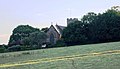
 St George's Church, Weald - geograph.org.uk - 1382139.jpg 640 × 430; 85 KB
-

-
 The Millennium Plaque, The Green, Weald - geograph.org.uk - 1378169.jpg 640 × 430; 156 KB
-
 The New Cottage, Long Barn Rd, Weald - geograph.org.uk - 1380212.jpg 640 × 430; 178 KB
-
 The Old Bakery, Weald. - geograph.org.uk - 1380226.jpg 640 × 435; 90 KB
-
 The Old School House, Glebe Rd - geograph.org.uk - 1382146.jpg 640 × 430; 134 KB
-
 Three trees north of the Greensand Way - geograph.org.uk - 1382035.jpg 640 × 430; 143 KB
-
 Track to Colous Shaw, Wickhurst Rd - geograph.org.uk - 1381880.jpg 640 × 430; 196 KB
-

-
 Track to Roughets, Wickhurst Rd - geograph.org.uk - 1381901.jpg 640 × 430; 181 KB
-

-
 View south from Hubbards Hill - geograph.org.uk - 1382047.jpg 640 × 430; 112 KB
-
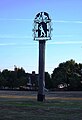 Village Sign, village green, Weald - geograph.org.uk - 1381889.jpg 437 × 640; 76 KB
-
 Watersmeet, Wickhurst Rd - geograph.org.uk - 1381870.jpg 640 × 430; 176 KB
-

-
 Weald Community Primary School, Weald - geograph.org.uk - 1380228.jpg 640 × 430; 127 KB
-
 Weald Garage, Windmill Rd, Weald - geograph.org.uk - 1380236.jpg 640 × 430; 132 KB
-
 Weald Methodist church, Weald - geograph.org.uk - 1380222.jpg 640 × 430; 149 KB
-
 Weald Recreation Ground, Weald - geograph.org.uk - 1381841.jpg 640 × 430; 102 KB
-
 Weald village green - geograph.org.uk - 1049732.jpg 640 × 476; 100 KB
-
 WealdfromDowns.JPG 640 × 480; 29 KB
-

-
 Wickhurst Rd, Weald (2) - geograph.org.uk - 1381845.jpg 640 × 430; 175 KB
-
 Wickhurst Rd, Weald - geograph.org.uk - 1381839.jpg 640 × 468; 111 KB
-
 Wickhurst Rd, Weald - geograph.org.uk - 1381918.jpg 640 × 430; 180 KB
%27_(11072630923).jpg)


_-_geograph.org.uk_-_1378184.jpg)
_-_geograph.org.uk_-_1378187.jpg)
_-_geograph.org.uk_-_1378188.jpg)


_-_geograph.org.uk_-_1380188.jpg)


_-_geograph.org.uk_-_1378196.jpg)


_-_geograph.org.uk_-_1380219.jpg)


_-_geograph.org.uk_-_1381895.jpg)


_-_geograph.org.uk_-_1380229.jpg)


_-_geograph.org.uk_-_1381845.jpg)


_-_geograph.org.uk_-_1382006.jpg)