Category:Waychinicup River
Jump to navigation
Jump to search
river in Western Australia, Australia  | |||||
| Upload media | |||||
| Instance of | |||||
|---|---|---|---|---|---|
| Location | Western Australia, AUS | ||||
| Length |
| ||||
| Mouth of the watercourse | |||||
 | |||||
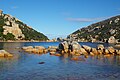
English: The Waychinicup River is located in the Great Southern region of Western Australia. The headwaters of the river are located near the town of Manypeaks along the South Coast Highway, with an elevation of approximately above sea level and flows in a generally southerly direction through the Mount Manypeaks Range then through the Waychinicup National Park until it discharges into the Southern Ocean. (→Waychinicup River)
Français : Le Waychinicup ou Waychinicup River est un fleuve côtier situé dans la région du Great Southern en Australie-Occidentale. (→Waychinicup River)
Media in category "Waychinicup River"
This category contains only the following file.
-
 Waychinicup1.jpg 3,008 × 2,000; 3.09 MB